 |
| The Route of the Lewis and Clark Expedition |
The Columbia River
The Columbia River has shaped the history of the Pacific
Northwest for thousands of years. Ancient peoples, explorers ands settlers moving
west, and atomic history, the Columbia River has seen it all. In this post, we will focus on Lewis and
Clark and their Corps of Discovery who wintered at the mouth of the Columbia in
1805-1806. Future blogs will cover Fort Vancouver National Historic Site, the
Bonneville Dam, and the Hanford Manhattan Project National Historical Park.
 |
| The Columbia RIver where Celilo Falls used to be (Photo by Hunner |
The Columbia is the longest river in the Pacific Northwest,
originating in Canada and flowing 1,243 miles (2,000 kilometers) to the Pacific
Ocean. Long before Europeans arrived, people had canoed it, fished it, lived
it. The Columbia broadly sweeps through canyons and gorges, its pounding waters
gushing over waterfalls, and its salmon provides sustenance and spirit to the
native peoples along its banks, all this attest to its greatness.
Soon after humans migrated across the Bering Strait around
15,000 years ago, people started living along the Columbia River. Archeologists
have found human remains that date back to 11,000 years ago, and in 1996, two
college students discovered the skeleton of a 9,000 year old man on the banks
of the Columbia River near Kennewick, Washington. This set off a bitter fight
between scientists (who wanted to study the skeleton) and tribal members (who
wanted the remains respectfully reburied). Legal maneuvers delayed the reburial
of the Kennewick Man (aka The Ancient One) and allowed scientists to examine
the bones in 2005. In 2015, scientists in Denmark determined through DNA
testing that the Kennewick Man was indeed related to the tribes in the area, in
particular to the Confederated Tribes of the Colville Reservation—the only group
that allowed the collection of their DNA. His remains are still stored at the
Burke Museum at the University of Washington while the legal battles continue.
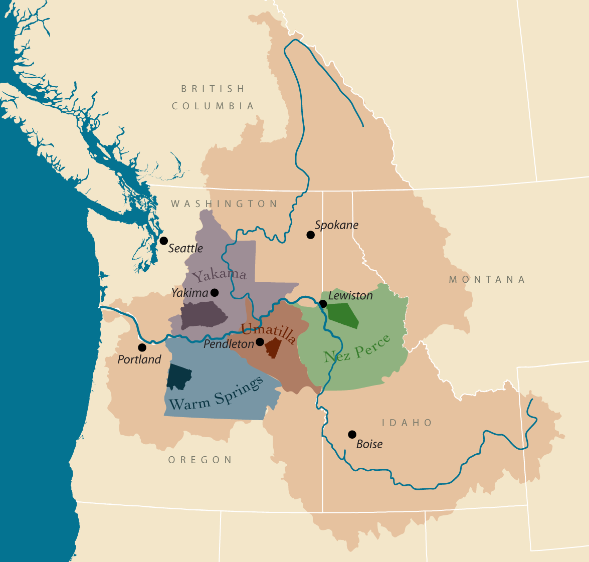 |
| Map of Native American Tribes along the Columbia (http://www.critfc.org/member_tribes_overview) |
The Native Americans along the Columbia River speak either
the Sahaptian and Chinookan languages and include the Nez Perce, the Umatilla,
the Warm Springs, the Colville, and the Yakama. The Columbia River Intertribal
Fish Commission stresses the importance of the river: “The people of these
tribes share a common understanding that their very existence depends on the
respectful enjoyment of the Columbia River Basin’s vast land and water
resources. They believe their very souls and spirits were and are inextricably
tied to the natural world and all its inhabitants. Among those inhabitants,
none are more important than the millions of salmon that bring sustenance and
prosperity to the region’s rivers and streams.”
The river brings salmon, and salmon brings life. These tribes have
fished the Columbia for thousands of years and even today, continue to spear
and net salmon on its banks. In fact, they eat ten times the average amount per
person of salmon as the rest of the country.
For centuries past, the falls at the Dalles on the Columbia
served as a Native American central meeting place for fishing, trading, and
ceremonial renewal. Especially in the seasons when salmon ran up the river, native
peoples gathered and brought goods from their regions to trade. As seen
elsewhere with pre-contact Native Americans, a vibrant and sophisticated
culture existed that had vastly different world views than those of the
approaching Europeans.
Enter the Europeans
Europeans entered by ship in the late 18th century. Then
after the turn of the 19th century, the Corps of Discovery led by
William Clark and Meriwether Lewis paddled down the Columbia and fulfilled
their mission from President Thomas Jefferson—an exploration of the newly
purchased Louisiana Territory.
 |
| President Thomas Jefferson |
Thomas Jefferson was fascinated with the western part of the
continent and even considered sending a secret mission into what was then
foreign territory in the late 18th century. When Napoleon, strapped
for cash from his wars in Europe offered the Louisiana Territory to the U.S.
for $11,000,000, Jefferson jumped at the opportunity. After the purchase in
July 1803, he ordered and actively helped organize an expedition. With
interest, the final price was $23,000,000, still a bargain for over 800,000
square miles.
The Lewis and Clark Expedition
The Corps of Discovery had multiple goals—map the vast
landscape, search for a northwest passage, ally the indigenous peoples to the
United States and away from France and Britain, and document the flora and
fauna of these lands for possible commercial use. Jefferson’s sent this charge
to Lewis on July 4, 1803: "The object of your mission is to explore the
Missouri river, & such principal stream of it, as, by its course and
communication with the waters of the Pacific ocean, whether the Columbia, Oregon,
Colorado or any other river may offer the most direct & practicable water
communication across this continent for the purposes of commerce."
 |
| Lewis and Clark (From exhibit at the Lewis and Clark Interpretive Center, Cape Disappointment State Park) |
Most of the thirty-three members of the Corps of Discovery
were an elite group of the U.S. Army. The leaders, William Clark and Meriwether
Lewis, had already served the country well. Both had fought in the Revolutionary
War, and Lewis was Jefferson’s personal secretary. Lewis and Clark chose the men
carefully for their many skills, and picked only one out of every 100
applicants. As a costumed interpreter at Fort Clatsop, Tom Wilson, told the
Wilson Elementary School from Corvallis on the day I visited: “They were like
the Navy Seals.” Clark also brought a slave, York, the first African American
that Native Americans along the way had seen. The Corps would need their many
skills and then some luck to fulfill their mission and safely return.
The Corps spent the winter of 1803-04 at Fort DuBois near
the confluence of the Missouri and Mississippi Rivers. They set off on May 14,
1804. They went up the Missouri in a small fleet of boats, which they rowed, poled,
and pulled against the current. When the wind blew the right direction, they
sailed. After five months and 1,600 miles of tedious travel, they wintered near
the Mandan Indian villages where the temperature at times fell to 70 degrees
below zero Fahrenheit. While at Fort Mandan, they hired Toussaint Charbonneau,
a French-Canadian trader, as an interpreter. His young Shoshone wife, Sacagawea
(who had been kidnapped five years earlier), and their infant son, Jean
Baptiste, accompanied them. The Corps was now complete and ready for the
treacherous journey ahead.
 |
| Sacagawea and Jean Baptiste(Photo by Hunner at Fort Clatsop NHP) |
Having engaged and traded with the Mandan and other Plains
tribes throughout the winter, the Corps left their fort in April 1805. They
went up the Missouri River and its upper branches, struggling against the
current into unchartered landscapes. Up the Rockies with all of their supplies
and gear proved daunting and then, a miracle happened. Sacagawea ran into her
family, who had given her up for lost. The Shoshone provided much needed food,
horses, and a guide to send them over the Bitterroot Mountains.
Fort Clatsop
Near the mouth of the Columbia, after paddling down 600 miles
of the Clearwater, Snake, and Columbia River, Clark wrote in his journal: “Ocian
in view. O! the joy!” Despite the euphoria of reaching their destination, the
Corps huddled for six days at a cove of jagged rocks and steep cliffs in a
raging storm. Rain pummeled them, whose Army issued clothes were rotting away
from use and all the water. The surf crashed over their camp. Clark named the
spot “that dismal little nitch.”
Visiting Clatsop Indians told Lewis and Clark that
better camping and hunting lay to the south, so the Captains held council. In
the film at Fort Clatsop, this council brought democracy to the Northwest as
they voted on what to do, York included. Interpreter Tom has a different take.
Lewis and Clark did consult with their men, but then the Captains decided,
military style. They moved the camp across the mouth of the mighty Columbia to
where the Clatsop people said elk existed. For starving men, food ruled. Over the
winter, the Corps shot 144 elk.
The Corps lived in six small rooms at the fort —a room each for
the three squads, one for their sergeants, one for Lewis and Clark, one for the
Charbonneau family, and one for the kitchen and mess hall where York probably
slept.
 |
| The reconstruted Fort Clatsop (Photo bt Hunner) |
The Corps built Fort Clatsop in time for Christmas. Despite
the joy of reaching the Pacific, the rotten meat and nakedness from worn out
clothes set the tone. Over the four months that the Corps lived in the fort,
they hunted, laid up food for the return journey (including a salt works which boiled
seawater at a site fifteen miles to the south), and wrote in their journals. The
total words in the Journals of Lewis and Clark are more than those in the Bible,
and Clark’s maps were off by only forty miles over the four thousand that they
covered. The Corps left the fort on
March 23, 1806 for the return to St. Louis.
 |
| Interpreter Tom Wilson talking to students at the fort (Photo by Hunner) |
Tom Wilson serves Fort Clatsop in a vital role. When I first
saw him, he had engaged students from the Wilson Elementary School with the
history of Lewis and Clark. Tom was engaging, knowledgeable, and passionate
about this history. His gift in relating the people and events of over 200
years ago to twelve and thirteen year olds came from his years teaching in the
local middle school. He now spends a lot of time debunking myths: “We often
write history the way we want it to be, not the way it was.” For example, during
the trip west, the Corps at times struggled with hunger and knowing where to
go. Native peoples often provided aid. Tom held his fingers close together and said
that for a brief period of time, Jefferson envisioned the United States “co-habiting
and trading with Native Americans.”
The Corps of Discovery’s epic journey continues to capture
the imagination. Their drive to get to the Pacific and back, to establish
diplomatic relations with the tribes they encountered, and to document all they
saw opened up the west for the United
States, but also changed forever the traditional ways of life for the Native
Americans.
Fort Clatsop National Memorial was authorized in 1958 and the some sites at the mouth of the Columbian River as consolidated into a National Historical Park in 2004. The Lewis and Clark National
Historic Trail was established in 1978. The replica of Fort Clatsop was built
in 1955, destroyed by fire in October 2005, and rebuilt.
Thanks to Douglas and his insights as we visited these sites at the
mouth of the mighty Columbia River.
 |
| Me pointing out the mispellings in Clark's Journal entry (Photo by Douglas Hoffman) |