Translate

Thursday, December 6, 2018

Mile 47 
La Fayette--  Nous Voici! The United States in World War I, France and Missouri

              On a road leading out of the city of Versailles, two distinguished generals face each other. On one side of the road, on top of a massive thirty foot high column, a statue of General Gilbert Motier, Marquis de La Fayette rides his horse. Engraved at the statue’s base are the names of the American Revolutionary battles that he fought in: Richmond, James River, Newport, Monmouth, Brandywine, and Yorktown. At the bottom of the column, a quote from him reads: “A l’instant ou j’ai appris que l’Amerique luttait pour son independence mon Coeur s’est enrolé.” (The moment that I learned that the Americans were fighting for their independence, my heart was enrolled). As noted in previous mileposts, without the aid and troops from France, the American Revolution would probably have failed.
              The statue which mirrors La Fayette honors General J.J. Pershing, the American commander of the U.S. troops in World War I. His noted battles are Cantingy, Villers-Cotterets, L’Argonne, Le Meuse, Canal de San Quentin, and St. Mihel. At the base of his column, it simply reads “La Fayette—Nous Voici!” On July 4th, 1917, Pershing led a parade of American doughboys through Paris which ended at La Fayette’s tomb. Once there, a senior staff officer with Pershing declared in French “La Fayette—We are Here!” In 1917 and 1918, U.S. soldiers arrived to repay the debt to La Fayette and to France.[1]   

Statue of La Fayette at Versailles
In the summer of 1914, European nations competed for prestige, influence, colonies, and economic supremacy.[2] The assassination of Archduke Ferdinand of the Austria-Hungary Empire in Sarajevo on June 28th sparked the war as it set off a chain-reaction of interlocking alliances and rivalries. Austria-Hungary declared war on Serbia on July 28th, and Russia mobilized in support of its ally. Germany declared war on Russia on August 1st and on France on August 3rd. Great Britain entered the war when Germany violated neutral Belgium on its way to attacking France. Quickly, the Triple Entente of France, Great Britain, and Russia had squared off against the Central Powers of Germany, Austria-Hungary, and the Ottoman Empire.[3]
Statue of Pershing at Versailles
Many thought this would be a short war. Men quickly reported to their military units so that by the end of August, the European armies had mobilized 15,000,000 soldiers.[4] By then, Germany had invaded France. Retreating before the advancing Germans, French and British forces finally blunted the attack with a victory at the Battle of the Marne. Both sides then raced west to try to outflank the other’s armies, only to run out of land at the Channel in mid-November. Then a four year war of attrition spread across the 400 mile front in northern France from the coast to Switzerland. The following are some of the attacks against the trenches that wasted so many lives on the Western Front.
In 1915, the Allies attacked at Artois in May and Champagne in September but failed to break through the German defenses. When their advance stalled on October 6th, an estimated 130,000 were dead. For that year, almost 500,000 French soldiers died.[5] Time and again, throughout the war, generals on all sides sent their troops over the top of the trenches into no man’s land where machine guns (firing up to 450 rounds per minute) and artillery mercilessly mowed them down.
1916 brought additional massacres. The Germans tried to break through at Verdun beginning in February and then for ten months attacks and counterattacks flung men against the entrenched positions. In the end, the Allies had halted the Germans but the French lost 162,000 men with over 200,000 wounded. The Germans had comparable casualties.[6]
On July 1st of that year, Allied forces tried to crack the German line at the Battle of the Somme. Carnage resulted as the combat dragged on. Causalities (killed, wounded, or missing) just for the month of December totaled 498,000 for the British, 440,000 for the French, and 414,000 for the Germans. As historian Yann Thomas notes: “…minimum ground had been gained against maximum losses.”[7] Such slaughter decimated a generation in Europe.
In 1917, the Eastern Front changed the war dramatically. Russia collapsed into revolution and withdrew from the Triple Entente. This freed up Germans troops to move to the trenches in France for a final push to capture Paris and win the war.
In anticipation of a new offensive against France, Germany targeted the alliance with the United States. The German Foreign Office sent the “Zimmermann Telegram” to Mexico proposing that if Mexico entered the war on the Central Powers side and attacked the U.S., it could regain Texas, Arizona, and New Mexico. Germany also declared unrestricted submarine warfare in February to target the supplies coming from the U.S. Provoked by these actions, President Wilson (who had won reelection the previous fall on the slogan “He kept us out of war”) asked for and got the Senate to declare war against Germany on April 6th.
The U.S. had been engaged in combat before joining the Allies in Europe. On March 6th, 1916, General Pancho Villa and his army had attacked the New Mexican village of Columbus and killed seventeen people. In response, the U.S. Army invaded Mexico. Chasing Villa led to the first combat uses of trucks and airplanes by the Army. While U.S. troops never captured Villa, the combat experiences gained in Mexico proved useful for those officers and soldiers who headed to the increasingly mechanized war in Europe. In fact, the commander of the Villa pursuit, General Pershing, became the commander of the American Expeditionary Forces in Europe.
In all, 2,000,000 U.S. soldiers shipped to Europe with 1,200,000 going into combat. Equipping the American troops took a lot of items. They needed 5,000,000 overseas caps, 12,000,000 wool tunics, 22,000,000 wool shirts, 5,700,000 gas masks, 2,500,000 rifles, 1,960,000 bayonets, 2,710,000 steel helmets, 26,000,000 boots, and 10,700,000 canteens.[8] The European allies provided additional materiel, especially machine guns and cannons.
At the Aisne-Marne American Cemetery and Memorial, I luckily stumbled onto a talk that Superintendent James Burtelson was giving. He presented an overview of the action around Chateau-Thierry in the summer of 1918. The Germans, wanting to win the war before the U.S. troops arrived in force, launched a surprise attack on May 27th. Along a fifty mile front that stretched from Soissons in the west to Reims in the east, the Germans advanced fourteen miles, and by June 5th, they had entered the city of Chateau-Thierry on the north bank of the Marne River. If they crossed the Marne, Paris beckoned only fifty miles away.[9]
Map of German Salient summer 1918 from the Chateau-Thierry Monument.
The French commander, General Foch, desperately asked for troops from Pershing who rushed all the U.S. forces he could to stop the Germans. The 2nd Division, including the 4th Marine Brigade, replaced the worn out French units in early June. On June 6th, the Marines and the rest of the 2nd Division counterattacked in the Belleau Wood and engaged the Germans for twenty days. A trailside marker in the Wood described this as one of the most fiercely fought battles in U.S. Marine Corps history. As a tribute to the Marines’ ferocity, the Germans dubbed them the Teufelhunden-- Devil Dogs. In clearing out the Germans, the 2nd Division took 10,000 casualties with 1,800 dead.[10]
William A. French, one of the Devil Dogs, later wrote:
I had my trench knife in one hand and my rifle in the other, waiting to either be killed or captured…. We have not closed our eyes for two nights…. We had planned on sleeping for a few hours, but we could hear men in ‘No Man’s land’ calling for help. Finally each call became faint, and finally stopped—they had died.[11]
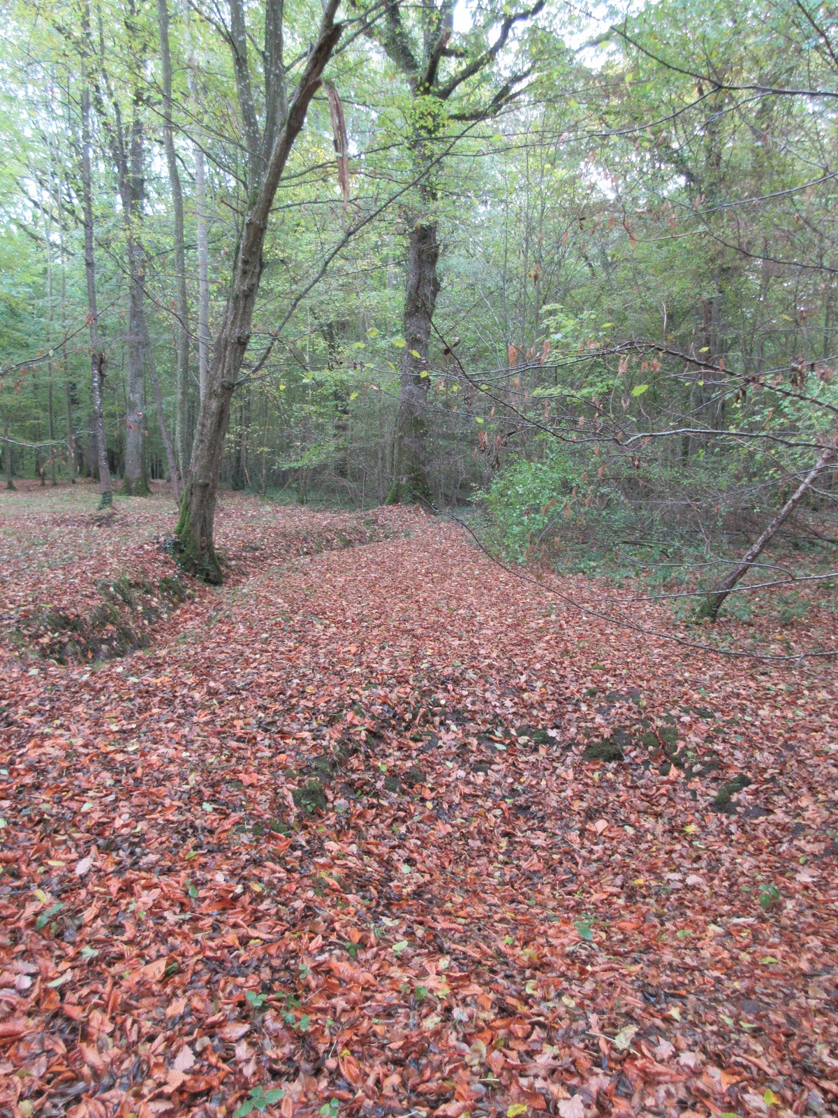
Fighting in dense woods, often at night and under artillery bombardments that included poison gas, Marines continued to push back against the Germans.

Trenches and an artillery crater at Belleau Wood, 100 years later.
              A German intelligence report from interrogated U.S. prisoners stated: “The various attacks by both of the Marine regiments were carried out with vigor and regardless of losses. The morale effect of our firearms did not materially check the advance of the infantry. The nerves of the Americans are still unshaken…. A characteristic of one of the prisoners is ‘we kill or get killed’.”[12] At Belleau Wood, the modern Marine Corps earned its stripes.
Stymied at the Wood, eight divisions of German soldiers tried to outflank the Americans east of Chateau-Thierry, but the 3rd Division repelled six successive assaults, earning the nickname, “Rock of the Marne.” In this action, the 3rd suffered 3,401 dead and 12,764 wounded. The Allies then went on the offensive and eliminated the German salient by August 6th. Ten American Divisions (310,000 men) participated in this offensive. The repulse of the Germans and the subsequent Allied offense along this front cost U.S. forces 67,000 casualties.[13]
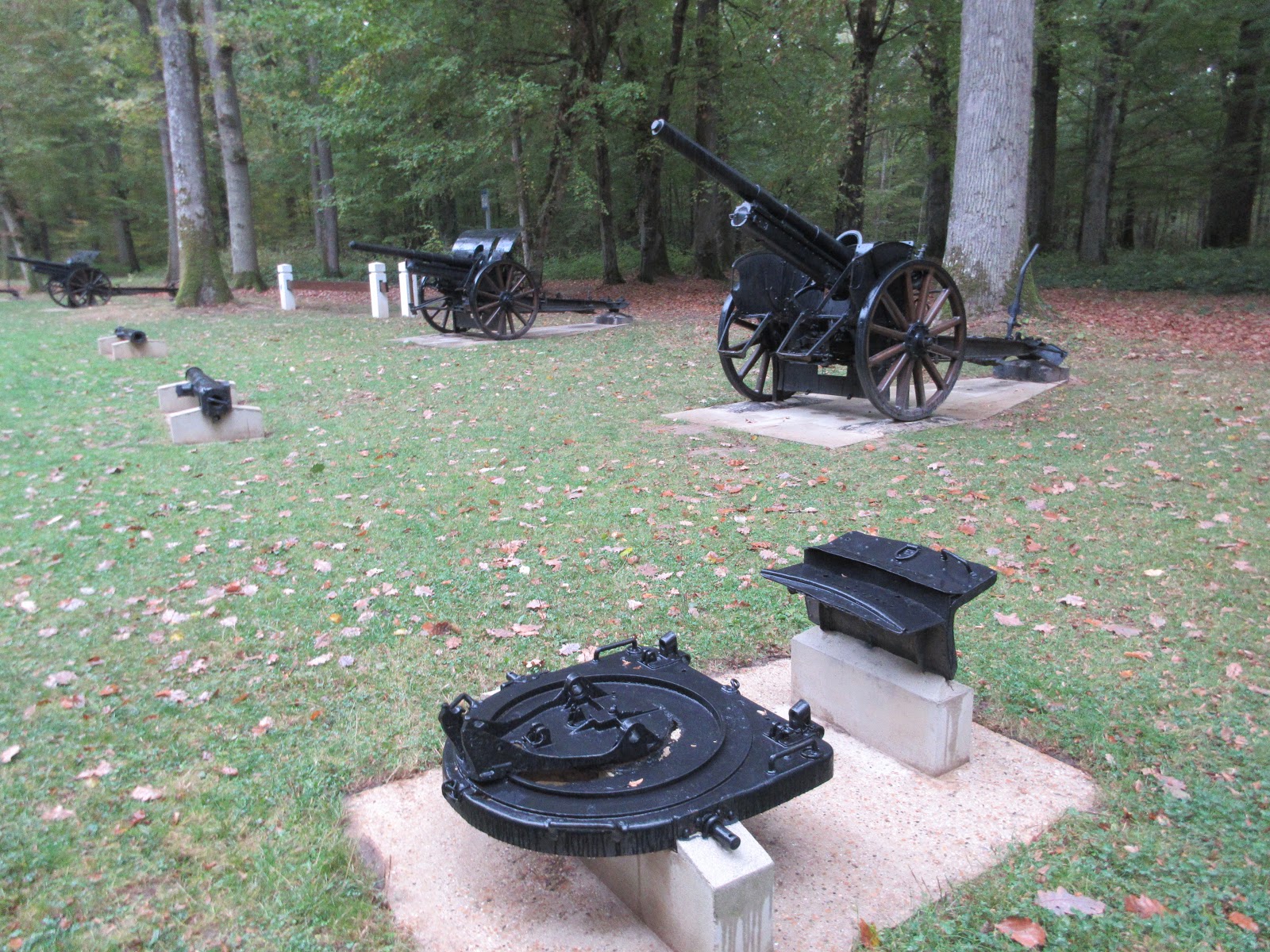
Superintendent Burtelson then took us to a room where he showed us bullets and shrapnel that the ground keepers had recently collected in the forest. He passed around a two foot long piece of mangled shrapnel that weighed about fifteen pounds. If it hit a person, it would tear apart a body. Then he said that military divisions aren’t buried at the cemetery, that men are, and he took us to his office to talk about a couple of the men who died at Belleau Wood.
Holding up a copy of a death certificate, he said that he talks to the dead. He researches those who died by reading documents obtained from military records. He introduced us to John (Chick) Havden, who died in Belleau Wood but whose grave is unknown. Some 1,000 slain men were never recovered from this battle. Then he showed us a photo of Jim Dean, a fifteen year old who enlisted by lying about his age. We read a letter to Dean’s mother from someone who witnessed his death. Dean was second in line on a patrol winding their way through the dark woods around 2:30 am. They were wearing gas masks to protect themselves when a machine gun burst killed the first man in the line who was the bugler and then Dean. The letter assured his mother that he died instantly without suffering. Superintendent James said that most letters assured such a painless death although many men died in horrible ways.  
The Ainse-Marne American Cemetery, France.
As the Allied troops advanced toward Germany, the Germans called for peace. In a clearing surrounded by woods outside of Compiègne, the French, British, and Germans met in Foch’s railroad parlor car to end the war. At the Armistice Clearing, the belligerents signed a temporary halt to hostilities that took effect on the 11th minute of the 11th hour of the 11th day of the 11th month in 1918. We now call it Veterans’ Day; however, the British call it Remembrance Day and the French Armistice Day. The railroad tracks that brought the opposing sides to the meeting, the statue of Foch that guards the clearing, and a railroad car similar to the one where the Armistice was signed still reside there.
              The Treaty of Versailles, signed in the Hall of Mirrors on June 28th, 1919, punished Germany, blaming it as the sole aggressor for the war. In truth many of the European countries were equally guilty. The treaty imposed excessively harsh war reparations on Germany and mandated its army be reduced to only 100,000 troops, with no tanks and airplanes. The German, Austria-Hungary, Russian, and Ottoman Empires all collapsed and even the overseas domains of Britain and France struggled in the economic devastations of the war. The map of the Middle East was redrawn by the victors which still impacts that region. 
Europe after the First World War. From World War II Museum at Caen, France.
              In the final reckoning, the harsh treaty that ended World War I begat World War II. Germans, reduced to poverty due to the war reparations and run-away inflation of the 1920s and 1930s, embraced a nationalist leader who railed against the punitive treaty and rose to power. We will return to the rise of Nazism in the chapter on the European theater in World War II.  
              In the U.S., President Wilson, hailed as a savior in Europe, returned from the peace negotiations to a hostile Senate which never ratified the Treaty of Versailles. His Fourteen Points, including self-determination for colonial people, an end to secret treaties, and the creation of the League of Nations, suffered first from unsympathetic Allies who wanted revenge against Germany, and then from recalcitrant U.S. senators from both parties who objected to parts of the treaty. In campaigning to gain public support for it, Wilson suffered a stroke and served his last year in the White House disabled and isolated.
The 1,200,000 U.S. soldiers who engaged in combat for 200 days held a quarter of the Western Front. Of these soldiers, 117,000 were killed in action with 139,000 wounded or missing. Nonetheless, their contributions are recognized at the Chateau-Thierry Monument: “With many German units exhausted and 9,000 new American soldiers pouring into France each day, the balance had tipped.”[14] The United States’ entry into World War I proved decisive in the Allied victory.
In justifying the graphic images by the artists and photographers who documented the war, art critic Adeline Adams said: “It must be told, the pictured story of our country’s past in the World War…. We are of a forward looking habit; we have such a wealth of tomorrows on our mind that we forget our yesterdays, their glory and bitter cost.”[15] Remembering the horrors of the war and the young lives lost continues to be vital. In fact, in almost every French village, town, and city, a memorial lists the names of the local men killed. For example, on plaques inside the Cathedral in Versailles, I counted over 500 names that died from that parish alone. Often the names of those who also died in World War II are attached to a memorial, a reminder of how World War I led to World War II.

World War I consumed not just Europe, but battles raged in Africa, the Middle East, and Asia. The human cost dwarfed previous wars with 9,500,000 military deaths, 21,000,000 wounded, and 4,000,000 prisoners or missing[16]. In this increasingly mechanized war, most casualties came from artillery, machine guns, and poison gas. For civilians, some 13,000,000 died from starvation, massacres, or as collateral damage. An influenza epidemic towards the end of the war killed an additional 20,000,000 and 50,000,000 people worldwide.[17] The Great War ushered in a new type of combat which destroyed millions of young lives as well as the old world order. The twentieth century never quite recovered from it.

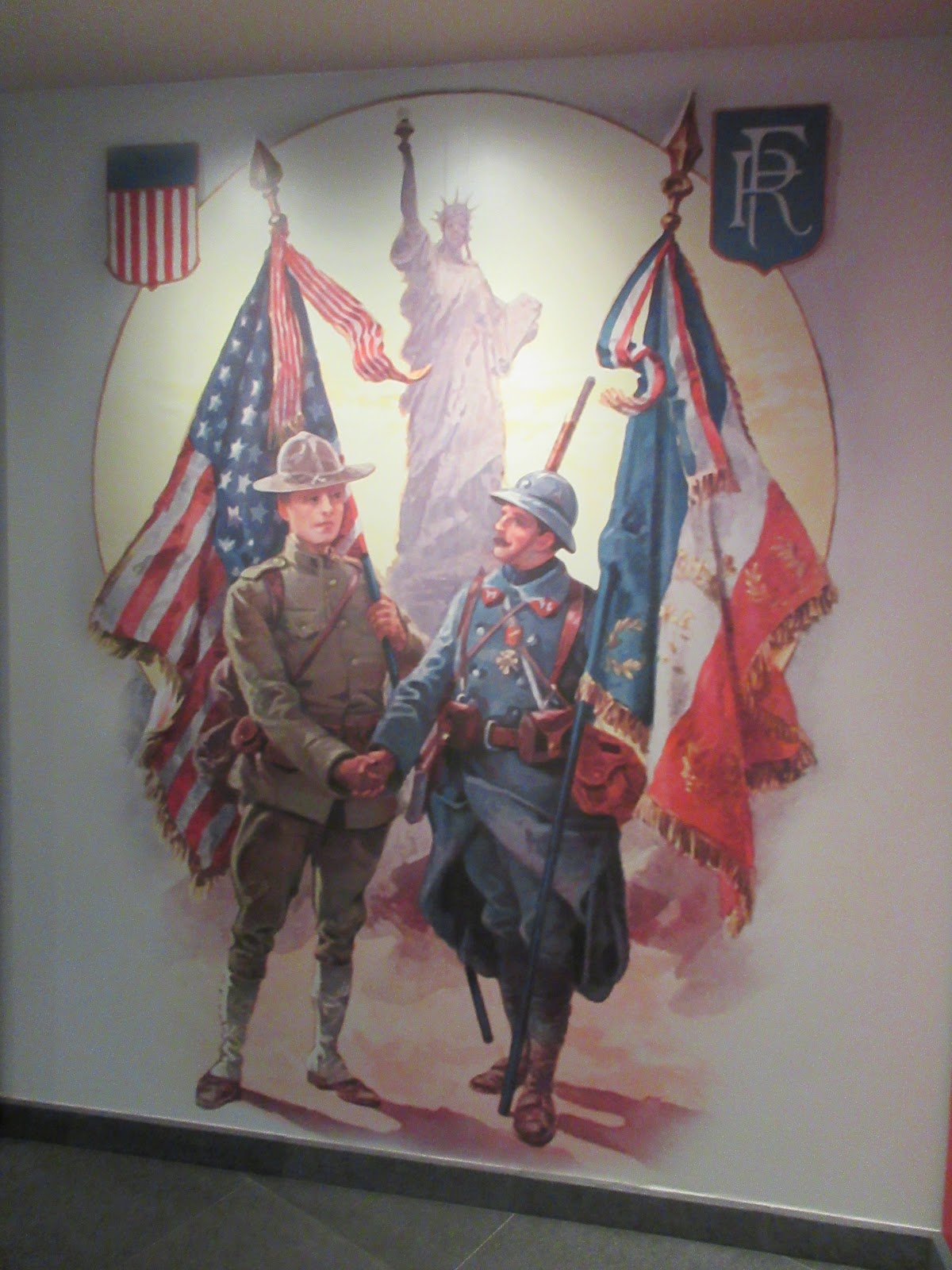
The Pershing-La Fayette Monument was erected in 1937 by France which “symbolizes the mutual gratitude of the two nations for the help each gave to the other in their struggle for freedom.”[18] The Chateau-Thierry Monument was dedicated in 1929 to commemorate the American contribution to stopping Germany’s last offensive in the summer of 1918. The Aisne-Marne and the Oise-Marne American Cemeteries are managed by the American Battle Monument Commission which Pershing directed after World War I. The Armistice Clearing was constructed in the 1920s, and Arthur Henry Fleming, an American industrialist, financed the museum there which opened in 1927. Hitler used the clearing and the railroad car where the armistice was signed to stage the abdication of France in 1940. The Nazis destroyed the museum that year, which was reconstructed in 1950. The U.S. National World War I Museum in Kansas City was opened in 1926.
From the exhibit at the Chateau-Thierry Monument, France.
Armistice Clearing and Museum
60200 Compiègne, France
+33 3 44 85 14 18

Aisne-Marne American Cemetery
02400 Belleau, France
+33 3 23 70 70 90
Chateau-Thierry American Monument
This monument is managed by the Aisne-Marne Cemetery.

Oise-Aisne American Cemetery
02130 Seringes-et-Nesles, France
+33.(0)3.23.82.21.81

National World War I Museum and Memorial
2 Memorial Drive
Kansas City, Missouri  64108
(816) 888-8100


[1] Exhibit text at Chateau-Thierry American Monument, France.
[2] Exhibit text at Chateau-Thierry Monument.
[3] Exhibit text at the Armistice Memorial Museum, Compiègne, France.
[4] Exhibit text at the Armistice Museum.
[5] Yann Thomas, World War I: From Mobilization to the Armistice (Bayeux, France: OREP Editions, 2017), 11; exhibit text at Musée de l’Armée—Invalides, Paris.
[6] Thomas, World War I, 15.
[7] Thomas, World War I, 16.
[8] Exhibit text at the National World War I Museum and Memorial, Kansas City, Missouri.
[9] Exhibit text at Chateau-Thierry Monument.
[10] Exhibit text at Chateau-Thierry Monument.
[11] Exhibit text at Chateau-Thierry Monument.
[12] Report from the German IV Reserve Corps intelligence officer, accessed at Aisne-Marne Cemetery, France.
[13] Conversation with James Burtelson, superintendent at Aisne-Marne Cemetery; exhibit texts at the Chateau-Thierry Monument and the 3rd Division Memorial in Chateau-Thierry; American Battle Monuments Commission brochure for Aisne-Marne American Cemetery and Memorial.
[14] Exhibit text at Chateau-Thierry Monument.
[15] Exhibit text at Chateau-Thierry Memorial.
[16] Exhibit text at Musée de l’Armées—Invalides, Paris.
[18] Exhibit text at the Pershing La Fayette Monument, Versailles, France.

Sunday, November 11, 2018

The End of World War I

The Aisne-Marne American Cemetery.
Today is the 100th anniversary of the end of World War I. On the 11th minute of the 11th hour of the 11th day of the 11th month in 1918, the Great War came to an end. Some now call it the Armistice Day, others the Remembrance Day, and others still Veterans' Day. Whatever you call it, the end of this most horrific war in human history to date had killed 10,000,000 young men and wounded an additional 6,000,000. Millions more civilians got caught in the fighting or died from starvation. Many of those who survived had lost their youth and dreams.

Earlier this month, I was privileged to visit some of the cemeteries, battlefields, and memorials to the American forces who fought in France. Since our president canceled his trip yesterday to one of the places I visited, I offer here some photos to show what he missed in his apparent disrespect to those fallen in battle.

Some of the 2,288 graves at the cemetery.
Inside the chapel at the cemetery are the names of the 1,060 of those men who died here but whose bodies were never found.

Above the cemetery, the Belleau Wood battlefield was where the 5th Marines rushed in to the stop the German advance on Paris in the summer of 1918. Over a month of fierce combat amidst relentless artillery and gas attacks, U.S. forces halted the German breakout and turned the tide of the war. 

German artillery captured in Belleau Wood.


After 100 years, the scarred landscape of the forest still show a bomb crater in the foreground and a hastily dug trench on the upper left.

The path through the woods skirts a trench dug in the summer of 1918.

Next week, I will post some more photos of my visits to the cemeteries and memorials to the U.S. participation in World War I.


Monday, December 19, 2016

Hanging up the keys and sitting down at the computer

For those of you expecting a new blog, here is a reprint from the end of last week's.

This is my last blog. I have decided that I now need to shift my writing and focus to a book about the history of the U.S. from those places that I visited where history actually happened. I can’t continue this weekly blog and also write the book. I have enjoyed writing for you and am a bit saddened that I have to pull the plug, but I can’t devote the time needed to the blog. I want to thank you for reading and following me and also thank those Parkgonauts and community history scholars that I met along the way. This has been a great way to spend seven months, visiting over 100 NPS and historical sites and driving 20,000 miles. If you still want to read my take on the NPS and historical sites, you can always revisit my earlier blogs.


I am still driven by history, it’s just that now I will drive my desk, researching and writing and making sense of my journey and our country’s past and present. Stay tuned—this is not the end of Driven by History. It is just the end of the road trip. The fun's over, now comes the real work—the book.

Monday, December 12, 2016

Goodbye to the Centenary of the National Park Service

As the year comes to a close on the Centenary of the NPS, so will my travels to our National Parks. The new year beckons with a new goal—turning this sabbatical of travel and blogging into a book. But first, here’s the last entry of “Notes from the Road.”
Aztec National Monument's central plaza (Photo by Hunner)

Last Monday, I left Durango and headed south to warmer climes. I visited Aztec National Monument, one of the places where people gathered after they left Chaco in the 12th century. A reconstructed kiva, the only such one in the National Parks, offered a great place to imagine dancers and drummers, priests and supplicants holding religious ceremonies. There, the walls echoed with a recording of such singing and drumming. Crouching through low doorways and walking around the ruins, I marveled at the window Aztec offered into the world of the Ancestral Puebloans. In the documentary film about Aztec at the visitors’ center, one of the Native American narrators commented about the transitory nature of the place. She said that her people have always been a migrating culture and that her ancestors left this and the other places that I have visited the previous week because it was time to move on. For me, this rings truer than drought, warfare, or other reasons offered by archeologists. Leaving Aztec NM, I drove through Farmington, Shiprock, and Gallup and hopped onto Interstate 40 to get to Grants at the base of the sacred mountain of Mt. Taylor.
Interior of the reconstructed kiva at Aztec (Photo by Hunner)
Grants has seen better days, evidenced by its closed restaurants and boarded-up stores. Perhaps it never recovered from the uranium mining boom of the 1950s and 60s with the consequential environmental and health challenges. I left Grants the next morning on my way to finally go to Sky City at the Pueblo of Acoma. I first stopped by El Malpais NHP just south of Grants where Ranger Dalton informed me that the Sky City is operating winter hours and is only open on weekends. So much for my advanced planning. So I quickly reorganized and headed for El Morro where over the centuries, people have carved names and symbols into the soft stone cliffs. From Native American petroglyphs to Don de Oñate’s “Paso por Acqui” (I passed by here) in the early 1600s to railroad surveying crews in the 1850s, El Morro has documented the many people who used the pond at the base of the cliffs for water in an arid land.
The cliffs of El Morro National Monument (Photo by Hunner)
The pond at the base of El Morro that has attracted travelers for centuries (Photo by Hunner)


Don Onate's signature at El Morro  (Photo by Hunner)
After marveling at this isolated outpost of the NPS and talking to volunteer Rob, I swung through the Pueblo of Zuni for a fill-up and turned south for Pie Town and U.S. 60. A quick coffee and some apple pie at Pie Town prepped me for a visit to the Very Large Array on the Plains of St. Augustine. Some might recall Jodie Foster in the opening scenes of the movie “Contact” in front of the large satellite dishes peering into space which was filmed at the VLA. At the site, scientists from around the world converge to listen to the full range of radio waves that emanate from stars, galaxies, and planets. Their research has changed our understanding of the universe. It was a great juxtaposition of the 21st century with the 12th century of Chaco and the other pre-contact Native American sites I had just visited.
The dish at the Very Large Array. Notice the line of the dishes that recede in the background (Photo by Hunner)
An example of the images of radio waves recorded by the VLA (From exhibit at the Visitors' Center)


I continued that Tuesday by stopping at the Bosque de Apache Wildlife Refuge south of Socorro, New Mexico. Here tens of thousands of Sandhill Cranes, Canadian Snow Geese, and various ducks winter.  At dusk, the cranes glide into a pond by the side of the road to spend the night protected by water from the predatory coyotes. As they flew overhead honking and softly landing in the ponds, avid birders with cameras the size of bazookas rapidly shot photos with the sunset in the background. I often stop by this time of year for some rejuvenation of the generosity and beauty of nature. I ended the day with a soak at Rivers Bend Hot Springs in Truth or Consequences on the banks of the Rio Grande.
Sandhill cranes settling in for the night at the Bosque. (Photo by Hunner)
Birders at the Bosque (Photo by Hunner)
So here’s the deal. This is my last blog. I have decided that I now need to shift my writing and focus to a book about the history of the U.S. from those places that I visited where history actually happened. I can’t continue this weekly blog and also write the book. I have enjoyed writing for you and am a bit saddened that I have to pull the plug, but I can’t devote the time needed to the blog. I want to thank you for reading and following me and also thank those Parkgonauts and community history scholars that I met along the way. This has been a great way to spend seven months, visiting over 100 NPS and historical sites and driving 20,000 miles. If you still want to read my take on the NPS and historical sites, you can always revisit my earlier blogs.


I am still driven by history, it’s just that now I will drive my desk, researching and writing and trying to make sense of my journey and our country’s past and present. Stay tuned—this is not the end of Driven by History. It is just the end of the road trip. Now comes the real work—the book.
Sunset at the Bosque de Apache (Photo by Hunner)

Monday, December 5, 2016

Notes from the Road, Dec. 4, 2016

As my sabbatical winds down and I start to wrap up my road journeys, I am taking a final spin through the Southwest. Since it is late November and early December, winter pops up its snowy head and changes plans. I wanted to first stop at Sky City at the Pueblo of Acoma, but it was closed due to some snow. So I went to Santa Fe instead (when in doubt, go to the City Different). In Santa Fe, I visited several interesting museums and something essential for any day trip to a museum, a good restaurant.
St. Francis Basilica in Santa Fe on a winter afternoon. (Photo by Hunner)
At the International Folk Art Museum on Museum Hill, I spent time going through a perennial favorite, the Girard Wing. Alexander Girard, a fashion designer in the post-World War II period, donated tens of thousands of folk art items that he and his wife collected over the years to the Museum of New Mexico. Dolls from the Underground Railroad, entire festival scenes with miniature figures from Italy, Mexico, Peru, and other countries, religious icons, carved figures from Africa, Asia, the Americas, all these folk art items testify to the ingenuity and wealth of culture that people around the world manifest in their lives.

Above, toy trains at the International Folk Art Museum. Below, street scene from the Girard Collection.
(Photos by Hunner)
After a nice lunch of albondigas soup and a tuna melt at the Museum Hill café, I then stepped into the Museum of Indian Arts and Culture. I enjoyed the exhibit on the path breaking Native American fashion designer, Lloyd Kiva New, whose clothes and women’s hand bags from the 1950s and 60s brought indigenous sensitivities to the mainstream. Another exhibit on Native American superheros and cultural symbols also testified to the new ways that the museum is interpreting native peoples and their lives.
Apache dancer sculpture outside the Museum of Indian Arts and Culture on Museum Hill. (Photo by Hunner)
The next day, I attended the “Fractured Faiths” exhibit at the New Mexico History Museum. Several years ago, I served as the interim director of that museum and worked on the early stages of the exhibit. It is an ambitious account of the effect of the Spanish Inquisition on Jews living first in Spain and then in other countries of Europe and the Americas. Some Spanish colonists who migrated to New Mexico were Crypto-Jews who wanted to get as far away from the Inquisition as possible while still living under Spanish rule. New Mexico fit that bill. Curator Josef Diaz collected an amazing set of artifacts from the U.S., Mexico, and Spain to illustrate the diaspora of Jews from Spain after 1492.

West of Santa Fe, a volcano erupted in north central New Mexico. Granted that happened 1,000,000 years ago. At around 30,000 feet above sea level, this gigantic volcano blew its top and scattered debris across five states. As a result, it wound up a mountain range only 12,000 feet high. This mega-volcano was many times more powerful than Mount St. Helens and layered the landscape with hundreds of feet of hot ash and rock that fused together to form tuff. Its remnants now comprise the Jemez Mountain Range. In the Jemez Mountains, three units of the National Park Service exist—the Valles Caldera National Historical Park, Bandelier National Monument, and one of the Manhattan Projects National Historical Parks at Los Alamos.
Cavates (cave dwellings) at Bandelier. (Photo by Hunner)
Bandelier is one of my all-time favorites parks in the NPS. It has abundant flora and fauna, its steep canyon walls provide a dramatic landscape, and the rich heritage evidenced by the reconstructed ruins of a multi-storied pueblo, cliff dwellings, and a long string of houses built at the base of a steep canyon wall vividly evoke a civilization distinctly different than ours. Bandelier opens a portal to Puebloan culture, past and present.
Pueblo ruin of Tyuoni at Bandelier. (Photo by Hunner)
At the Visitors’ center, an exhibit quotes many Native Americans and their relationship with Bandelier. Here is one from the Affiliated Pueblo Committee: “Spiritually, our ancestors still live here at Bandelier. You see reminders of their presence here—their homes, their kivas, and their petroglyphs. As you walk in their footsteps, value the earth beneath you and show everything the same respect we do when we re-visit this sacred place.”[1]

Walking in their footsteps is amazing. The main loop trail of a mile passes through the pueblo ruin of Tyuonyi, by the cavates (caves where they lived and worshipped), and along the half mile Long House where two and three story houses were built against the base of the walls of Frijoles Canyon. The soft tuff rock is ideal for shaping blocks with stone tools as well as absorbent of precious water in their fields and heat in the cool summer nights and cold winter days. When I was there in early December with the temperature around freezing, I warmed myself next to the light colored south facing cliff walls.
Long House with the ruins of multiple rooms built against the cliff (Photo by Hunner)
The Ancestral Puebloan people who lived here in the 13th to 15th centuries immigrated from the Four Corners after the collapse of Chaco Canyon and its outlier settlements. They farmed the Three Sisters of corn, beans, and squash in waffle or grid fields. They hunted deer, elk, bear, turkey and other animals. They made pottery, wove clothes from cotton and yucca fibers, and carved petroglyphs on the canyon walls. We have a wealth of information about the people of Bandelier since archeologists have worked here for over a century and a quarter.

On the same day, I went to Los Alamos and one of the newest additions to the NPS—the Manhattan Project National Historical Park. Ranger Kirk Singer enthusiastically welcomed me to the small office in the center of town and shared the future plans to walk in the footsteps of our 20th century ancestors to changed history by unleashing the power of the atom.
Ranger Kirk Singer at the Manhattan Project National Historical Park. (Photo by Hunner)
I next left Santa Fe, and I revisited Chaco Canyon, one of my other all-favorite parks. In my experience, Chaco is the hardest park to get to in the lower Forty-eight states. Its twenty some miles of dirt roads, including the last four of bone jarring ruts and mud is well worth the effort. For 350 years-- from 800 to 1150 C.E.—a complicated civilization there built massive multistoried structures and a far flung road system, made exquisite pottery, and developed a precise knowledge of the solstices, equinoxes, and lunar stand stills.  Just one example of the incredible engineering and architectural expertise of the Chacoans—Pueblo Bonito was the largest built structure in the United States until the 1920s.
Pueblo Bonito at Chaco Canyon (Photo by Hunner)
Ranger Jackson Lincoln giving a tour at Pueblo Bonito. (Photo by Hunner)
Their kivas had foot drums that people danced on to aid in the ceremonies. Like at Bandelier, Native Americans view Chaco as a place where their ancestors still live. For all of us, it communicates a universe and world view and is like a foot drum that amplifies the Ancestral Puebloan peoples’ times. I wrote about Chaco in an earlier blog if you want more information.
Grand kiva at Pueblo Bonito. Notice rectangular foot drums on floor of kiva. (Photo by Hunner)

Cliff Palace at Mesa Verde. (Photo by Hunner)
Finally this week, I drove to Mesa Verde National Park. This also preserves the buildings and cultural remains of Ancestral Puebloan people in the Southwest. Set amidst steep canyons in southwestern Colorado and tucked in caves along the cliffs, Native Americans lived here in the 13th century. Connected to the Chacoans, the inhabitants of Mesa Verde continued a vibrant culture and understanding of the world around them. It fascinates with a silent tribute that speaks volumes.
Square Tower at Mesa Verde. (Photo by Hunner)
As I mentioned in a past posting, I am now struggling with how to turn this trip and these blogs into a book about the history of the United States from those places where history actually happened. If you know of any publishers or agents who might be interested, please let me know.

In the meantime, I am giving two lectures in the coming weeks about my travels. On Monday, Dec. 12th, I will offer Celebrating the National Parks: A Centennial Birthday Journey  for the Southwest Seminars series in Santa Fe. Thanks Connie and Alan for including me in this series. Then on Thursday, Dec. 15th in Las Cruces, I will give a lecture about my road trip for the Academy of Learning in Retirement. This will be the last in a series of four lectures beginning on Dec. 6th with Dr. Pete Kopp talking about the parks before the creation of the NPS, Dr. Dwight Pitcaithley on Dec. 8 going into the parks in the twentieth century, Dr. Carol Campbell presenting on the ecology of the parks on Dec. 13th, and me on the 15th. Come hear these illustrated presentations about our National Parks as we finish our celebration of the NPS.
Kin Kletso at Chaco Canyon (Photo by Hunner)


[1] Quote from Visitors’ Center exhibit at Bandelier NM.

Monday, November 28, 2016

How war deaths affect families

Most of the blogs for Driven by History the last month or so have focused on the Civil War. In addition to recounting the individual battles like Manassas, Shiloh, and Antietam, I have written on other issues, such as battlefield surgery and medicine, cannons, and riverboats. This posting will be a bit different since I won’t take up a particular battle but will talk about how fatalities affected those family members left behind. I don’t have ancestors who fought in the Civil War, but I do have some who fought in World War II. So, to look at the impact on family survivors, I will dive into my own past and explore how a combat death had a generational ripple effect which impacted people not yet born.

I have a black and white photograph taken in the jungles of Philippines. My brothers and I uncovered it as we divvied up the boxes of photos left over from Mom’s life. On the right in the photo is Capt. Daniel S. LaShelle in slouch hat and crumpled fatigues. He stands tall and slender with dark circles under his eyes. In his left hand burns a cigarette, and a wedding band glows on his ring finger. The ring joins Dan and Anna Jane, my mother, together. I never met Dan, my almost father.

Next to Dan stands a Filipino. He comes up to Dan’s shoulder with his bushy hair. Perhaps Dan has just given him a cigarette. Two more are tucked behind his right ear. He holds a machete at a downward angle in his right hand and carries several bags over his shoulders. A scarf wraps around his neck and bare torso, shorts hang loosely off his hips. Anklets ride above his bare feet.

To Dan’s right stands another GI with hands on hips, smiling at the camera. They are in the middle of a muddy clearing, surrounded by tall palm trees. This is early 1945, on the island of Luzon, as the U. S. Army wrestled back the Philippines from the Japanese. Dan served as a Captain in the 1st Infantry 6th Division.

I recorded an oral history of Mom about her World War II experiences in May 1990. In the interview, she talked about dropping out of the University of Kansas to work in an airplane factory in Kansas to support the war effort. While in Kansas City, she met Dan in the summer of 1942. They married in May 1943 and both went to San Luis Obispo for his military training.  She rented a place at Morro Bay with black-out curtains, and “Dan could come home most nights.” On some mornings, they walked along the nearby beach looking for any footsteps from infiltrating Japanese. In August or September of that year, she and the other wives drove up to San Francisco and watched the troop ships steam under the Golden Gate Bridge on their way to the war in the Pacific.  Neither Dan nor Mom knew where he was headed.

I asked “What was your feeling?”
She replied: “We didn’t have… so what do you think? We thought of course that we’d see ‘em,”
She drove back to Kansas and worked at Boeing in Wichita in the industrial engineering division in final assembly. She worked ten to twelve hour shifts in the factory that ran twenty-four hours a day making B-29s, the new Superfortresses that devastated America’s enemies in Europe and the Pacific. She worked at Boeing from January 1944 to February 1945.

On January 9th, 1945, the 6th Army landed at the Lingayen Gulf to fight their way south to Manila. In early February, Mom drove up to Junction City, Kansas to visit Dan’s parents. On her way back to Wichita, she stopped to see some friends in Salina. Her father tracked her down at her friends’ house and called her to say that the Western Union had a telegram for her and would only deliver it to her. He met Mom and Uncle Elmer Reed halfway between the two cities, about forty-five miles north of Wichita. They went straight to the Western Union office. The first telegram said that Dan was wounded. A second one several days later confirmed that he had died. She recalled: “He was wounded on [January] 24th and died on the 28th.”

My childhood memory comes into play. I remember Mom telling this story: one of Dan’s men in his unit, possibly the Filipino scout in the photo, was hit by a Japanese sniper. Dan crawled out to rescue him and was shot. He was officially listed as DOW—died of wounds. As the second telegram confirmed, he died several days after getting shot.

In the interview, Mom remembered that by the time she received the second telegram, she had gotten calls from several of the wives that she knew from San Luis Obispo. They had gotten letters from their husbands that said that Dan was killed. So Mom knew before she was officially notified by the War Department. Dan had been in the Philippines for two weeks.
           
I found a letter in Mom’s files from the Army to Mrs. Anna J. La Shelle, dated March 8, 1945. I found it as I prepped for my Introduction to U.S. History survey course. I had slipped the letter in my World War II file. In the letter, Major General C. H. Danielson wrote to Mom: “The War Department has informed me that your husband, Captain Daniel S. La Shelle, has given his life in the performance of his duty. It is therefore with deep sympathy that I address you in behalf of this Command and extend every possible comfort and assistance.” Gen. Danielson suggested that Mom contact a “Personal Affairs Officer in the vicinity” in Wichita, avail herself of any assistance such an officer has available, or contact the nearby Red Cross office “to provide counsel and assistance.” He concluded: “I hope that the passing days will bring you comfort and a consoling pride that your husband gave up his life to set men free. His name will be honored one among all who were privileged to know him.” I show this letter to my history classes as an example of the sacrifice and tragedy of the war.

In my oral history with her, Mom talked about how devastated she was, how she spent weeks crying in her room, and then how her father put her in his car and drove her back to the Chi Omega House in Lawrence. In the embrace of her sorority sisters, she began to return to the living although she never fully recovered.

After the interview, I went off to the store to get some things for dinner. Mom turned the tape recorder back on and added something to the interview. Later that evening, I listened to her addendum. She said: “That was so painful, losing Dan. I didn’t want to hurt that bad ever again, so I resolved never to love anyone again.” Many people loved Anna Jane throughout her life. She loved many people in return, but perhaps not very closely. For me, Mom had a hard time loving those close to her, a consequence of Dan’s death in World War II. 


Mom had lost her first husband. Dan La Shelle was one of the nearly 14,000 U.S. casualties in retaking the Philippines. My Dad, Paul Hunner, also fought in the invasion in 1944-45, and lived. I am here to tell the tale of my family because he survived, and Dan did not. So I bear witness to the effects of war deaths and combat injuries that last far beyond the immediate moment. They outlive even the survivors. World War II, the Civil War—these and all wars impact those combatants who survive, those who fight on the home front, and the children of the combatants. The story of Anna and Dan is repeated throughout the ages. It is also the story of war.  

Monday, November 21, 2016

Antietam National Battlefield, Sharpsburg, Maryland

As with almost all the Civil War battlefields preserved by the National Park Service, Antietam lies serene with its well-maintained fields and copses of trees. The place bears no resemblance to the ferocious place of death and destruction in 1862. To this day, Antietam remains the single bloodiest one-day battle in our nation’s history, worse even than D-Day or Iwo Jima in World War II. The Confederate defeat here ended Lee’s first invasion of the North and set the stage for Lincoln to issue the Emancipation Proclamation. Like other battlefields, Antietam place bears silent witness to the thousands of men killed in the savage fighting in these hills, swales, and streams.
The battlefield at Antietam  (Photo by Hunner)
Lee invaded Maryland for several reasons: first, he wanted to rattle the North by taking the war to their homeland. Second, the rich farmland of Maryland beckoned as a cornucopia. Third, a successful invasion might open the door to foreign recognition of and support for the Confederacy.

The South’s victory at Second Manassas opened the route north. Lee’s plan called for the Army of Northern Virginia to split in two, with General Stonewall Jackson’s troops going to Harper’s Ferry and the rest heading farther north. However, the Union forces at Harper’s Ferry held out longer than expected. Complicating the invasion, Union soldiers found Lee’s secret battle orders in a muddy field, wrapping three cigars, but Union General McClellan failed to exploit Lee’s divided army. The invasion stalled near the town of Sharpsburg, and Lee considered retreating to Virginia until news reached him that Harper’s Ferry had finally fallen. With those Confederate troops now free to rejoin his army, Lee braced for battle with nearly 30,000 troops. McClellan’s army held 60,000 men with another 15,000 in reserve nearby.
General Robert E. Lee (From exhibit at Antietam's Visitors' Center)
The Battle of Antietam took place in three phases. First, at the Cornfield and the North Woods at the north end of the battlefield, the armies clashed with ferocious intensity. Then as the Northerners pressed in from the east, the Confederates regrouped in a sunken farm road afterwards known as the Bloody Lane. And finally at the southeast part of the battlefield, just when it looked like the North would crack the Confederate right, more Southern reinforcements rushed from Harper’s Ferry shored up their defenses. As Civil War historian James McPherson notes: “The fighting at Antietam was among the hardest of the war.”[1]

When I visited Antietam at the end of August, I sat behind the Visitors’ Center looking out over the battlefield as Chief Ranger Keith Synder sketched out the action. The first phase of the battle took place over five hours during the morning of September 17, 1862. Wading through a ripened corn field, five Union divisions slammed into five Confederate divisions which resulted in 12,000 men dead or wounded. The combat so shattered these divisions that they backed off, and few of those survivors rejoined the fighting that day.

By midday, the battle had shifted to the center of the lines as Confederate soldiers ducked into a sunken road to resist the Union onslaught at the Bloody Lane. After a determined resistance, this fell to the advancing troops in blue. A northern war correspondent who arrived right after the Union captured the road commented: “Confederates had gone down as the grass falls before the scythe.”[2] Those who escaped fled to nearby Sharpsburg to regroup.

General Burnside commanded the Union left on the southeast section of the battlefield. As a divisionary action, he tried to pin down Confederates so that they could not reinforce the fighting to the north. Instead, the Georgia troops on a hillside above a strategic bridge devastated the squads of Union soldiers who tried to rush across. After many delays, the Union took the bridge and also forded the Antietam Creek at nearby fords and forced the Southerners back.
Burnsides' Bridge from the rifle pits that the Georgians used to pick off the Union soldiers as they tried to cross it.
(Photo by Hunner)
Just when it seemed that the Union troops were going to roll up the Confederate right flank, General A.P. Hill’s men arrived from Harper’s Ferry and blunted the North’s advance. The next day, both sides stayed in the area without any major engagements. Each side had suffered much in the one-day battle—17,000 wounded and 6,000 dead or dying. Nearly one-third of the Confederates who marched north became causalities. Both sides reeled from such losses, which perhaps explains why McClellan failed to capture the exhausted Southern army which retreated to Virginia.

The number of dead and wounded shocked the public. The toll was horrendous—as McPherson says: “The causalities at Antietam numbered four times the total suffered by American soldiers at the Normandy beaches on June 6, 1944. More than twice as many Americans lost their lives in one day at Sharpsburg as fell in combat in the War of 1812, the Mexican War, and the Spanish American War combined.”[3] As the Civil War intensified, the body count mounted.
A Confederate cannon facing towards Burnsides' Bridge in the southern part of the battlefield
(Photo by Hunner)

One of the most lethal weapons on the Civil War’s battlefields was artillery which constituted its own branch of the army. Well placed cannons anchored an army’s position and blunted enemy attacks. 
Effective use of artillery required a well-trained set of soldiers and horses. A battery consisted of four to six guns manned by seventy to one hundred soldiers. Each unit consisted of a cannon, one or two limbers which carried between thirty and fifty rounds of ammo each, and a caisson with spare wheels and more ammunition. The limbers and caisson held between 120 to 200 rounds. The cannon, limber, and caisson in various combinations were pulled by six or more horses which made these weapons quickly responsive to a fluid battlefield.
Caisson and limber for a Civil War cannon (From Civil War Trust website) 
A cannon crew consisted of seven men. Four surrounded the gun with the Gunner in charge of aiming and giving commands. The other three at the gun washed and cleared the bore after every shot, rammed the ammunition and shell down the barrel, primed the powder bag, and lit the fuse or pulled the lanyard to fire the weapon. The final three in the crew ran ammunition from the caisson and limber (which were detached behind the cannon) to the gun and prepared the charges and fuses.

Two types of cannons blasted away during the war. Smoothbore guns fired round cannon balls. Rifled cannons had grooves cut inside the barrels which gave a spin to the fired round and proved more accurate. The range of many of the cannons at Antietam was around one mile.

These guns used four types of ammunition depending on the target. Smoothbores fired round shots while the rifled cannons used shells that looked like large bullets. Some ammo were solid projectiles while others had a fuse that exploded at its destination and scattered shell fragments. Case ammunition consisted of a shell packed with small balls that scattered once the fuse detonated while a canister shot contained golf ball size iron balls. Canister was used at close range—when soldiers were 100 to 300 yards away. Sometimes, the guns fired on opposing batteries to disable their enemy’s guns. Often however, cannons focused on charging infantry to disrupt advances.[4]

At Antietam, more than 500 cannons spewed lethal metal into the opposing side. Over 3,000 rounds per hour were fired, creating such a booming that “soldiers described the day as a ‘savage continual thunder’ and a ‘tumultuous chorus.’”[5] The effect of cannon balls, shell fragments, case, and canister on the human body was devastating.

As the Confederate army retreated, and the Union forces maneuvered to protect D.C., President Lincoln used the Union’s victory as an opportunity to issue the Emancipation Proclamation. On September 22, he issued a preliminary order which declared that on January 1, 1863, “all persons held as slaves within any state, or designated part of a state, the people whereof shall be in rebellion against the United States, shall be then, thenceforward and forever free.” This executive order focused on slaves in the Confederacy, but obviously, few if any were at first freed. The Emancipation Proclamation also opened the door to Blacks serving in the military of the United States.


The Proclamation changed why the United States fought. Prior to issuing it, Lincoln said: “My paramount object in this struggle is to save the Union and is not either to save or destroy slavery.”[6] On January 1, 1863, the reason for fighting officially shifted to ending slavery on the continent. Slaves did free themselves by escaping from plantations and walking to Union camps or the north. It would take another two and a half years of war to defeat the Confederacy and end slavery. Next week, I will explore the impact that war deaths have on those left behind while in future weeks we will visit Chattanooga and the other battlefields in the Civil War. Having said this, I am now finishing up my sabbatical and road trip. I am not sure how much longer I can continue to post a blog every week, especially once I start teaching again in January. I am also figuring out how to turn this into a book. Please let me know any ideas you have about both my blog as well as what you would like to see in a book. 

Cannon at Antietam (Photo by Hunner)


[1] James McPherson, Battle Cry of Freedom (New York: Oxford university Press, 1988), 540.
[2] McPherson, Battle Cry,” 541.
[3] McPherson, Battle Cry of Freedom,” 244.
[4] “Artillery at Antietam.”
[5] Keith Snyder, “Artillery at Antietam,” a brochure published by the Western Maryland Interpretive Association.
[6] George Tindall and David Shi, America: A Narrative History, (New York: W. W. Norton  & Company, 1984), 720.