Translate

Monday, June 6, 2016

The Oregon National Historic Trail

Oregon National Historic Trail from Independence, Missouri through Nebraska, Wyoming, Idaho, and Oregon.

On our Interstate highways, we easily drive as many miles in one day as the travelers along the Oregon Trail struggled to cover in a month. From Independence or Westport on the Missouri River to the Willamette Valley in Oregon, this 2,170 mile route challenged even the most hardy emigrants. The slow pace, the dusty and rocky road, the dangerous fords and high passes, the monotonous daily grind of hard work, the physical discomfort and death, all of these factors challenged the men, women, and children who set off for a new life in Oregon Country.
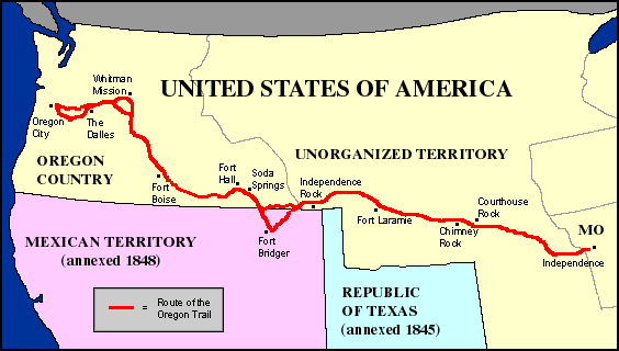
Map of the Oregon Trail (www.historyglobe.com)
Native peoples have lived in this region for over 10,000 years. By the turn of the 19th century, some of the tribes who called it home included the Nez Perce, the Walla Walla, the Cayuse, and the Warm Springs. Europeans first became attracted to the land for its fur, and trappers and traders working for the English Hudson’s Bay Company started taking beavers in the area in the early 1800s. In response to the rich trade, the Hudson’s Bay Company established an outpost at Fort Vancouver in 1824. Missionaries followed the mountain men, and then farmers sought the fertile Willamette Valley. By 1830s, the first settlers arrived and in 1843, more than 1,000 emigrants braved the six month journey. More soon followed. In 1852 alone, 50,000 emigrants traveled the Oregon Trail. From 1840 to 1880, approximately 300,000 people made the trek. This transformed the region.
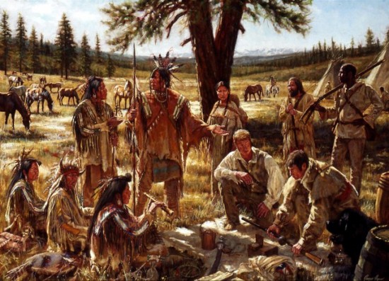
Nez Perce trading with Mountain Men (James Ayers Studios)

Reasons to Emigrate

Why leave the U.S. in the 1840s? A financial panic in 1837 devastated the economy, and disease (especially malaria and cholera) plagued the Mississippi River Valley. Oregon boosters back east extolled the virtues of the Willamette Valley with one man claiming that pigs ran around fully cooked with knives and forks already stuck in them, ready to eat. To such fanciful tales, those looking for an easier life flocked to the Oregon Trail starting points on the Missouri River.

Oregon Country was contested territory, lived in by Native Americans, and claimed by both the British and the Americans. Even before the 1846 treaty with Britain established U.S. ownership, emigrants started pouring into the territory. The massive influx of European Americans disrupted tribal communities and lives. Exchanges occurred as Native Americans traded with and aided the travelers, sometimes giving them salmon, their first taste of that nutritious and sacred fish. Without such aid, some pioneers would have died.

The Indians also protected their ancestral lands and ancient ways of life, sometimes with force. Treaties with the United States, sometimes abided by, sometimes not, forced them onto reservations. Massacres happened, like at the Whitman mission in 1847, and battles occurred, like with the Nez Perce’s attempt to escape forced relocation onto a reservation in 1877. Their epic 1,170 miles (1,880 km) flight across four states is preserved by the Nez Perce National Historic Trail. The legacy of contact and conquest continues to impact the native peoples of the region.

Traveling on the Oregon Trail

From the dairies of the emigrants, we learn of their trail hardships. One woman wrote that she had passed twenty-one graves that day. Death came on the trail in many ways. Some died from accidental gunshot wounds, others from being run over by a wagon. Deadly illnesses like cholera swept through the parties, since water holes were scarce at times and polluted by earlier sick people or animals.  Attacks by Native Americans defending their lands or hunting grounds did happen; however, few pioneers died from such exchanges. In a study by trail historian Robert Munkres of sixty-six trail diaries written before 1860, he found nine eyewitness accounts of hostile attacks.[1]

Trail travel tested everyone. Emigrants gathered at Independence or Westport near Kansas City in the spring. Using techniques perfected on the Santa Fe Trail for prairie traveling (see the posting from May 16), most trains left in late April or May. By then, the prairies had started to green up with fodder for their draft animals, and the land had dried out from the winter and spring precipitation.

Traveling on the Oregon Trail was not like driving the Interstate today. The historic trails were braided, with multiple routes to a destination. Since a wagon train might have up to 100 wagons, they sometimes traveled four or five abreast. Or a group might split off and seek an alternative route which they heard was better. Deep ruts of the historic trails still exist, carved into the landscapes by the iron rimmed wheels and plodding hooves of draft animals. At those places today, often at isolated sites with a stiff wind bending the sage brush, I can still hear the creak of the wagons, the groan of the overloaded axles, and the complaining moans of the oxen. At places like this, the past comes alive.
Wagon on the trail rut near the National Historic Oregon Trail Interpretive Center, Baker City, Oregon
(Photo by Hunner)
The best animals to pull wagons loaded with 2,000 pounds of goods were oxen, slow but hardier than horses or mules. For the six month journey, families stocked up with 200 pounds of flour, 150 pounds of bacon, and other food essentials. They also loaded up their household goods like furniture and stoves, clothes, and farm tools and seed stock.
Exhibit at the National Historic Oregon Trail Interpretive Center, Baker City, Oregon
(Photo by Hunner)
From Kansas, the trail went through southern Nebraska along the Platte River, past Chimney Rock and Scottsbluff and then into Wyoming. Fort Laramie offered respite, supplies, and a sense of protection from the imposing prairies.  As the Rocky Mountains loomed to the west, the next major point was South Pass, a surprisingly gentle path through the mountains. Once over South Pass, the emigrants passed the point of no return; however, the hardest part of the trail lay ahead.

Winding through the mountains of the West proved hard. Long stretches without water (and when found, might be tainted by dead animals), clouds of dust thrown up by the many wagons in a train, graves on the side of the trail, all these wore down the travelers. Daily routines started before daybreak with cooking the day’s food using dried cow chips for fuel, taking care of the livestock, yoking the oxen up, then walking fifteen or twenty miles -- often until dark. Few people rode in the wagons to avoid burdening the oxen further. Next day, repeat the same routine -- for six months or more.
Worn out travelers on the Oregon Trail (Photo at National Historic Oregon Trail Interpretive Center, Baker City, Oregon)
I caught the Oregon Trail in eastern Idaho at Soda Springs. I jumped on and off Interstate 84 through Idaho and Oregon at places like Glenn’s Ferry where the emigrants first encountered the Snake River, a tributary of the Columbia River. Glenn’s Ferry was a dangerous ford of the Snake River in central Idaho, and even though three islands aided the crossing at Glenn’s Ferry, most travelers could not swim. They caulked their wagon beds, forced their reluctant livestock to plunge into the cold waters, and prayed. 

Glen's Ferry across the Snake River. The trail angles down from left to right on the other side of the river. (Photo by Hunner)
Some avoided such fords and stayed on a more difficult route south of the Snake. Either way, travelers climbed steep hills and then descended in heavily loaded wagons with logs chained to their axles as brakes. From here to trail’s end at Oregon City, the Snake and Columbia Rivers guided the weary travelers. Getting closer to the Willamette Valley, the travelers faced more suffering over the rugged terrain of the Blue Mountains, the Cascades, and the threat of the coming cold weather.
Roadside exhibit at Celilo Falls, Washington (Photo by Hunner)
The treacherous falls at Celilo and the Dalles on the Columbia presented challenges to all of the travelers. On the Columbia River at the Dalles, the Oregon and the Lewis and Clark National Historic Trails merge. We will explore the Lewis and Clark Trail in an upcoming posting. The final section of the Oregon Trail entailed either floating down the massive and tricky Columbia River or slogging on the rough Barlow Road through the forest around Mt. Hood. Dr. John McLoughlin, the Factor at Fort Vancouver for the British Hudson Bay Company, often sent boats to the rapids at the Dalles to ferry the ragged travelers to the outpost. We will return to McLoughlin, Fort Vancouver, and the Hudson Bay Company in the next blog.

As a trail of migration, the Oregon Trail (and the California, Lewis and Clark, and Mormon Trails which shared parts of the same routes) opened the West for settlement. As I sped near the Oregon Trail on Interstate 84 in Idaho, Oregon, and on Highway 114 in Washington, I easily crossed rivers and canyons, swiftly climbed the steep grades, and coasted down the other side. I marveled at those who walked the 2,000 miles, facing months of hard travel, privation, illness, and death. These hardy families of farmers and merchants established vibrant communities on the West Coast. It is an epic story of determination, grit, and cultural exchanges that helped make the United States what it is today.

Congress approved and President Carter signed into law the 2,170 mile long Oregon National Historic Trail on November 19, 1978.


Wagons at the National Historic Oregon Trail Interpretive Center, Baker City, Oregon
(Photo by Hunner)


[1] Website for the Oregon-California Trail Association: www.octa-trails.org/learn/trail-facts.

Friday, June 3, 2016

Minidoka National Historic Site, near Jerome, Idaho

Minidoka National Historic Site

The reconstructed watchtower at Minidoka NHS (Photo by Hunner)
In south central Idaho, the NPS is restoring a field of dreams. At the site of a World War II internment camp for Japanese-Americans and Japanese residents at Minidoka, NPS staff and volunteers have recently built a baseball field among the worn buildings, the collapsed root cellar, and the crumbling concrete pads that once housed 10,000 “evacuees” who were in fact prisoners of the US government. From August 1942 to October 1945, Japanese and Japanese-Americans from the exclusion zone of Alaska, Washington, and Oregon lived in tar paper buildings and created a community which became self-sufficient. And played baseball.

I visited Minidoka on the Sunday of Memorial Day weekend. I was surprised by the number of visitors to this isolated rural place. Cars of local people drove up, a group on rugged ATVs stopped by, and many listened to the two Japanese-Americans who had come to remember their past on this weekend of remembrance. Stan Iwakiri had brought his family to visit the site which he does annually. I caught them just as they were leaving. He was three months old when his family got off a train at nearby Eden, rode a bus to Hunt Camp as it was called, and lived for the duration of the war. His father was a logger in the Seattle area and because of Executive Order 9066 signed by President Roosevelt on February 19, 1942, got caught in the sixty mile corridor along the Pacific coast  which excluded people of Japanese ethnicity. At the entrance to the historic site, Stan pointed to black lava rock ruins of two adjacent buildings. He said: “One was the police station and the one next door the welcome center.” We exchanged a look, and then we both laughed.
Stan Iwakiri who arrived at Minidoka at the age of 3 months with his family
(Photo by Hunner)
The other Japanese American citizen there on Memorial Sunday asked for anonymity. She was born at Minidoka and invited me to follow her and her friends to the Honor Roll, Block 22, and the baseball field, which she had helped rebuild that weekend.

Minidoka was one of ten War Relocation Authority (WRA) camps used to carry out the government's system of detention of persons of Japanese ethnicity, mandated by Executive Order 9066. The Order eliminated the constitutional protections for citizens of due process and violated the Bill of Rights. Two-thirds of the 120,000 persons of Japanese descent incarcerated in American concentration camps were American citizens, an act that reflected decades of anti-Japanese discrimination and then war time propaganda.
WRA camps during World War II 
The WRA used Bureau of Reclamation land for this camp. As an instant city, Minidoka by the end of the war was the seventh largest city in Idaho. The Minidoka Relocation Center was a 33,000 acre site with more than 600 buildings. In the spring of 1942, the Morrison-Knudsen Company from Boise received a contract worth $4,626,132 to put up thirty-five residential blocks, each block with twelve barracks. Each 20 x 120 foot barrack had six rooms for families or groups of individuals. Each residential block had a mess hall, a recreation hall, and an H-shaped lavatory building with toilets, showers, and a laundry. The small city also had a 197 bed hospital, a library, two elementary schools, a junior high and a high school with 1,225 students, stores, barber and beauty shops, a watch repair shop, a fish market, sport teams, a recreation hall shared by churches, swing bands, and movies, and two fire stations manned by the internees. Additionally, to provide for the 10,000 internees, the camp had seventeen warehouses, a motor repair shop, and administrative offices. It was in operation from August 1942 until October 1945.

School children at Minidoka (http://historymatters.gmu.edu/)
Wrenched from their homes on short notice and allowed only one or two suitcases, many of these U.S. citizens were in shock when they arrived in Minidoka. As one internee related: “When we first arrived here we almost cried, and thought that this is the land God had forgotten. The vast expanse of nothing but sagebrush and dust, a landscape so alien to our eyes, and a desolate, woebegone feeling of being so far removed from home and fireside bogged us down mentally, as well as physically.”[1]
Unloading from a bus at Minidoka (Courtesy http://arcweb.sos.state.or.us/)
Amazingly, by the fall of 1943, Minidoka was self-sufficient in food production, and even sent excess produce to other WRA camps. The people at Camp Hunt turned a sage brush desert into a cornucopia which that year produced 979,770 pounds of potatoes, 79,325 pounds of carrots, 101,814 pounds of cabbage, and turned out 1,000 eggs a day. The next year, Minidoka harvested 7.3 million pounds of produce. The elders at the camp told others “Shikataga nai,” meaning “There is nothing we can do about it so make the best of it.”

Some of the men in camp enlisted and fought in Europe. These soldiers are recognized at the Honor Roll. Erected among the lava rocks that held a victory garden, the woman who was born at Minidoka showed us the Honor Roll. It was built to acknowledge the young men and women from the camp who served in the military. Despite their and their families’ incarceration at home, Japanese Americans enlisted and fought in Europe and saw some of the bloodiest action in the Italian campaign. In fact, Minidoka had the highest percentage of internees from the ten camps to serve in the military. The Japanese American U.S. Army unit, the 442nd  Regiment, also earned the most medals of any unit its size with 9,486 Purple Hearts. The Honor Roll at the entrance to Minidoka pays tribute to those who fought and died for a country who had incarcerated them.
The Honor Roll (Photo by Hunner)
One of the ways to make the “best of it” was through playing baseball. Baseball and softball offered an escape for some of the over 10,000 people who lived at Minidoka. Samuel O. Regalado's book Nikkei Baseball states:  ”To the evacuee, sport was not an ‘innocuous aspect of life’; it was an essential component to their mental and emotional survival in the camps.” Local baseball coverage in the camp newspaper rivaled stories about their fellow Japanese Americans in combat.
Newly rebuilt Baseball diamond (Photo by Hunner)
Soon after they arrived, internees started playing ball. Fields sprang up around the Minidoka camp, and youngsters and adults of both sexes hit the diamonds. The camp paper, the Minidoka Irrigator, reported on September 11, 1943: "Yup! Old man baseball reigns supreme among our dads and have helped make life in this camp more pleasant for him. Without the game, he'd be lost and idleness would reign supreme instead of baseball. They also did a swell job in providing some exciting games for us and their sportsmanship and spirit were tops. Hats off to our 'old men’."  That same month, the newspaper reported that young women had organized into softball teams representing their home towns of Portland and Seattle and played against each other. The newly rebuilt baseball diamond recalls an essential part of life at Camp Hunt and evokes its own field of dreams.

Incarcerating U.S. citizens because of their ethnicity violated their constitutional rights. Targeting any citizens, whether they are European-Americans, Japanese-Americans, Native-Americans, Mexican-Americans, or Muslim-Americans denies their rights and harms our country. The diversity of the United States makes us stronger, not weaker, and succumbing to demagoguery because of a national emergency or a political campaign undermines our Constitution and our nation’s ideals. Our best idea, and we have had many, is the declaration that all men are created equal and are endowed with inalienable rights of life, liberty, and the pursuit of happiness. To subvert those rights threatens our best idea.

Minidoka National Historic Site was created in 2001.
Minidoka's FIeld of Dreams (Photo by Hunner)


[1] Emory Andrews Collection.

Monday, May 30, 2016

Arches National Park and Golden Spike National Historic Site

Arches National Park, Moab, Utah

Delicate Arch (Photo by Hunner)

I usually write histories from documents, oral history interviews, or archaeological works, you know human stuff. At Arches NP, history begins 300 million years ago. The geological history is etched in the landscape itself where 2,000 arches exist within the park boundaries. Geological time manifests itself at the Park.

Creating the Arches

Hundreds of millions years ago, this area lay under a vast sea. Along the shores and under the waves, sand dunes existed which when buried, formed sandstone, petrified sand dunes. Oceans covered the area, then evaporated, returned, evaporated, depositing thick layers of salt seventy five million years ago. A mountain range one mile thick grew over the salt deposits. The salt flowed under the earth and uplifted some of the land so that horizontal sandstone flipped ninety degrees and became vertical ranges. Around sixty million years ago, the Colorado River eroded the upper layers of that mountain range and exposed the now vertical sandstone, which when eroded further, emerged as the fins which eroded further to make the arches. Water and wind wore down the softer stone to form dramatic landscapes, not just of arches, but also balanced rocks, pinnacles, skyscrapers of red and tan structures. Water, time, and gravity made the arches.
Sandstone fins where arches come from (Photo by Hunner)
Perhaps another powerful force played a role. When salt is hydrated, it forms crystals which exert enormous pressure on anything around it. Research in New Mexico on the effect of salt on adobe buildings shows its destructive capability. The Arches Visitors’ Center exhibit notes that “both mechanical and chemical forces attack the weaker spots and begin the process which forms arches.” Perhaps salt’s expansive forces also helped carve the landscape.

This is a dynamic process. Again from the exhibit: “What you see now is the result of millions of years of gradual change. Some of the changes have been dramatic. Mountains have come and gone. Oceans gave way to deserts. The changes occurred slowly, have not stopped, and will continue as erosional forces reshape the land.” The arches we see today might collapse under its own weight, as the Wall Arch did in 2008. Like all living things, arches die. In the words of the NPS, this is a “never ending story of deposition, uplift, collapse, and erosion.”

Hiking the Arches

I spent the Thursday before Memorial Day, the busiest weekend of the year, at the Park. Almost 1.5 million people visited it in 2015. I hiked up to Delicate Arch, a three mile roundtrip that traversed the desert landscape, across the red sandstone slick rock, and around a narrow ledge hugging a cliff. The dramatic arch rose above a basin and tottered over a cliff with the snow covered La Sal Mountains as a back drop. Delicate Arch serves as the iconic image of Utah on its license plates.
Hiking over slickrock to Delicate Arch (Photo by Hunner)
I then drove to Devil’s Garden and hiked a seven mile round trip trail past several distinctive arches, including Landscape Arch and Double O Arch. I walked past collapsed arches and nascent arches, along the yard wide top of a fin with steep drops on each side, past blue varnished cliffs, and saw an arch whose span was as long as a football field and another where a small arch lay under a larger one.
The 100 yard span of the Landscape Arch (Photo by Hunner)

The over and under Double O Arch (Photo by Hunner)

Visitors from around the world converge on Arches National Park to wander in awe through this magical landscape. Although Driven by History focuses on human history, in my travels, I can’t pass up hitting some of the stunning parks of natural beauty that are jewels in the NPS crown.

Arches National Monument, designated by President Hoover in April 1929 contained about 4500 acres. President Roosevelt expanded it to 34,000 acres, and then President Johnson doubled its side in 1968. Congress voted it a National Park in 1971 with 76,000 acres.

Golden Spike National Historic Site

The replica of No. 119 making a run past the visitors' center at Golden Spike NHS. Engineer Tom Brown is waving from the cab.  (Photo by Hunner)
Next I drove to Golden Spike NHS near Corinne, Utah. In 1869, at this place, a vast continent-wide engineering and construction effort connected the Pacific and Atlantic coasts and helped unite the nation after the Civil War. Thousands of workers graded a path 1,800 miles across prairies and mountains, laying wood ties and iron rails, and completing the first transcontinental railroad line. As you enter the visitors’ center, these words greet you: “Inscribed here, amid the sagebrush and bedrock of northern Utah is a tale of grand dreams and brute work, greed and glory.” Brute force, daring engineering, and federal financing muscled the railroad across the continent.

The driving of the golden spike on May 10, 1869 culminated almost four decades of industrial progress. The earliest railroads ran in England in the first decades of the 19th century. Soon after the railroad came to the United States, people started dreaming of a “Pacific Railroad.” Embracing such public opinion, the U.S. House of Representatives in 1850 called for a Pacific Railroad that would "cement the commercial, social, and political relations of the East and the West," as well as providing a "highway over which will pass the commerce of Europe and Asia." Railroads fueled the industrial revolution in the 19th century.

While many voices advocated for a Pacific Railroad, some objected. Primarily, they did not support the federal government financing internal improvements; however for railroad companies to build a route over hundreds of miles, government support proved essential. With laissez-faire capitalism saying hands off to the government, some of the public did not want federal support of such a project. The transcontinental railroad changed this.
Transcontinental Railroad Route (www.ducksters.com)

Building the Pacific Railroad

In 1862, the U.S. Congress loaned $50 million to the Central Pacific and the Union Pacific Railroad companies to start construction. The Pacific Railway Act of 1864 loaned another $50 million to the railroad companies. These subsidies lent the railroads $16,000 for each mile constructed east of the Rockies and west of the Sierras, $32,000 for each mile between the mountain ranges, and $48,000 for each mile in the mountains.

The 1864 act also granted that for every mile laid, railroad companies received ten sections or ten square miles of land extending out from the main lines. As historian Richard White calculated, the Union Pacific received the square mileage of New Hampshire and New Jersey combined, while the Central Pacific’s take equaled the land mass of Maryland. In total, railroads around the country received 131,230,358 acres of land grants from the United States.

Railroad construction on the Pacific route went full throttle after the end of the Civil War. Often using military men as managers who had built or repaired railroads during the war, both companies raced to lay more track than the other to secure more government subsidies. The Central Pacific had the tougher route. Almost immediately after leaving Sacramento, the route climbed up the Sierra Nevada Mountains, and its progress was slowed as tunnels and steep switchbacks slowed their efforts. The Central Pacific only reached the top of the Sierras in July 1867 and a year later had descended the high mountains to link up with its Nevada construction. Much of the material for the Central Pacific had to come by sea around the tip of South America and then from San Francisco or Oakland by train to the rail head. With labor scarce, the Central Pacific hired 11,000 Chinese to grade the land, dynamite the cuts and tunnels, construct the bridges and culverts, lay the track, and hammer home the rails. Without the Chinese, the Central Pacific section of the Pacific Railroad would have taken at least twice as long as four years.

The meeting of the Central Pacific and the Union Pacific Railroads at Promontory Summit 
(Courtesy of http://up150.com/timeline/)

Here are some statistics from the visitors’ center exhibit: once the monumental feat of leveling a road bed by hand and draft animal was finished, it took 400 iron rails for a mile of track. A rail was secured to wooden ties by 24 spikes. Each spike took three blows to nail it in. Thus, each mile of track took 12,000 blows of a sledge hammer. Multiply this over 1,800 miles.

Another interesting part of the interpretation at Golden Spike NHS is the replicas of the two famous locomotives which met here in 1869. The Central Pacific’s Jupiter and the Union Pacific’s No. 119 operate in the summer and make short runs along the track outside of the center. The sounds of the whistle, the clacks of the wheels on the rails, the smell of the coal smoke, and the chuffing of the moving steam locomotive is a glorious experience.  
Golden Spike's Chief of Interpretation Justin Glasgow talking to the Mountain Valley Elementary School in front of No. 119
(Photo by Hunner)

Transforming the Nation

The transcontinentals transformed the role of the federal government in using public monies to support works for private gain. They also changed the way we experienced time and space. Prior to trains, people often measured time by how far one could travel in a day. Now distances that had taken months to traverse were covered in days.

Railroads also redefined space as they privileged what lands were important. Many established towns bypassed by the railroad withered while nearby newly created towns blessed by a station thrived. Finally, lands distant from markets now were connected to regional and even national and international businesses and customers. The railroads enabled farmers, miners, lumbermen, and other producers to send their goods across vast distances to markets.

As Justin Glasgow, Chief of Interpretation at Golden Spike mentioned, this spot transformed the U.S. from a regional economy into a world power. Justin also added that railroads ignited the protest movements at the end of the 19th century. In reaction to the monopolies and high transportation costs of the railroads, discontent farmers organized the Populist Reform movement which eventually led to Progressivism at the beginning of the 20th century. Justin concluded that railroad culture and language are still with us. For example, the national time zones we use today came about in 1883 to facilitate the railroads’ moving goods and people quickly across our vast lands.

The Golden Spike NHS preserves the monumental effort of a nation reeling from the Civil War to reinvent itself as a united country again. Tying together the Atlantic and the Pacific coasts and the lands in between, putting its industrial might to work, and building what many considered impossible, the transcontinental railroad that joined at Promontory Summit in 1869 transformed the United States perhaps as much as the Civil War. The Golden Spike NHS was created in 1965.

Visitors can auto tour and hike some of the old cuts leading up to Promontory Summit. While hiking out to the Big Fill several miles east of the headquarters, I encountered a rattlesnake near the sign below. we both quickly went our own ways.
Roadbed to UP's Big Trestle over Spring Creek Ravine. Central Pacific's Big FIll of the ravine off to the left. Sign on right is where I spooked the rattlesnake. (Photo by Hunner)
Next on the Driven by History road trip, I will visit Minidoka NHS where Japanese American citizens were imprisoned during World War II. What’s your favorite Park? Please let me know.

Monday, May 23, 2016

The Sand Creek Massacre NHS near Ead, Colorado

Sand Creek Massacre 

After I visited Bent’s Old Fort, I drove north some seventy miles to one of the most shocking events of the Indian Wars. In the words of the NPS, Sand Creek Massacre National Historic Site is “profound, symbolic, spiritual, controversial, a site unlike any other in America.” The exchanges between Europeans and Native Americans from first contact held both promise and peril. This unit of the NPS memorializes the peril, where U.S. soldiers savagely attacked a peaceful village of Cheyenne and Arapaho.

This history of the Sand Creek Massacre NHS contains graphic violence. Please don’t read on if this might upset you.  
Sand Creek Massacre (www.sandcreeksite.com)

The Massacre

In November 1864, members of the U.S. Army descended on a peaceful camp of Cheyenne and Arapahoe who displayed from their teepees the American flag and a white flag of truce. Earlier that year, a different band of Indians killed Nathan Hungate and his family. When their remains were displayed in Denver, calls for vengeance rang out. Territorial Governor John Evans issued a proclamation for “friendly Indian of the Plains” to assemble in safe havens while authorizing settlers to “kill and destroy… hostile Indians.”[1] This set the stage for the tragedy that fell on the peoples at Sand Creek who had nothing to do with the Hungate killings.

Colorado Territorial Gov. John Evans (NPS exhibit panel at Sand Creek)
Enter Col. John Chivington, hero of the 1862 Civil War battle at Glorieta near Santa Fe which stopped the Confederate invasion of the West. After the battle, Chivington kept the Glorieta veterans of the 1st Regiment together while adding volunteers into the 3rd Colorado Cavalry. These men, who missed the victory at Glorieta, had enlisted for only 100 days to fight the “Indian War of 1864.” According to Park Ranger John Laudnius, the 3rd Regiment was poorly trained, poorly equipped, and poorly disciplined.
Col. John Chivington (http://civilwardailygazette.com/wp-content/uploads/2011/11/march26chivington.jpg)
Why target this group of Cheyenne and Arapaho who had assembled in the safe haven of Fort Lyons before setting up at Sand Creek? Many of the U.S. troops, especially the 3rd Regiment had flocked to the territory of Colorado to prospect for gold and silver and wanted land occupied by Native peoples. Additionally, Gov. Evans wanted a transcontinental railroad to pass through Colorado, which meant going through the land of the Cheyenne and Arapaho.


Total War

To be blunt, European colonists and then the United States has waged total war on Native Americans for centuries. A year earlier, the army had destroyed crops of the Navajo in the Four Corners region, attacked them during a winter campaign, and forced them on the Long Walk to relocate 350 miles away. Total war targets the young, the families, the elderly to break the support and the will which Indian warriors needed for their armed resistance. Perhaps that accounts for the blood lust of the U.S. soldiers at Sand Creek.
The Encampment at Sand Creek was near the trees on the right. Soldiers came in from the right and the villagers fled to the creeks bank on the upper left (Photo by Hunner)
On Nov. 28, 1864, Chivington led 675 men with four 12-pounder howitzers into the encampment along Sand Creek. Away hunting, few adult male Indians were at the camps of Chiefs Black Kettle, White Antelope, and Left Hand. At first the women, children, and elderly thought the thundering hooves meant the return of the long lost bison. George Bent, son of Owl Woman, a Cheyenne, and William Bent of Bent’s Fort on the Santa Fe Trail (see the May 16 blog) was at the camp: “By the dim light I could see the soldiers, charging down on the camp from each side… at first the people stood huddled in the village, but as the soldiers came on they broke and fled.”[2] The U.S. troops killed indiscriminately as the Native peoples fled northwest along the creeks banks. Sometimes the soldiers fired at point blank range into the huddled families.
George Bent and his Cheyenne wife Magpie (http://www.nps.gov/sand/historyculture/images/georgemagpie)
In total, 165 to 200 Cheyenne and Arapaho died, two thirds of them women, children, and the elderly. Another 200 suffered wounds. Of the 675 soldiers, sixteen died, some from friendly fire, and seventy were wounded. Thirteen Cheyenne and one Arapaho chief were killed along with any possibility for peace. Chief Black Kettle, who survived the attack, continued his call for peace, but Cheyenne and Arapaho warriors retaliated by attacking settlers and wagon trains in the region. The NPS calls the massacre “8 hours that changed the Great Plains forever.”
Chief Black Kettle, holding a pipe in the front row, at a peace conference before Sand Creek (https://www.nps.gov/sand/learn/historyculture/images/Camp-Weld-Conference.jpg)

Those Who Refused to Fire

Some of the U.S. soldiers  disobeyed orders and did not fight. Led by Captain Silas Soule, who had attended the peace talks earlier that fall, this company of 100 soldiers refused to participate. Soule wrote an account of the slaughter: “I refused to fire.and swore that none but a coward would. For by this time, hundreds of women and children were coming towards us and getting on their knees for mercy.   Anthony shouted, ‘kill the sons of bitches’.” Soule continues with his report. “When the Indians found that they there was no hope for them they went for the Creek and buried themselves in the Sand and got under the banks…. By this time there was no organization among our troops, they were a perfect mob.” As a result, Soule recalls: “One squaw with her two children were on their knees begging for their lives of a dozen soldiers, within ten feet of them all, firing – one who succeeded in hitting the squaw in the thigh, when she took a knife and cut the throats of her children. and then killed herself.” Soule’s company did not fire a shot.[3]
Capt. Silas Soule (https://www.nps.gov/sand/learn/historyculture/images/Soule.jpg)
Some soldiers took body parts as trophies which they paraded through the streets of Denver. The Cheyenne and Arapaho did not return to the site nor did the soldiers bury those they killed. In 1868, General William Tecumseh Sherman toured Sand Creek and found human bones scattered around. He sent them back to Washington for ballistic analysis on the effectiveness of the weapons used. These human remains eventually were deposited at the Smithsonian. After the Native American Graves Protection Act (NAGPRA) passed in 1990, all federal institutions which held native human remains or sacred objects had to contact the relevant tribes to repatriate them. At the Sand Creek Massacre NHS, a Repatriation field on the bluff overlooking the creek bed now holds these remains along with those body parts chopped from the slain that have been returned by the descendants of the soldiers.

The Repatriation Field at Sand Creek (Photo by Hunner)
In the aftermath of the attack, a Congressional Joint Committee on the Conduct of the War found that Chivington had “surprised and murdered in cold blood…unsuspecting men, women, and children… who had every reason to believe that they were under [U.S.] protection.”[4] Unprovoked attacks, broken treaties, and dispossession of ancestral lands are perils of contact that our tribes and our country continue to grapple with today.

When I first arrived at the visitors’ center, a sun burned couple was asking Ranger John Laudnius questions about the place and the event. John mentioned that a rifle from that killing field came up for auction, and the NPS bought it. The park then consulted with tribal elders on what to do with it. They asked for the park to break it up into small pieces and destroy it. The woman gasped and said it was a valuable artifact. I replied that it was used to kill these tribal elders’ ancestors so destroying it made sense to me. The NPS did not destroy the rifle, but did not exhibit it either.

Native American World Views

I talked with Ranger John about this more. He explained that native peoples look at and understand the world and history differently than European Americans. When I pressed him about this, he said: Europeans think of time linearly.  All things happen on a distinct time line. Native Americans understand time cyclically and so tell their histories differently. Tribes transmit their histories orally and when a grandfather tells a story and you retell that story, you tell it as if you are your grandfather. A further complication with oral tradition emerges since tribal histories are told in their own languages. When the NPS translated those Cheyenne and Arapaho stories to English, this filter changed the narratives. From my interaction with Native Americans in New Mexico, I am continually amazed at how they perceive and understand the world.

After talking with John, I walked up the hill to the overlook of the massacre site. It is peaceful today. Crickets chirped along the trail to the overlook. Whippoorwills sang, an owl hooted from the cottonwoods that lined the dry creek bed. At the top of the hill with the encampment and massacre site spread out below, I imagined the chaos and horror as parents frantically fled or dug shallow holes in the sand to hide their children and themselves.

As I walked back to the visitors’ center, I saw a lone nighthawk swooping over the cottonwoods. I thought of Sen. Ben Nighthorse Campbell, a Cheyenne who helped create this park in 2000. For today’s Cheyenne and Arapaho, this is a place of medicine to heal wounds. The actual creek bed of the massacre site is off limits to the public. A sign hangs on the overlook barrier: “Help respect sacred ground. Please stay on this side of the fence.”
The battlefield from the Overlook with signs that say "Help Respect Sacred Ground." (Photo by Hunner)
We are no stranger to inhumane treatment of our peoples. Slavery, Indian wars, and Japanese-American internment camps are some of our biggest failures to live up to the ideals of the Declaration of Independence and our Constitution. It is a tribute to our country’s self-reflection that we have units of the NPS which preserve these tragedies. We will visit the battlefields of wars of national destiny and wars of choice, the underground railroads, the internment camps as well as the successes of our nation. They are important parts of our nation’s narrative. We will continue to celebrate our successes and our failures. In doing this, I am just following the lead of  our nation's parks.

In 2000, Congress passed, and President Clinton signed the bill creating the Sand Creek Massacre National Historic Site. It opened to the public in 2007.


[1] NPS Brochure for Sand Creek Massacre NHS.
[2] Ibid.
[4] Ibid.

Monday, May 16, 2016

Santa Fe National Historic Trail

Along the Santa Fe National Historic Trail

I became a historian because of the Santa Fe Trail. As a teenager, I hiked fifty miles of the trail with my Boy Scout troop. In the 1980s, I drove art to Denver and got grabbed by the trail again. To kick off this part of my Driven by History road trip, I will travel up the Santa Fe Trail and stop at several key places along the way.

I started my trail journey at the southern end of Interstate 25, near the border with Mexico. I traveled north along the historic El Camino Real de Tierra  Adentro (covered in the March 14th, 2016 blog). I drove north in the Beagle, through New Mexico and through my past. I punched through Albuquerque, where I grew up, and past Santa Fe where I became an adult. At Santa Fe, continuing on I-25, I left El Camino Real and followed the Santa Fe Trail.

Today, the Santa Fe Trail is a bi-national Historic Trail (created by Congress in 1987) that holds four National Park sites— Pecos National Historical Park, Fort Union National Monument, Bent’s Old Fort NHS, and Fort Larned NHS. Overall, the nineteen National Historic Trails cover over 33,000 miles that weave together the history and heritage of the United States from the early colonial periods through the Revolutionary War and nation building of the 19th century to the Civil Rights movement. The Santa Fe Trail was a main avenue of commerce and conquest in the 19th century which opened up the West as the country expanded.
The route of the Santa Fe Trail (Courtesy http://www.santafetrailresearch.com/)

The eastern terminus of the Santa Fe Trail started on the banks of the Missouri River near present day Kansas City. Six hundred of the nine hundred miles of the trail ran through Kansas, then went through Colorado on the Mountain branch or through the panhandle of Oklahoma on the Cimarron cut-off. The last 150 miles crossed northeastern New Mexico and ended at the ancient capital of Santa Fe.

The Trail freighters were hard scrabble men who muscled their loads across the prairies and over the mountains. Work started before daybreak to beat the heat of the day as these men yoked their oxen or mules. Traders made slow progress across the plains. Oxen pulled the specially made-for-the-prairies Conestoga wagons whose wheels stood as tall as a man and were loaded down with 5,000 pounds of merchandise. Wielding rawhide whips to encourage the plodding oxen, a good day’s travel on the prairies equaled fifteen miles and over Raton Pass, they often only managed to cover a half a mile. The iconic image of a Santa Fe Trail freighter includes him with his Conestoga wagon and a cigar in his mouth, given rise to the nickname of ”stogie” for the cigar. 
A Conestoga Wagon at Bent's Old Fort (Photo by Hunner)
In 1844, Josiah Gregg published The Commerce of the Prairies, which recounted his experiences as a trader on the trail. He wrote about the places and peoples he encountered, and he described the economic impact of the trade. On one of his trips, 100 Conestoga wagons carried merchandise that he estimated at $200,000. In today’s dollars, this amounted to over $4,000,000. This was a trail of commerce, not immigration like the Oregon Trail. The goods that entered Mexican New Mexico between 1821 and 1846 reoriented the people there away from Mexico and towards the United States economically, culturally, and politically. So when the Army of West lumbered down the trail, many New Mexicans were ready for a change of allegiance.

In 1846, the Santa Fe Trail changed from a road of commerce into a trail of conquest as the U.S. Army used it to invade New Mexico. With the conquering of this northern part of Mexico, thousands of New Mexicans had the border pass over them without moving a step, becoming citizens of the United States instead of Mexico. The Army of the West continued down the Chihuahua Trail to help prosecute the war, fighting in Mexico itself. We will visit the Palo Alto Battlefield where the Mexican American War started in a future blog. We will now visit the key parks along the trail from west to east.
The Army of the West entering Santa Fe 1846 (Courtesy http://www.santafetrailresearch.com/)

Pecos National Historical Park

One of the most majestic places on the Santa Fe Trail is the Pecos National Historical Park. As the gateway between the Rio Grande Valley and the prairies, the Pecos Pueblo was situated at a strategic point during both the pre-contact period as well as after Europeans entered the region. Native Americans had passed through this gap in the mountains for millennia and when the Chacoans dispersed after the 13th century, some migrated to the Pecos River Valley. Small settlements developed which eventually gave rise to a large pueblo around 1450. As a cultural broker and trade center between the pueblos along the Rio Grande and the Plains Indians, Pecos Pueblo played a prominent role for centuries. The Spanish explorer Coronado launched his exploration of the prairies in search of the fabled city of Quivira from the Pecos Pueblo in 1541, and a Franciscan priest built the first church there around 1620. The fortunes of the people of Pecos declined after that from diseases brought by the Spanish, from the turmoil of the Pueblo revolt, and from raiding by the Comanche.  By the time the Santa Fe Trail passed under the shadow of its massive adobe church and pueblo walls, the Native Americans had abandoned the community.

Fort Union National Monument

Another fort along the Santa Fe Trail lays in east central New Mexico. Just south of the junction of the Mountain and Cimarron branches near Watrous, Built in 1851, Fort Union housed soldiers who protected the trade along the trail, offered a quick respite to the Colorado volunteers during the Civil War who rushed to defend New Mexico from the Confederate invasion, and mounted expeditions to subdue the Plains Indians during the Indian wars after the Civil War. In 1862, the fort became the primary quartermaster depot in the Southwest, and many traders on the trail made handsome profits supplying the fort and its far flung military actions. Fort Union collected and then distributed materiel and goods to the other forts in the region.
Commanding Officers Quarters at Ft. Union NM (Courtesy NPS)

Bent's Old Fort National Historic Site

In southeast Colorado, in 1833, the brothers William and Charles Bent along with Ceran St. Vrain built a massive adobe fort. Bent’s Fort quickly attracted Plains Indians, traders, buffalo hunters, and Hispanics travelers who shared the comforts of one of the few places on the trail that offered some amenities. They also restocked their provisions for their journey to or from Santa Fe and Kansas City. Eighteen year old Susan Shelby Maggofin, a newlywed accompanying her trader husband, Samuel, arrived at Bent’s Fort in July 1846, following the Army of the West. Her journal of the trip, Down the Santa Fe Trail and into Mexico, offers a fascinating account of her journey. Out on the prairies during the first leg of the trip, she wrote: “There is such independence, so much free uncontaminated air, which impregnates the mind, the feelings, any every thought, with purity. I breathe free without that oppression and uneasiness felt in the gossiping groups of a settled home.” At Bent’s Fort, she suffered a miscarriage. She wrote:  “In a few short months I should have been a happy mother and made the heart of a father glad.” She recovered at the fort before she and Samuel rejoined the caravan on their march of conquest.
The entrance to the fort and the interior courtyard below (Photos by Hunner)
At first, the fort prospered through trading for beaver pelts with the region’s tribes. After the beaver played out, buffalo robes caught on as an economic resource. A costumed interpreter I met at the fort, Celia Dubin, said that the decline of the American bison started even before the massive kill-off perpetrated by European hunters. As an environmental biologist, a natural resource manager, and a science educator, Celia talked about how the demise of the bison began when the Indians targeted the females because they had shorter hair and so were easier to tan, but with robes still just as warm.


At Bent's Old Fort, I talked with John Carson, a living historian at the site. We sat on a rough-hewn bench under the south portal, out of the sun. He said he played two types of characters at the Fort-- a generic trapper, and Kit Carson, his great grandfather. He has worked there for ten years, coming from a nearby college where he taught college. John is a bit grizzled, with his greasy fringed and patched leather pants and his chewing tobacco. He filled me on the history of the fort which last from 1833 to 1849. As a respite for trail travelers, as a fur trading post, and as a way station for the U.S. Army of the West's conquest of the Southwest, Bent's Fort served many people. John invited visitors to experience how people lived 170 years ago at this unique unit of the NPS. 

John Carson above talking to a school group and Celia Dubin at her fire. (Photos by Hunner)
In 1954, the state of Colorado purchased the land and the ruins of Bent’s Fort. President Eisenhower authorized the creation of it as a NHS in 1960. After extensive archeological excavations in 1954 and 1963, the NPS rebuilt the fort on the foundations of the original one in 1976. They made and used over 160,000 adobe bricks for the reconstruction.

Fort Larned

The Santa Fe Trail had been a route of commerce and conquest for almost forty years before Ft. Larned was built. By then, according to Fort Larned’s Chief Interpreter George Elmore, about half of the freighting done over the trail was conducted by Hispanics. They now have an exhibit panel and mannequin about JosĂ© Librado GurulĂ© who as a teenager traveled the trail in 1867 and passed through Ft. Larned. His story was recorded as part of the Federal Works Progress interviews in 1940 when he was 88.
Ft. Larned (Photo by Hunner)
Many people passed through the fort. George Custer, Kit Carson, Buffalo soldiers after the Civil War, and Col. Rockwell. Rockwell built the fort and had the unique distinction of witnessing two presidential assassinations. He helped carry Lincoln’s barely alive body from Ford’s Theater, and he also attended Garfield when he was shot and died.


George concluded that phenomenal stories come from the people who were at Ft. Larned, that each room tells a story. Indeed from the barracks recreation with bunks that slept two to a level and uniforms and rifles hugging the walls to warehouses and officers’ quarters, the tales of the people stationed here and the travelers passing through recount the drive and might that inserted Europeans into the Great Plains and the Southwest, into places previously the abode of Native Americans and the Spanish.
Barrack room for enlisted men at Ft. Larned (Photo by Hunner)

The Importance of the Santa Fe Trail

The Santa Fe Trail opened up the southwest to commerce and then conquest, resulting in the annexation of half of Mexico to the United States in 1846. The trail also helped with the expansion of the United States into the Pacific Northwest. The thousands of Santa Fe Trail wagons that transported thousands of tons of goods across difficult terrain perfected the technique of this form of conveyance. The Conestoga wagons, the organization of the train, the trail blazing, and the way that people traversed unknown territory were first tried and improved along the Santa Fe Trail. This technique of overland traveling then was used on the Oregon and California Trails. Without the trial and error along the way to Santa Fe, thousands of immigrants who went to Oregon and California beginning in the 1840s might have perished on the way. The tens of thousands of people who immigrated to the Willamette Valley in Oregon and other points in the northwest in the 1830s and 1840s and who rushed to the gold fields of California and Nevada after 1849 used the tried and true methods of trail travel first perfected on the way to Santa Fe.

At the end of the Santa Fe Trail, I say good bye to the Beagle. It has been a great way to see the trail and its historic sites and many thanks go to Nancy and Peter for lending it to me.

The HMS Beagle at Bent's Old Fort