Translate

Monday, August 8, 2016

Washita Battlefield NHS, Cheyenne, Oklahoma


As with the post on the Sand Creek Massacre, this history contains accounts of graphic violence. Do not read any further if this will upset you.
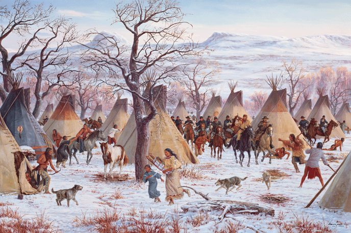
The 7th Cavalry attacking Black Kettle's camp on the Washita River
(From the exhibit at the Washita Battlefield NHS)
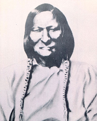
On November 26, 1868, the Peace Chief Black Kettle had just returned to his Washita River camp from a strenuous 100 mile mission through the snow to request permission to move his camp closer to Arapaho, Kiowa, and other Cheyenne tribes downriver. Permission was denied. His wife, Medicine Woman Later, uneasy with the rumors of U.S. troops in the area, wanted to move that night. She had good reason to feel uneasy. In 1864, at Sand Creek in Colorado, U.S. troops had attacked their peaceful camp, killed 125, and shot her nine times. She survived, but now at their winter camp, she had a premonition. The council of elders decided to wait until the next morning to move.


The Army was indeed nearby. The Osage and Lenape scouts had found tracks through the snow, possibly Black Kettle’s party returning to camp. The Army decided it led to a hostile encampment. That next morning, as dawn broke, Lt. Col. George Custer and some 700 soldiers of the 7th U.S. Cavalry stormed into the campsite and shot the Indians as they struggled out of their teepees. Warriors desperately fought to cover the retreat of the elderly, women, and children. Medicine Woman Later and Black Kettle hopped on a horse and then were killed as they crossed the Washita River.
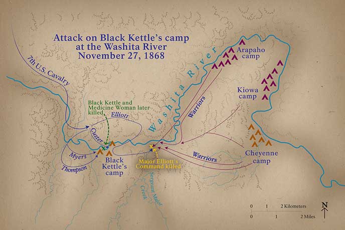
Map of Battle (From Washita Battlefield NHS web site)


Looking at the hills to the northwest over which Custer and his troops rode to attack the camp among the trees in the middle of the picture (Photo by Hunner)
At one point, Ben Clark, Custer’s Chief of Scouts, rushed in and told him that soldiers were killing women and children “without mercy.” Custer ordered his soldiers to stop shooting and instead take prisoners. The attack lasted only thirty minutes with estimates of forty to a hundred men, women, and children killed. Twenty-two soldiers lost their lives, seventeen of them from Major Joel Elliot’s attempt to chase down those trying to escape. He and his men ran into warriors from the Cheyenne and Arapaho camps downriver riding to the sound of battle. Custer had attacked the weakest camp, and now several thousand warriors started to surround the 7th Cavalry.
Some Cheyenne hid in the tall grass to escape the soldiers (Photo by Hunner)
The soldiers had orders to destroy the camp – burn the lodges and all the blankets, food, and supplies in them to deprive the Cheyenne of sustenance at the beginning of winter. Custer also ordered his troops to kill the Cheyenne horse herd so they sliced the throats and then when that proved too difficult, shot over 800 animals. Warriors from the other camps watched in horror from the nearby hills, afraid to attack since the soldiers had taken some fifty elders, women, and children captive.
Place where horses and mules were slaughtered (Photo by Hunner)
With ammunition running low and a growing force of enraged warriors nearby, Custer feinted a move to go downriver which sent the warriors retreating to protect their own camps. Relieved of a possible counterattack, the 7th Cavalry and their prisoners stole away into the fading light.

This is the second act in the tragedy of the southern plains Indian War. As Ranger Joel Shockley recounted, the first act happened at Sand Creek. When Col. Chivington and his soldiers attacked Black Kettle’s camp of peaceful Cheyenne and Arapaho in 1864 at Sand Creek, a Plains War erupted that lasted for years, culminating in the Battle at Little Big Horn (Joel’s third act). In response of the Sand Creek Massacre, warriors from the Cheyenne Dog Soldiers rampaged across the southern Plains to avenge their fallen comrades and family members. Peace treaties came and went, and Black Kettle signed some of them, but he had little control over the attacks by the warriors.

Francis Gibson, a lieutenant in the 7th Cavalry, later estimated that between August and November in 1868, 117 people were killed in the southern plains by the Dog Soldiers, with others scalped or captured, and almost 1,000 horses and mules stolen. As Western historian Paul Hutton said in the movie at the Washita visitors’ center: “The Army was humiliated. This was the Army that had defeated Robert E. Lee.” Something had to be done.

The Commander in charge of the Department of the Missouri, Major General Philip Sheridan, called for total war against the Indians. His aide-de-camp, Schuyler Crosby wrote: “The General’s policy is to attack and kill all Indians wherever met and to carry war into their own villages so that they will have to withdraw their marauding bands for the protection of their own families.”[1]
Lt. Col George Custer as he looked during the winter campaign at Washita (https://www.nps.gov/common/uploads/photogallery/imr/park/waba/)
Total war and winter campaigns were not new. Union troops scoured the Shenandoah Valley during the Civil War to remove the Confederates’ source of food. Kit Carson had conquered the Navajo in 1863 with a summer campaign of destroying crops and homes followed up with a winter attack. The massacre at Sand Creek also occurred as winter set in in November 1864. In regards to Washita, Paul Hutton concluded: “This was total warfare at its worst. With the dawn attack, they were the most vulnerable…. Total war against the Cheyenne was absolutely effective and forced them onto the reservation.” But he added that the Cheyenne “would have their revenge on Custer and the 7th Cavalry at Little Big Horn.”[2]

As I left the film about the massacre, I noticed that the other guy in the room had a t-shirt from Fort Pulaski. I struck up a conversation with Tim Sprano from Lynchburg, Virginia. He is a veteran park goer, having visited 371 of the 412 in the system over the last fifteen years. He teaches mathematics at Liberty University, but his other passion is our national parks. He remarked that every park has its own reason to exist, so take what it gives you. Here at Washita, he commented: “Obviously, we wouldn’t do stuff now that they did 100 years ago. We have different values today than of the past so it’s important to see and hear the whole story.”

After the movie, Park Rangers Joel Shockley and Richard Zahm spent over an hour chatting with me about what happened at Washita. Richard said this was an important site because people truly learn about our past here-- people who just stop by to stamp their NPS passports end up staying here all day. He said: “It’s so much more complicated than just cowboys and Indians…. I thought when I came out here, it would be a lot of black and white and it’s not. There are good guys and bad guys on all sides.”
NPS Ranger Richard Zahm (Photo by Hunner)
Joel agreed: “This is one of the best kept secrets in American history. It is far more complicated. This was like the Oklahoma City bombing for the tribes or like 9/11. There were not just Cheyenne here, there were a lot of Indians involved, and Mexicans too. Half of Custer’s command were immigrants from Ireland and Germany, a way to become citizens. All these cultures came together by happenstance…. This is part of your heritage, whether you have Indian in you, have soldier in you. It’s part of our heritage – all our warts and blemishes.”
After the Indians were forced onto reservations, many of their children were taken to boarding schools to further remove them from their tribe and culture (Photo from exhibit at Washita Battlefield NHS)
The Plains tribes lived on land that was a route to the gold and silver mines in Colorado. The Cheyenne, Arapaho, Kiowa, Comanche, and other tribes had roamed and fought over the Great Plains for thousands of years but then got in the way of Westward Expansion. As they protected their land, their families, and their cultures, they clashed first with the pioneers and miners moving in or through their homelands, and then with the U.S. Army. A Cheyenne Chief, Leg in Water, in 1864 said: “We loved the whites until we found out they lied to us and robbed us of what we had. We have raised the battle axe until death.”[3] After the Civil War, the Army used the tactics and weapons to wage total war to force Indians to move to reservations and kill those who refused to go. This last chapter of the Indian Wars in North America played out over the decade or so right after the Civil War. The legacy of conquest lives with us today, and as Richard, Joel, and Tim note, it is a complicated story viewed from our 21st century eyes.

Everywhere I have traveled in Driven by History, I have run into the deep heritage of our land, which starts with Native American peoples. They had rich and complex civilizations before Europeans arrived, they lost much of their ancestral lands and their culture, and they are still here.  

The Washita Battlefield became an Oklahoman state park in October 1966 and a National Historic Site on November 12, 1996.


[1] Mark Gardner, Washita Battlefield National Historic Site (Western National Parks Association: 2002), 8.
[2] “Destiny at Dawn,” documentary film shown at the Washita Battlefield NHS.
[3] From exhibit text at visitors’ center for the Washita Battlefield NHS.

Route 66 National Historic Trail from Illinois to California

Route 66 sculpture on Central Avenue in Albuquerque (Photo by Hunner)
At the end of July, I kicked off the East Coast leg of my Driven by History road trip driving on Route 66. I headed east from Albuquerque, New Mexico on Interstate 40 and hopped off at times to follow the two lane remnants of the Mother Road. It’s a story of multiple narratives, some faded, much like history in general. What’s left of Route 66 sometimes serves as a frontage road for the Interstate, and at other times, it winds through the countryside and small towns. To see the changes in our country since the 1950s, all you have to do is pull off the superhighway and drive the old route.

The United States has a long history of roads connecting our nation. In 1806, President Jefferson signed an act to create the National Road to connect the mid-Atlantic coast of Maryland and Washington D.C. with Illinois. Even during the late 19th century, as railroads spread across the continent and sped people and goods around, roads continued to serve vital routes for wagons, buggies, and bicycles. The safety bike came over from England and by the 1890s, 1,000,000 had been sold in the U.S. The suffragette Susan B. Anthony claimed “Bicycles did more to emancipate women than anything else.” The rage for bicycles also spawned a Good Roads movement.

At the turn of the 20th century, automobiles entered the scene. At first, cars served only the rich. Their price, their unreliability as they tended to break down, and the lack of good roads all made them more playthings than reliable transportation like horses or bicycles. Then in 1913, Henry Ford pioneered the automobile assembly line which radically reduced their cost. With the assembly line, a Ford car took only ninety-three minutes to make. Working people now could afford a Model T and for some, such a vehicle became essential for getting their produce to market or delivering goods to clients. Needless to say, cars revolutionized many aspects of 20th century living. We are all descendants of Ford, Dodge, and the other many automobile innovators.
Model T (From exhibit at National Route 66 Museum, Elk City, Ok.)
Cars required different roads than wagons. Steep hills and mountains, deep rivers, and muddy routes all impeded the horseless carriages. A demand for good roads grew as cars proliferated, and as adventurous souls began to drive across the country. As a result, a federal highway system began to unify the various routes and standardize the numbers for roads—odd numbered roads went north and south while even number ones went east and west.
Standard federal highway sign as the National Route 66 Museum in Elk City, Ok (Photo by Hunner)
One of the first of the unified federal road system, Route 66 came into being on November 11, 1926. It ran from Chicago, Illinois, through Missouri, Kansas, Oklahoma, Texas, New Mexico, Arizona and ended at Santa Monica, California. Its total length was 2,448 miles (3,940 km). From the beginning, Route 66 sought to connect small towns and villages to the rest of the country.

The Mother Road transported Great Depression refugees fleeing the Dust Bowl like the fictional Joad family in Steinbeck’s Grapes of Wrath and played a vital role in rushing people West during World War II as the government chose many places along the route for military facilities and war industries. It helped facilitate the greatest mobilization of workers and material in U.S. history as people flocked to Southern California for jobs. After the war, the road inspired both the TV show Route 66 which ran on CBS from 1960 to 1964 and Bobby Troup, Jr. who penned the hit song about getting your kicks on Route 66. Postwar popular culture embraced the Mother Road as an icon for the mobile American Dream.
Route 66 and Main Street (Photo in the National Route 66 Museum)
 Today, there is little historic fabric left of the Mother Road. Some segments still exist, and a few motor courts and buildings survive along the route. For those seeking Route 66, they must use their imagination and memories. Local efforts to preserve the route like the National Route 66 Museum in Elk City, Oklahoma, and the restored Conoco station in Shamrock, Texas are interesting parts of the great road. Car clubs and booster organizations work to preserve and publicize what is left to attract tourists. And it works. I heard of a group of Norwegians who flew into Chicago, rented Harley-Davidsons, drove the route, and then shipped the bikes back as they returned to Oslo. I also saw a Route 66 Diner on a highway in Sweden years ago. The Mother Road still attracts die-hard fans from around the world.

Restored Conoco gas station in Shamrock, Texas (Photo by Hunner)
The decline of Route 66 came about with the passage of the Federal Aid Highway Act of 1956. President Eisenhower experienced both the frustration of traveling cross country in pre-war U.S. as well as the ease of using Germany’s Autobahn highways. Using the German model, he helped pass this act to fund the building of limited access superhighways, partially justified as a way to get people out of big cities in case of a nuclear attack by the Soviets. By 1970, almost all segments of Route 66 were replaced by the interstate highways. The final patch of the Mother Road was bypassed by Interstate 40 at Williams, Arizona in October 1984.
Abandoned Esso Station on the Mother Road (Photo by Hunner)
As I drive to history, I see layers of the past side by side with the modern. Two lanes black-tops hugging the contour of the landscape next to broad ribbons of grey cement slicing through hills and leaping over valleys. I witness vehicles rocketing along at 80 and 90 miles an hour, and giant trucks pulling two, even three trailers charging down the highway. For the most part, interstates efficiently move vehicles, people, and goods across our vast country. I admit, when I have to make good time, I often jump on an interstate to make it to the next historic destination.

To be sure, interstates are engineering marvels. Overpasses soar through the air like ribbons of concrete. Interchanges weave cars and trucks at high speeds in an intricate dance to connecting routes. And people fly down the highways at breakneck velocities, far exceeding the speed limit and still arriving safely. It is a wondrous road system essential to the wellbeing of our county.

So here’s my concern. In the 1980s, I drove trucks full of art around the country. Back then, I enjoyed country cafes, often on main streets in the small communities. Today, I vainly search for small locally owned restaurants in these small towns. To find a meal or even a cup of coffee, one must often go out to the interstate exits and have a franchised meal.  The blur of speeding along at 75 miles per hour, the homogenization of the franchises on interstate highway system dull us to the rich diversity of our country.
Traffic jam at rush hour in Indianapolis on I-470 bypass (Photo by Hunner)
William Least Heat Moon published Blue Highways in the 1982 about his road trip on the country byways off of the interstates. He is an elegiac writer with a great eye for the life in people and landscapes. He advocated for slowing down and enjoying the trip as opposed to rushing to our destinations. In Blue Highways, he taps into who we are as a country as he interacts with the people of America. It serves as a counter-narrative to our fast paced lives and perhaps evokes what Route 66 fans seek when they travel the Mother Road.
Classic gas pumps at the Conoco station in Shamrock, Texas (Photo by Hunner)
In a land as big as ours, we need roads to connect us. Thomas Jefferson knew as much when he signed a law creating a National Road. Dwight Eisenhower also knew this when he advocated for the interstate highway system. But roads don’t just get us to where we are going. They take us through the vast cornfields of the Midwest and wheat fields of the Great Plains, through the hot deserts of the Southwest, through the dense cities of the Atlantic seaboard, and through the thick forests of the South. Underneath our modern highways lay two lane roads, under those lay pioneer tracks, and under those lay Native American trails. Our transportation network is built upon more ancient routes and shows us that humans embrace mobility, that from our first steps on this continent we immigrated, we traveled for trade and for adventure, and we pursued a dream of finding a better place for ourselves and our families.
The Mother Road in Missouri with Interstate 40 in the background (Photo by Hunner)
My next blog which I also post tonight is a short detour off of Route 66. I visited the Washita Battlefield National Historic Site in western Oklahoma. We see Cheyenne Peace Chief Black Kettle again as well as George Custer.

The Wagon Wheel Motor Court in Missouri on Route 66 (Photo by Hunner)

Monday, August 1, 2016

Yosemite National Park at Yosemite, California

The valley floor at Yosemite with El Capitan to the right, Half Dome center in the distance, and Bridal Falls to the right. (Photo by Hunner)
The spectacular landscape of Yosemite’s bald domes and deep valleys, of its crashing waterfalls and rarefied high country vistas took over 100 million years to create. The dramatic cliffs are made of granite, formed deep in the earth as molten rock which slowly cooled and solidified into massive stone megaliths. About sixty-five million years ago, the granite core of the Sierras Nevada mountains became exposed. Twenty-five million years ago, tectonic forces lifted and tilted the granite range and formed the tall Sierra Nevadas. Then the forces of water and ice began to shape the hard stone.

Enter the glaciers. Over the last two to three million years, ice fields and glaciers at times capped the high peaks and during ice ages, descended down the valleys to scour and change the landscape. Rivers had cut “v” shaped valleys, but the grinding of glaciers created “u” shaped ones with wide level floors filled with glacial sediment. Geologic time is writ large in the Yosemite Valley.

Human have also left their marks on the Yosemite landscape. The Ahwahneechee tribe of the Miwok Indians have lived in the Southern Sierras for perhaps 7,000 years. Moving from the deep canyons to high alpine meadows, the Ahwahneechee developed a hunter and gatherer life style suited for the high Sierras. Change came in the early 19th century with contact with Europeans-Americans. After the Gold Rush brought a flood of miners to the region, John Savage set up a camp in the foothills which was attacked by the tribe. In retaliation, a volunteer militia called the Mariposa Battalion fought and eventually defeated the Ahwahneechee. A lake in the high country where a major battle occurred was named after Ahwahneechee’s Chief Tenaya. Tenaya and his tribe were forcibly removed to a reservation near Fresno, but Congress did not accept any of the eighteen treaties made with Californian Indians in 1851 and 1852. Over the years, even though the U.S. government forcibly evicted the Ahwahneechee from the Yosemite Valley, tribal members still live in the area.

Some argue that Yosemite is our oldest park. Here’s why—President Lincoln, in 1864 in the midst of the Civil War, signed the Yosemite Land Grant, setting aside the Yosemite Valley as a nature reserve run by California. To be sure, Yellowstone became our first National Park in 1872, but Yosemite was our first protected place. Lincoln never visited Yosemite, but his legacy in protecting it place continues to thrill millions of people a year. Four years after Lincoln designated Yosemite as a nature reserve, John Muir arrived in the valley.

Already a world traveler, Muir fell in love with Yosemite—with its high mountains, the Granite Cliffs, the sequoia trees at Mariposa Grove, and the valley floor. In an essay for The Century magazine in 1890, he marveled about the beauties of Yosemite.
The high Sierras on Tioga Road (Photo by Hunner)

About the High Sierra, he wrote: “It seemed to me the Sierra should be called, not the Nevada or Snowy Range, but the Range of Light. And after ten years in the midst of it, rejoicing and wondering, seeing the glorious floods of light that fill it,-- the sunbursts of morning among the mountain peaks, the broad noonday radiance on the crystal rocks, the flush of the alpenglow, and the thousand dashing waterfalls with their marvelous abundance of irised spray,-- it still seems to me a range of light.”[1]
The brow of El Capitan (Photo by Hunner)
Concerning the Granite Cliffs, Muir exults: “The brow of El Capitan was decked with long streamers of snow-like hair, Cloud’s Rest was enveloped in drifting gossamer films, and the Half Dome loomed up in the garish light like some majestic living creature clad in the same gauzy, wind woven drapery, upward currents meeting overhead sometimes making it smoke like a volcano.”[2]
Sequoias at King's Canyon (Photo by Hunner)
Muir glories in the big trees: “The majestic sequoia, too is here, the king of conifers, ‘the noblest of a noble race.’ All these colossal trees are as wonderful in the fineness of their beauty and proportions as in stature, growing together…. Here indeed is the tree-lover’s paradise, the woods, dry and wholesome, letting in the light in shimmering masses half sunshine, half shade, the air indescribably spicy and exhilarating, plushy fir boughs for beds, and cascades to sing us asleep as we gaze through the trees to the stars.”[3]
Yosemite Valley with Half Dome in the background (Photo by Hunner) 
About the Yosemite Valley, he proclaims: “No temple made with hands can compare with the Yosemite. Every rock in its walls seems to glow with life. Some lean back in majestic repose; others, absolutely sheer or nearly so for thousands of feet, advance beyond their companions in thoughtful attitudes…. How softly these mountains are adorned… their feet set in groves and gay emerald meadows, their brows in the thin blue sky, a thousand flowers leaning confidingly against adamantine bosses, bathed in floods of booming water, floods of light while snow, clouds, winds, avalanches, shine and sing and wreathe about them as the years go by!”[4]

Rallying around such words, advocates for Yosemite found allies in Congress, and Yosemite became a National Park in 1892. But the battle was not totally won. To continue to protect the sacred places in the Sierras, in 1901 Muir published Our National Parks, and in 1903, President Teddy Roosevelt visited Yosemite. Muir kidnapped him for several days of camping out in the high country, to the chagrin of the gathered politicos who wanted to bend the president’s ear. Together, Roosevelt and Muir, under the stars around a campfire and hiking over the granite domes, laid the foundation for a conservation policy that protected some natural resources and preserved the shrinking wilderness.
President Teddy Roosevelt and John Muir at Glacier Point in 1903 (Photo from NPS)
The last chapter in Muir’s life ends in a preservation tragedy. At the north end of the Yosemite National Park lays the Hetch Hetchy Valley fed by the Tuolumne River.  The growing city of San Francisco coveted the water in that valley and after the Great Earthquake of 1906, argued and won the rights in 1913 to that liquid resource. With the rights, the city dammed the Hetch Hetchy and siphoned the water off to the Bay Area. Muir and the Sierra Club fought hard against this, and he died a year later, some say a broken man from the loss of this stunning part of a national park.

When I visited Yosemite, the Mariposa Grove of giant sequoias was closed to the public for rehabilitation. There are almost 500 of these largest living things on earth in the grove, which was included in the original grant created by Lincoln in 1864. J. Smeaton Chase, an Englishman, wrote this about Mariposa Grove: “As one stands in the dreamlike silence of these groves of ancient trees, the solemnity of their enormous age and size combine to produce a cathedral mood of quietude and receptiveness.”[5]

Since I couldn’t get to the sequoias in Yosemite, I went south to King’s Canyon to experience these Big Trees. Granted, redwoods are taller, but sequoias’ trunks are bigger, and those massive trunks retain their girth as the trees climb. In terms of actual living mass, sequoias have more wood than redwoods.
The General Grant Sequoia at King's Canyon (Photo by Hunner)
I arrived at the General Grant tree after a brisk walk from the nearby campground, late for a Ranger Amber’s talk. This is the second biggest tree in the world, with the General Sherman tree at Sequoia NP taking the honors. Between 1,600 and 1,800 years old, the General Grant sequoia takes twenty people holding hands to encircle its trunk and in a weird statistic, could hold more than 37,000,000 ping pong balls. Here’s some more stats on the General Grant: height = 268 feet (82 meters); circumference = 107 feet (33 meters); diameter = 40 feet (12 meters); and weight = 1,254 tons (1,325 metric tons). 
The trunk of a sequoia at King's Canyon. Notice the people on the left. (Photo by Hunner)
A saving grace for all sequoias is that they burst into splinters when felled so they are unsuitable for lumber planks. Shingles, yes and also fence posts, but considering it takes so much effort to cut one down, the resultant wood is not worth the trouble.

At the end of her presentation, I talked with some rangers about my concerns concerning all the dead trees on the western slopes of the Sierras. I had read in a Los Angeles Times  story that Sunday that the U.S. Forest Service estimated the 20,000,000 trees in the Sierra Nevadas had died since October and 60,000,000 since 2010.[6] I asked if wild fires could sweep through the groves here, at Sequoia National Park, and at Yosemite, and destroy these majestic ancient beings. One of the rangers said: “Perhaps we are the last generation to see these monarchs of trees.” Shocked, I spent the rest of the afternoon wandering around this cathedral of giants.
A trunk of a massive sequoia at King's Canyon (Photo by Hunner)
Yosemite, Kings Canyon, and Sequoia National Parks are places of immense beauty and spirit. Granite megaliths, ancient trees, deep valleys, high alpine mountains, tall waterfalls, they establish the sacredness of wilderness and allow us to commune with natural wonder. They change, as Muir wrote, our perception of nature and the world around us. Without such parks and without the people who struggled and continue to work to preserve these places, we would be a lesser nation and people. Just ask the over 4,000,000 people who visited Yosemite in 2015 or the 300,000,000 who went to some unit in our NPS system last year. The parks transcend our differences and unites us around their natural and historical landscapes.
The Upper and Lower Yosemite Falls, the tallest waterfall in the U.S. (Photo by Hunner)
Yosemite became a National Park on October 1, 1890 and was designated a World Heritage Site on Oct. 31, 1984. King’s Canyon was established as General Grant NP on Oct. 1, 1890 and was renamed and enlarged in 1940. Sequoia NP was created on Sept. 25, 1890


[1] John Muir, The Treasures of the Yosemite, (Lane Magazine and Book Company: Menlo Park, 1970), 16.
[2] Ibid, 48.
[3] Ibid, 20.
[4] Ibid, 18-19.
[5]Ardeth Huntington, YosemiteNational Park: A Personal Discovery (Mariposa, California: Sierra Press, n.d.), 41.
[6] Los Angeles Times, June 23, 2016, A-1.

Monday, July 25, 2016

Redwoods National and State Parks, Crescent City, California and Muir Woods, National Monument, Mill Valley, California

Let’s be frank. Words and photos cannot adequately capture some of the wondrous parks in our land. Redwoods NP and Muir Woods NM fall into this category. These are several of the Crown Jewels of the NPS. To truly cover these two NPS site and the other natural wonders of the California, we also need to look at John Muir, the grand spirit of the High Sierras. First, these majestic parks, the redwoods, then Muir.
Tall trees at Redwoods NP (Photo by Hunner)
At Redwoods National and State Parks on the Pacific coast in northern California, the tallest living things in the world grow. They reach upwards of 370 feet, and their trunks are fifteen feet in diameter. Some redwoods are as tall as the Statue of Liberty and taller than a thirty story building.  Standing at a base of a redwood with hands on the grooved bark and looking up, I marveled at the size and age of such trees. Most groves hold trees 500 to 700 years old with some older than 2,000 years. These ancient beings are not only the tallest living things on the planet, but some of the oldest.

Redwoods thrive along the coastal mountains of northern California. Fog in the summer brings nourishing moisture, and the lack of winter frost ensures a year round growing season. Their bark is fire resistant and repels harmful bugs. At the Redwoods Parks, I spent hours hiking along the Brown Creek, Rhododendron, and South Fork Trails. As I first wandered and gazed up at these ancient groves, I kept stumbling on the exposed roots. One ranger told me that the root system is their only weakness. Since these tall trees have no tap root and are shallow, not much deeper than eight to ten feet, they are prone to winds which can knock them over. The roots do spread out up to 100 feet, and cover the grove’s floor. I made slow progress as I looked up at the giants and glanced down at their roots. In truth, I stumbled a lot under the red and green canopy of the forest.
A downed redwood with exposed shallow root system (Photo by Hunner)
The Redwoods Parks is a joint venture between the NPS and California State Parks. For forty miles of coastline along the Pacific, the state and national parks preserve these wondrous trees. Preservation started over 100 years ago as alarms grew about the decimation of the redwood groves by logging.
In 1918, the Save-the-Redwoods League formed and began buying up threatened groves that are now Jedediah Smith, Del Norte Coast, and Prairie Creek Redwoods State Parks. While the State Parks protected these tall trees, more old growth forests fell. A survey by the National Geographic Society in the 1960s revealed that of the “original 2 million acres of virgin redwoods, only 300,000 acres, or 15 percent, remained uncut, with 50,000 of those acres in state parks.”[1] This report galvanized many to seek further protection. The Sierra Club proposed a 90,000 acre park while those in the lumber industry countered with claiming that just the three existing state parks should become the national one. Congress compromised and established the 58,000 acre Redwood NP in 1968 to compliment the state parks.

Who worked to protect the redwoods? Of course, many people called for their preservation, perhaps none so influential as John Muir. Born in Dunbar, Scotland in 1838, he came with his family to Wisconsin in 1849. He studied botany, chemistry, and geology for several years at the University of Wisconsin-Madison until he left to attend what he called “the University of the Wilderness.” In the late 1860s, he suffered an eye injury at a factory that temporarily blinded him. Once recovered, he walked 1,000 miles to Florida. Eventually, he arrived in San Francisco by boat in 1868 and wandered around the Golden State.
John Muir (from www.pbs.com)
When he got to Sierra Nevadas, he settled in the Yosemite Valley where he built humble shacks, worked at a saw mill, and herded sheep. And he fell into a deep love with the mountains, valleys, and meadows of the Sierra Nevadas.  About the high country, Muir wrote: “Everybody needs beauty as well as bread, places to play in and pray in, where Nature may heal and cheer and give strength to body and soul.” Reveling in the spirituality that surrounded him in the mountains, Muir started writing to proclaim the benefits of going into the wilderness. 

To the revered writer Ralph Waldo Emerson, Muir invited him to join him: "Do not thus drift away with the mob, while the spirits of these rocks and waters hail after you, after long waiting as their kinsman and persuade you to closer communion.... I invite you to join me in a month's worship with Nature in the high temples of the great Sierra Crown beyond our holy Yosemite." His writings attracted Emerson and others to join and support the preservation of these holy places. 

Muir did not see Nature as a warehouse of natural resources, but as a storehouse of spiritual sources, and he actively sought to protect these temples of God. His main tool was his pen. He wrote about Nature for many different publications and helped get Congress to protect Yosemite in 1890. In 1892, along with a number of supporters, Muir founded the Sierra Club. He wanted to "do something for wildness and make the mountains glad." He was its president until his death in 1914, and the Sierra Club continues to be a strong voice for preservation.

His advocacy for nature, his cries for the protection of tall trees, alpine meadows, thundering waterfalls, mirror lakes, deep valleys, and high domes helped create the preservation movement that led to the establishment of the National Park Service in 1916. We will come back to him in the next week’s posting about Yosemite. Let’s return to the glorious redwoods.
Tall trees (Photo by Hunner)
Muir Woods, in the hills north of the Golden Gate Bridge, also honors the redwoods.  A postage stamp sized park at 553 acres, its attraction is up, not on the ground. Two paved paths snake up the narrow valley on each side of the small Redwood Creek. Many people were at Muir Woods the day I was there, but they mainly walked on the main trails along the creek bed. I jumped off the Redwood Creek Trail and quickly left the crowds as I hiked up the Canopy View Trail. Ambling along, breathing in the rich oxygen given off by these consumers of carbon dioxide, I breathed in the scents of trees hundreds, even thousands of years old and communed with these ancient beings. Talking about the groves at Muir Woods, a friend once said: “Nature is so generous. It is eternity.” This is a magical place.

At a table near the visitors’ center, I met two summer employees -- Danielle Shinmoto and Brandon Burkes. These college students explained the acquisition of the park. In 1905, William and Elizabeth Thacher Kent paid $45,000 for this valley to save some of the last uncut stands of redwoods near San Francisco. After the 1906 earthquake, the North Coast Water Company tried to gain access to the redwoods for the wood to help rebuild San Francisco, but the Kents thwarted this by donating 295 acres to the federal government. In 1908, President Theodore Roosevelt proclaimed their property a National Monument. The Kents insisted that the monument be named to honor John Muir’s conservation efforts.
Muir and William Kent
(From Wikipedia Commons)
Elizabeth Thacher Kent
(From wikipedia Commons)


How could the president set aside public lands? The recently signed Antiquities Act gave Teddy that power, and presidents to this day invoke this act to preserve unique pieces of our land and heritage. Roosevelt was a new type of politician, a “progressive” who reshaped our government.  

Through the 19th century, laissez-faire capitalism ruled, and natural resources were used without much thought about the future. After the turn of the 20th century, a new ethos emerged that centered around the policy of what would bring "the greatest good for the greatest number of people over the greatest period of time." This long view utilitarian approach to Nature transformed the previous hands-off, no regulation attitude. Throughout the 20th century, the utilitarian policy has ruled so that we now scientifically manage the resources on our public lands.

The history of the NPS reflects the web and flow of the struggle between the policies of laissez-faire versus the management of our natural resources on public lands. William Kent, being a Progressive member of the U.S. House of Representatives, supported the protection of our natural resources and introduced and helped pass the Organic Act of 1916 which created the National Park Service.

Without John Muir, Teddy Roosevelt, Elizabeth and William Kent, and thousands of others, we might not have Muir Woods and Redwoods National Parks, we might not have Manzanar NHP and Independence Hall NHP, we might not even have the National Park Service. The deep yearning and dedication of many people to preserve our natural and historic sites have enriched our country. 

Without these people and these treasured places, we would be a lesser country.

Redwoods National Park was established by Congress and President Lyndon Johnson on Oct. 2, 1968. It now has 105,516 acres. In 1980, it was designated as a World Heritage Site. Muir Woods was proclaimed a National Monument on January 9, 1908 by President Teddy Roosevelt in the last months of his presidency. It now holds 553 acres. 
Redwoods and Rhododendrons at Redwoods NP (Photo by Hunner)


[1] Richard Rasp, Redwood: The Story Behind the Scenery(KC Publications, 1989),46-47.

Monday, July 18, 2016

Itinerary for East Coast and American South Road Trip through our National Parks

Here is the updated itinerary (As of October 9) for the Driven by History road trip.

As with the West Coast trip, this will probably change. As Paul Theroux says in Deep South, his latest book --  that’s the joy about road trips in this country—we can go where fancy takes us.

Week of July 31
Leave Las Cruces, New Mexico and drive on Route 66 National Historic Trail (NHT) from New Mexico towards Illinois
Washita Battlefield National Historic Site (NHS), Oklahoma
Oklahoma City National Memorial (NM), Oklahoma
Trail of Tears NHT, Oklahoma
Jefferson National Expansion Memorial at St. Louis, Missouri
Conner Prairie Interactive History Park, Indiana

Week of Aug 7
Dayton Aviation Heritage National Historical Park (NHP), Ohio
Hopewell Culture NHP, Ohio
Fort Necessity National Battlefield (NB) and Flight 93 NM, Pennsylvania
Women’s Rights NHP, New York

Week of Aug 14
Erie Canal, New York
Fort Stanwix NM, New York
Saratoga NHP, New York
Fort Ticonderoga, New York
Boston area—Lowell NHP, Adams NHP, Minute Men NHP, Salem Maritime NHS, Old Sturbridge
          Village, and Boston NHP, Massachusetts

Week of Aug 21
Plimouth Planation, Massachusetts
New Bedford Whaling NHP, Massachusetts
Mystic Seaport, Connecticut 
Statue of Liberty and Ellis Island NM and September 11 Memorial, New York and New Jersey
Morristown NHP, New Jersey

Week of Aug 28
Valley Forge NHP, Pennsylvania
Gettysburg National Military Park (NMP), Pennsylvania
Antietam National Battlefield (NB), Maryland

Week of Sept 4
Harper’s Ferry NHP, West Virginia
Chesapeake and Ohio Canal NHP, Maryland, West Virginia, and Washington D.C.
Monacacy NB, Maryland
Ford's Theater NHS, National Mall, and Frederick Douglass NHS, Washington D. C
Appomattox Court House NHP, Virginia

Week of Sept 11
Attend the Bridging Ages conference in Kalmar Sweden

Week of Sept 18
Copenhagen historic sites and visit Bornholm, Denmark

Week of Sept 25
Return from Denmark
Wilderness and Chancellorsville NMP, Virginia
Petersburg NB, Virginia
Colonial Williamsburg, Virginia

Week of Oct 2
Fort Sumter NHS and Fort Moultrie, South Carolina
King's Mountain NHP, South Carolina/North Carolina
Andrew Johnson NHS, Tennessee

Week of Oct. 10
Great Smoky Mountains NP, Tennessee
Manhattan Project NHP at Oak Ridge, Tennessee
Tennessee Valley Authority, Tennessee
Chickamauga and Chattanooga National Military Parks, Tennessee
Kennesaw Mountain National Battlefield Park, Georgia

Week of Oct 17
Andersonville NHS, Georgia
Tuskegee Airmen NHS, Alabama
Selma to Montgomery Civil Rights Trail, Alabama

Week of Oct 24
Natchez Trace National Scenic Trail and Parkway, Alabama and Mississippi
Vicksburg NMP, Mississippi
New Orleans Jazz NHP, Louisiana
I will present a lecture about Driving by History at University of Louisiana at Lafayette on Oct. 27 

Week of Oct 30
San Jacinto State Historic Park, Texas
Palo Alto Battlefield NHP, Texas
San Antonio Missions NHP, Texas
Fort Davis NHS, Texas
Return to Las Cruces, New Mexico


Manzanar National Historic Site, Independence, California


At 9 am in mid-June, the sun already blasted the valley in eastern California. I walked through the 90 degree heat to the visitors’ center as dust devils swirled across the desert. A Park ranger raised the flag as I went by, inviting me to go into one of the NPS’s sites of conscience. This harsh land reflects the harsh deeds done in time of a national emergency.
Japanese Americans arriving in Manzanar 1942 (From Visitor's Center exhibit)
Right after the Japanese attack on Pearl Harbor, some Japanese-American families at Long Beach, California received visits from the FBI. For teenager Mike Miyagashima, his father did not return from his fishing boat on December 7.[1] Mike did not see his father for 18 months. To legalize the detention without due legal process of American citizens, President Roosevelt signed Executive Order 9066 on February 19, 1942. Eventually, over 100,000 people of Japanese descent were imprisoned in camps like Manzanar and in Minidoka NHS (which I wrote about on June 3rd). In short, Japanese-American citizens (Nisei) and Japanese immigrants (Issei) along the West Coast were rounded up in the spring of 1942 and incarcerated at “internment” camps. Surrounded by barbed wire and watch towers and patrolled by armed guards, these camps detained citizens and immigrants of Japanese ancestry because they looked like the enemy and their loyalty to the U.S. was doubted.
Anti-Japanese sentiment (Photo from exhibit at Visitors' Center) 
Manzanar was one of ten official War Relocation Authority (WRA) camps used to carry out this detention mandated by Executive Order 9066. The Order eliminated the constitutional protections of due process for citizens and violated the Bill of Rights. Two-thirds of the 120,000 persons of Japanese descent incarcerated in American concentration camps were American citizens, an act that reflected decades of anti-Japanese discrimination and then war time propaganda.
Map of the 10 WRA camps (Map from exhibit)
The stories of the spirit of the incarcerated Japanese-Americans has filled volumes. Imprisoned without court trials with their families torn apart, these mainly citizens lost their land and businesses as they had to quickly liquidate their estates  before and rushing to the train station with only two suitcases. Some Californian fortunes today arose from the bargain priced acquisitions of productive farms and prosperous businesses.


In the movie “Remembering Manzanar” shown at the Visitors’ Center, one Japanese-American said: “It was just a devastating day for all of us. I will never forget. Because I looked like the enemy, I was treated like one.” Another internee speculated that “It must have been difficult for teachers to talk about democracy.”
Japanese American escorted to train for removal to camps
(From exhibit)
Forlorn boys on way to camps
(From exhibit)


Despite the wrenching apart of families who then arrived at camps not yet completed, the internees created mini-cities with many amenities of a normal town. Active farms, retail shops, sports leagues, schools, and recreation halls filled the uncertainties of enforced detention. At both Minidoka and Manzanar, perhaps unbeknownst to each other, the internees created vibrant communities and responded to their prisons in various ways.

Some young men joined the U.S. Army. Six thousand Nisei served in the Military Intelligence Service translating Japanese communications. More than 10,000 more Nisei served in the 100th Infantry Battalion and the 442nd Regimental Combat Team of the Army which fought in some of the fiercest action in Europe as they slogged up the Italian mountains in 1944. The Japanese Americans in the  442nd received more combat awards than any other unit of its size in the Army. In praise of the men who fought in the 442nd, General George C. Marshall said: “They were superb!.... They took terrific casualties. They showed rare courage and tremendous fighting spirit. Not too much can be said of the performance of those battalions in Europe and everybody wanted them….”[2] Not enough can be said about these Japanese-Americans who fought for a country which had imprisoned them and their families.
Japanese Americans fighting in the 442nd Regimental Combat Team in France late 1944.
(Photo from https://upload.wikimedia.org/wikipedia/commons/6/6e/442_regimental_combat_team.jpg
Back at the homefront, Manzanar residents made the best of a bad situation. Four thousand people worked at the camp as clerks, chemists, nurses, doctors, accountants, teachers, fire fighter, switchboard operators, and camouflage net makers. At a building in the camp, five hundred people turned out thousands of camouflage nets a month to support the war effort.

Love also flourished as 188 couples married at Manzanar, and 541 babies were born there. For this small city, the 250 bed hospital was the largest one between Los Angeles and Reno. And like at Minidoka, people played the all American sport of baseball.
Playing baseball at Manzanar (From exhibit)
As usual, I arrived at Manzanar without an appointment. I asked to talk with the Chief Interpreter and heard that she was busy. I went through the excellent exhibit and watched the film at the visitors’ center and then asked again. A few minutes later, I met Alisa Lynch, who had broken off what she was doing to spend an hour with me. I’m richer for her time.

Alisa has been at Manzanr NHS for fourteen years, even before it officially opened. She spoke from her heart about the history as well as the continuing relationship that the place has with the people incarcerated here and their descendants. She told me that the site is “conserving history of people who don’t consider themselves part of history.” She talked about all the stories of the people who were here: “This is reminder that history is about real people. I carry 10,000 lives, 10,000 stories. We don’t think of government policies in terms of real people but you can walk here where they walked. We can’t totally recreate 10,000 people in 800 buildings, but history is always relevant.”

Alisa was especially proud of the exhibit on the No-No issue. The WRA had all the internees fill out a loyalty questionnaire. Question 27 asked if they would serve in the U.S. military, while question 28 asked if they would foreswear their allegiance to the Japanese emperor Hirohito. As Alisa noted, that’s like asking “how many of you have stopped beating your pet?” Many of the internees had no allegiance to Hirohito so could not foreswear something they never had. Others did not want to serve in the military of a country that violated their civil rights. So, those who answered “no” to both questions were called No-No Boys. Considered disloyal by the WRA, they were sent to the detention center at Tule Lake. At its height, Tule Lake held 18,000 internees guarded by  1,200 Military Police. Some No-Nos were deported to Japan during the war.  The staff and consultants at Manzanar used diaries, oral histories, and donated artifacts from incarcerated families to mount this exhibit on the No-Nos. To recognize the excellent research, interpretation, and installation of this exhibit, the Organization of American Historians in 2016 awarded Manzanar NHS and Park Rangers Patricia Biggs and Rose Masters the Stanton-Horton Award.
The award winning exhibit about the Loyalty Questionnaire (Photo by Hunner)
Manzanar closed on November 21, 1945. When they left, those incarcerated were given $20 and a bus ticket back to their home city. Because these internees had sold their houses,  businesses, farms in haste, many had no place to return to, and they spent decades rebuilding their lives. Today, an annual pilgrimage attended by up to 1,000 people keeps alive the memories of Manzanar.

In 1988, Congress passed the Civil Liberties Act which paid former detainees $20,000. In signing the bill, President Ronald Reagan admitted that it was mistake to intern Japanese-Americans. He said: “When we violate that Constitution, we begin to unravel as a nation.” President George H.W. Bush’s apology letter sent to over 82,000 people contained the following: “A monetary sum and words alone cannot restore lost years or erase painful memories; neither can they fully convey our Nation’s resolve to rectify injustice and to uphold the rights of individuals…. But we can take a clear stand for Justice and recognize that serious injustices were done to Japanese Americans during World War II.”[3] The U.S. government has paid over $1,200,000,000 to the former detainees.

Manzanar’s auditorium (today’s visitors’ center) was built by camp residents. It held 1,280 seats and after the war, served as the Inyo County road maintenance shop for forty years. The NPS bought it from the county in 1996, and after a $3,500,000 renovation, the Manzanar NHS opened on April 24, 2004. Almost 100,000 people visited Manzanar last year.

As I left Manzanar and drove through the dry Owens Lake valley on my way to Death Valley, large dust devils buffeted my rig. This is a harsh land.

The Cemetery at Manzanr (Photo by Hunner)


[1] Interview with Mike Miyagashima by Jon Hunner at Las Cruces, NM.
[2] Accessed at the “the422.org” website, July 18, 2016.
[3] Letter from President George H.W. Bush reprinted in Park brochure.