On the plateau above Chaco Canyon rests the multi-room ruins of Pueblo Alto. The human made trail up the cleft in the canyon’s cliff and along the plateau dates back a thousand years. During the summer monsoon season with its afternoon thunderstorms, a person climbing up out of the canyon and hiking to Pueblo Alto sometimes dodges downpours and sees nearby lightning strikes. Standing in the ruins of Pueblo Alto, buffeted by wind, I saw a broad road sweeping north toward the Salmon and Aztec ruins some thirty miles away. In fact, Pueblo Alto is one of the gateways into Chaco Canyon, the end of a massive network of roads which funneled peoples and goods to this desert center from around North and Central America.
 |
| Artist's Recreation of Pueblo Bonito in 12th Century (NPS) |
Set at 5,000 feet above sea level amidst a parched landscape which gets less than ten inches of annual rainfall, the Four Corners region of the Southwest holds a sparse beauty of earthy tones, hardy plants, and wide open spaces. Mountain ranges fifty miles away frame the horizons, and mesas punctuate the foreground like desert islands. Chaco Canyon cuts through the landscape with its mile wide trough which runs east to west for twenty miles. Scattered along the canyon floor and interspersed on the plateau tops are over a dozen major ruins and numerous smaller ones, all illustrating the many skills of the Chaco builders.
The Chacoans created a sophisticated civilization between 900 and 1200 Current Era (CE). They grew corn which like elsewhere transformed their ancestors from hunters and gatherers to farmers. To this day, Native Americans in New Mexico talk about the three sisters of food—corn, squash, and beans. Perhaps the most important of these sisters is corn, sometimes called the Corn Mother. Other foods, unknown to the rest of the world, also developed in the Americas. Squash, beans, chiles, manioc, potatoes, chocolate, and tobacco are some of the unique crops that provided healthy nutrition. In fact, these foods provided Americans a better diet than the Europeans had at the time. Once these crops crossed over to Europe, they continued to revolutionize people’s lives with better nutrition and even prevented starvation. We will explore this “Columbian Exchange” more in a later posting.
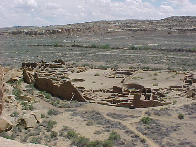
As the largest complex in the Chaco valley, Pueblo Bonito had 650 rooms spread out over two acres in a D shaped structure. The long edge of the D faces south for solar gain but also for the important orientation along the cardinal points treasured by the Chacoans. Pueblo Bonito, with its earliest construction begun in the 10th century, rose five stories. Until the 20th century, Pueblo Bonito was the largest built structure in the United States.
 |
| Pueblo Bonito (Photo by J. Hunner) |
 |
| Room at Pueblo Bonito with vigas (Photo by J. Hunner) |
It grew over three centuries in a way that entailed planning on a complicated and massive scale. Take for instance the wood roof beams (or vigas). Excavations of the earliest vigas show that they came from nearby piñon trees. The Chacoans quickly deforested the piñon trees so they had to go to the nearby mountain ranges for their timber. At the Chuska Mountains some fifty miles west, work crews felled large Ponderosa Pine trees with stone axes. While still green and soft, Chacoans chopped them up into the right size for the various rooms. The vigas then dried for two years to make them lighter to carry. Men then carried these logs fifty miles and built the rooms of the great pueblos and kivas at Pueblo Bonito. Archeologists estimate that 215,000 vigas were used in building the Great Houses and the other structures in Chaco Canyon.
In the middle of the pueblos’ plazas and interspersed among their numerous rooms are often circular kivas where clans gathered to worship, socialize, teach, and work. At Pueblo Bonito, thirty-five kivas grace the ruin. These numerous places show that the Chacoans were likely a deeply religious people.
 |
| Kiva at Pueblo Bonito (Photo by J. Hunner) |
For decades, archeologists have wondered why humans established a dense urban complex in a harsh desert setting. Some have speculated that the canyon served as a distribution center to share the harvest around the Chacoan region to communities whose crops had failed. Others proposed that it was a seasonal ceremonial center, visited by a large number of peoples from the outlying communities spread around the region. A peculiar fact uncovered by the archeologists is that there are relatively few burials at Chaco Canyon. They concluded that the large pueblos with hundreds of rooms housed only a couple of thousand people, whose population swelled during the seasonal periods of ritual and festivals.
Here’s where it gets pretty interesting. Rising up out of the east end of the canyon lies Fajada Butte, a tall lone mesa where Anna Sofer found a spiral petroglyph she calls the Sun Dagger half way up the mesa. This spiral, carved into a rock hidden behind three large slabs, is a time keeper. A dagger of sunlight bisects the shadowed spiral on the summer solstice. At the equinoxes, a dagger of light frames the spiral. On the solstices and equinoxes, signal fires spread the news to the whole Four Corners region. Using their built environment as time pieces, the Chacoans had a precise seasonal calendar.
 |
| Slab casting sunrise shadow on spiral with inset of Sun Dagger (Photo from www.solsticeproject.org/lunarmark.htm) |
Some Chaco buildings perform an even more amazing feat: they track the 18.2 year progression of where the moon rises in the east. At the pueblo of Chetro Ketl on the canyon floor, one of the walls runs along a straight line for about 300 feet. This alignment points to the spot on a nearby cliff where the moon rises on the farthest northern point of its 18.2 year cycle. Few if any other buildings in the world orient so precisely to this subtle lunar cycle.
 |
| Prehistoric Stairways climbing out of the Canyon |
Roads radiate out from the canyon as straight avenues. Ancient stairs carved into the cliff faces funneled people into and out of the canyon where they then used eighteen feet wide roads lined with stone curbs to travel to the over 150 other Great Houses and beyond. Sea shells from the Pacific Ocean, soapstone from the Midwest, and amazingly, parrot feathers from the tropics of Central America have surfaced in the excavations at Chaco. For example, in 1941, park personnel, wanting to stabilize a cliff face that towered over Pueblo Bonito, cleaned out the cleft at the base of the cliff. After they removed the rock and debris, they found a Macaw parrot feather used as a prayer stick deposited there 1,000 years ago. They removed that too. Within a couple of months, this part of the cliff calved off and smashed a section of Pueblo Bonito. Parrot feathers, soapstone, seashells provide evidence that Chacoans traded with faraway places.
 |
| Chacoan Road network (Map by USGS) |
The end of the human habitation at Chaco Canyon lies in as much mystery as its purpose. Here’s some theories: perhaps communities collapsed as a fifteen year drought around 1150 fried the region’s corn fields. Or perhaps warfare doomed the culture, as a new wave of migrants swept forcefully through area. Whatever the reason, the Ancestral Pueblo peoples left in a well ordered manner. Kiva roofs came off, and the vigas set on fire. This took weeks to do which indicates that the end of Chaco was not a panicked retreat, but an orderly and, not surprisingly for the master builders of the Southwest, planned event.
The diaspora from Chaco spread to all directions. When they left the Chaco region, the Ancestral Pueblo people migrated to places with more abundant and steady sources of water like the San Juan River to the north and the Rio Grande to the east. Many of the modern pueblos in New Mexico and Arizona are descendants of the Chacoan people.
Pot hunters in the late 19th century destroyed the ruins looting the valuable artifacts left behind by the Chacoans. Protection and preservation began with Richard Wetherill, an amateur archeologist and cowboy. He hired 100 Navajos to help with his excavation of the ruins and sent more than 60,000 pieces of turquoise, pottery, and stone tools to the American Museum of Natural History on the East Coast.
In 1907, President Teddy Roosevelt created the Chaco Canyon National Monument under a provision of the Antiquities Act of 1906. Chaco Canyon then became part of the NPS at its creation in 1916. In 1987, UNESCO designated Chaco as a World Heritage Site.
Walking through the impressive ruins of Chaco Canyon, climbing out of the valley on ancient stairs 1,000 years old, hiking across the desert plateaus on wide roads lined with boulders to outlier complexes, I feel in awe of the people who lived here so long ago. With stone tools, they fashioned a complex civilization which documented the movement of the heavens and passage of the seasons with the alignments of their large structures. They built roads to bring their far flung peoples to the canyon and to trade with other civilizations 1,500 miles away. It is one of the most amazing and inspiring places in the United States.
 |
| Fajada Butte looking southwest (Photo by J. Hunner) |
Chaco Culture National Historical Park
Box 220
Nageezi, New Mexico 87037
505.786.7061
www.nps.gov/chcu
Related NPS sites:
Aztec Ruins National Monument, New Mexico
Bandelier National Monument, New Mexico
Canyon de Chelly National Monument, Arizona
Casa Grande Ruins National Monument, Arizona
Gila Cliff Dwellings National Monument, New Mexico
Mesa Verde National Park, Colorado
Petroglyph National Monument, New Mexico
Salinas Pueblos Missions National Monument, New Mexico


No comments:
Post a Comment