Translate

Monday, February 29, 2016

Pu’uhonua O Honauhau National Historical Park at Honaunau, Hawai'i

Hawaiian Islanders before Contact

On a white sandy beach shaded by palm trees, looking out at the vast Pacific Ocean, a building of volcanic rock with a steeply pitched roof anchors a ceremonial complex for the Polynesians who made the Hawaiian Islands home. The Hawaiian archipelago holds 132 islands with the Big Island of Hawai’i the largest of the group. The Pu'uhonua o Honaunau National Historical Park on the west coast encompasses 420 acres and preserves some of the most significant traditional Hawaiian sites in the archipelago. Honaunau Bay offered the ideal location for the Hawaiian royalty who established their residential and ceremonial sites nearby, known now as the Royal Grounds. For over four centuries, the pu'uhonuvast a, the Royal Grounds, the fish ponds, and other adjacent areas served as one of the primary religious and political centers on the island.

The Royal Grounds (Photo courtesy of NPS)

The first immigrants to Hawai’i came from southeast Asia and spread through the islands of the Pacific beginning around 3,000 years ago. Sailing in double hulled outrigger canoes holding people, livestock, seeds, and supplies, these Polynesian explorers reached the Hawaiian Islands around 1,600 years ago. Based on centuries of life on or near the ocean, Polynesians sailed great distances, gathered the bounty of the seas, and cultivated lush tropical foods.

Kapu (Forbidden Objects and Activities)

The first Hawaiians had a stratified social structure similar to the Moundbuilders and the Algonquin consisting of chiefs, priests, skilled laborers, and commoners. Strict laws called kapu existed which helped enforce the social order. Certain activities, certain people, and certain places were sacred and at times, forbidden. Some of the kapu focused on gender, others on behavior. For example, men and women could not eat together, and a commoner who cast a shadow on royalty could be executed (which explains why people prostrated themselves before royalty).

An interesting aspect of kapu was that it regulated fishing, planting, and harvesting so the Hawaiians avoided overfishing or otherwise depleting their resources. In this way, kapu meant “closed” so that fishing certain species during spawning time was forbidden to insure future harvests. Any breaking of kapu disturbed the stability of society, and often resulted in severe punishment, including death.

Pu’uhonua (a religious sanctuary) presented a refuge for those who broke a kapu. At a pu’uhonua, a kahuna pule (or priest) could grant absolution and free an offender of punishment.  At the Pu'uhonua  Honaunau National Historical Park, this sanctuary features a reconstruction of a heiua, the central building of the complex. The steeply pitched roof thatched with palm fronds is surrounded by wooden totems. Nearby runs the Great Wall, a massive 965 foot long black lava rock wall that towers twelve feet high. The L-shaped Great Wall bounds the pu'uhonua on its eastern and southern sides.
A heiua (Photo courtesy of NPS) 

At the site, there is the Kaʻahumanu Stone, which Mark Twain described in his "Letters from Hawaii."  He wrote:
On the other side of the temple is a monstrous seven-ton rock, eleven feet long, seven feet wide and three feet thick. It is raised a foot or a foot and a half above the ground, and rests upon half a dozen little stony pedestals. They say that fifty or sixty years ago (1806-1816) the proud Queen Kaʻahumanu (favorite wife of King Kahmehameha I) used to fly to this rock for safety, whenever she had been making trouble with her fierce husband, and hide under it until his wrath was appeased.
Even queens found sanctuary at this pu’uhonua.

At the park, the Royal Grounds shows us how some Hawaiians lived before contact with Europeans. The site contains ruins of former chiefs’ dwellings, including a men’s house, a family house, a cooking structure, and a women’s eating house. Nearby, an eight foot high retaining wall protected the chief’s complex and the ceremonial area. To mark the boundaries of the Royal Grounds, kapu sticks stuck in the ground at the northern, eastern, and southern boundaries warned non-royal people that the area was off limits. One of the temples holds the remains of twenty-three chiefs, and so the place is still sacred.

Fishing and Farming

Another key feature of the park is the ahupua'a, which is the traditional wedge-shaped unit of land that extended from the off-shore waters through the coastal area up the hillsides to the higher nearby peaks. When the seafaring migrants first arrived at the Hawaiian chain, they couldn’t farm near the shore because of the coarse volcanic soil and lack of fresh water. Nonetheless, the rich fishing grounds off shore attracted these settlers. Arable land farther up the slopes of the mountains supported farming. This ahupua'a held all the resources of the island— from the shores to the mountains and from forests to farms. As in other Polynesian islands, kinship-based descent groups originally developed the ahupua'a, overseen by local chiefs. Eventually, as communities grew, kinship ties loosened, and the groups changed into a more politically based system where less powerful chiefs became subservient to stronger ones, and a feudal system developed. The ahupua'a of Honaunau was the original seat of the chiefdom of Kona and the ancestral home of the one of the most powerful line of Big Island chiefs, the Kamehameha dynasty.

Fishing played an integral role in pre-contact Hawai’i. Islanders used bone fish hooks, trolling lures, basket traps, and woven nets with sinkers to tap into the abundant fish, squid, marine mammals, seaweed, and shellfish in both the salt and fresh waters. They also found raw material for tools such as coral and sea-urchin files, awls, and scrapers.

They farmed fish. They constructed elaborate holding pens to raise fish which especially helped during the times when kapu forbid fishing from the ocean. The fish ponds required organized 
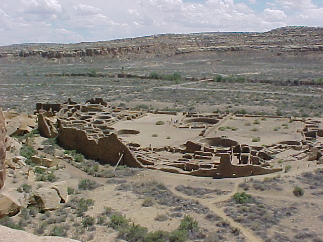
labor to build and maintain. Similar to the pueblo building in Chaco and the mound building at Cahokia, this meant that a stratified social system developed where many people undertook construction projects that supported the elite.

The plants and animals brought by the sailing settlers in their out-riggers greatly contributed to survival. They introduced plants like taro, yams, breadfruit, paper mulberry (for clothing), and herbs, along with pigs, dogs, and fowl. To transport harvest to the coast and to trade with other chiefdoms, the people of the ahupua'a constructed elaborate trails. These trails connected diverse communities, royal lands, sacred sites, and resources both between and within the ahupua’as. People walked from the coastal villages to the upland gardens to gather food, to seek help from kahunas, and to appeal to royalty.


Religion permeated pre-contact Hawaiian life. Prayers blessed significant events, celebrations, and seasonal observances to ensure individual and community health, success, and prosperity. Hawaiian gods split into two groups: the akua were animist spirits connected with natural forces while the ‘aumakua represented ancestral gods. The four main Hawaiian gods were Kane, the primary god and creator of all things; Ku, connected with the abundance of the earth as well as with politics and war; Kanaloa, god of the sea and of death; and Lono, god of rain, agriculture, and fertility. In addition to these main gods, hundreds of lesser deities populated the land, including the famous Pele who ruled over volcanoes.

Kahunas (human priests) communicated with the gods and spirits. These shamans mediated with the deities for humans, healed people, and legitimized a chiefs’ power by declaring divine provenance. As with all pre-contact cultures that we have looked at in this section, religion played a major role in everyday life. Praying to spirits who controlled rain in the desert Southwest or volcanoes on the Hawaiian Islands was an intimate act of convergence with powers bigger than humans.  
King Kamehameha II


King Kamehameha I
English explorer Captain James Cook made first European contact with the Hawaiians in 1778. He and his ship visited the islands several times as they sailed around the Pacific. Change happened quickly after contact. In 1819, Kamehameha the Great died and, Kaʻahumanu and Keōpūolani, two of his wives, convinced the young king Kamehameha II to overthrow the kapu system. Consequently, Kamehameha II sat down with his mother and ate a meal, breaking the kapu. Additionally, people burned many of the wooden statues and tore down some of their rock temples. On the heels of the overthrow of the kapu system, in 1820 missionaries from Boston arrived and began to convert the islanders to Christianity. Native religion and traditional practices came under assault and while some of these beliefs survive on the islands today, they were suppressed for decades. Few pu'uhonuas survive, thus the historic site at Pu'uhonua o Honaunau is one of the best preserved and illustrates the rich texture of religion and industry of the first Hawaiians.

Pu'uhonua o Honaunau National Historical Park National Historical Park,
State Highway 160, 
Honaunau, Hawai'i  
(808) 328-2326  

Conclusion for Section One: Precontact Americans.

The pre-contact Americans that we visited at the five NPS sites in this section show sophisticated societies that grasped the complex world that we live in—from plotting the passage of the sun, moon, and planets, to managing and protecting fragile eco-systems. They developed extensive trading networks that transported plants, animals, and goods across thousands of miles of challenging landscapes and oceans. They organized their communities, both large and small, into a variety of social structures that rivaled the feudal kingdoms of Europe at the time, and they embarked on ambitious public works of large earthen mounds, of massive multi-storied pueblos, and of structures aligned to the movement of the heavens. Their built environment served as a cosmic clock. Pre-contact peoples also believed in a world animated with spirits that protected families, ensured good hunting, provided rain when needed, and healed them.

The 500 nations of North America had abundant foods unknown to the rest of the world. Corn, potatoes, chile, chocolate, tobacco, and tomatoes testify to their skills as agricultural scientists and experimenters. With a population equivalent to Europe at the time, people in the Americas had vibrant, interconnected, sophisticated civilizations that rivaled what was going on worldwide, except for three items. They did not have metal tools. They did not have large draft animals. And they did not have immunity to European diseases. In the next section about the NPS sites that chronicle the contact with Europeans and then Colonial America, we explore the encounter of different cultures which produced our United States. This contact impacted both Native peoples and Europeans and indeed, transformed the world that we live in.


Monday, February 22, 2016

Colonial National Historic Park at Yorktown, Virginia

Jamestown before the English

            Let’s now turn to the native peoples of the Atlantic coastal region in our histories of pre-contact Americans. In the lush woodlands that blanketed the eastern part of the continent, hundreds of tribes and thousands of communities lived and used this rich region. We will look at the Algonquin who lived in the southern coastal plains of Virginia, on the land that will eventually host the first permanent English colony at Jamestown.
Several distinctive Native American groups populated the eastern woodlands of North America. Human bones found at Cactus Hill, Virginia prove that people roamed this region at least 16,000 years ago. Before contact with Europeans in the 16th century, the Algonquin comprised the largest group, living in an area that extended from Hudson Bay to the Atlantic. Because of the temperate climate and abundance of rainfall, this region produced more food than any other part of the continent. Other tribes contested this fertile land, especially the Sioux and the Iroquois. Ownership of contested places and coveted resources often resolved itself through battles which changed homelands and forced migration to other parts of the continent. For example, originally the Algonquin lived around the Great Lakes region but due to conflict or drought or something else, they moved to the Atlantic coast, first about 2,000 years ago with another wave around 1,200 year ago[1]  

Map of the Algonquin World (from exhibit at Historic Jamestowne NHP)

The Algonquin

Like many other pre-contact tribes, the Algonquin changed from hunters and gatherers to farmers sometime around 2,000 years ago. And as with the other tribes, corn proved the key. With the improved diet from corn and the resultant population growth, the Algonquin developed increasingly complex societies which required more social organization and cooperation. Chiefs controlled commerce and collected tributes of crops and other goods.
Their social structure placed the chief and sub chiefs (werowances) at the top followed by warriors, priests, and commoners. Under a supreme chief who ruled over multiple villages and communities, a “paramount” or confederacy evolved where the werowances received tributes from their subjects and then gave tribute to the supreme chief. As Stephen Potter observes in Commoners, Tribute, and Chiefs:  “The rank of chief gave them the authority to direct labor and gather economic surpluses, resulting in two economies—the political economy of the chiefdom and the subsistence economy of the supporters’ households.”[2] When chiefs died, their wealth followed their corpses into the mortuary mound, perhaps a remnant of the earlier Moundbuilders who shared the Algonquin language.  
In addition to the chiefs controlling natural resources such as crops, game, and the bounty of nature, they also managed the trade networks that ran through their lands. Archeologists have discovered rhyolite tools on the south coast of Virginia made from stone quarried near Gettysburg, Maryland. Skilled stone-workers dug out the rhyolite and then chipped it into blanks.  Traders carried the blanks south in backpacks woven from reeds or made from skins. In the paramount of the Potomac Valley, flint knappers shaped the blanks into projectile points, spears, scrappers, and other tools necessary in a non-metal world.
Imagine a small group of traders walking hundreds miles with backpacks full of goods. Maybe they traded corn or dried fish for the rhyolite. Perhaps they mined it themselves before heading back. As with the Moundbuilders and the Chacoans, the Algonquin traveled over a wide network of trails and terrain to trade with others near and far.
Supporting their world view, the Algonquin developed a complex religion. Gods and spirits divided into two major groups: Ahone was the creator and giver of good things and their main deity.  Ahone did not seek offerings or sacrifices. Okee was often associated with war and strife and unlike Ahone, offerings such as tobacco, beads, fur, or food could appease this sometimes vengeful god. To facilitate exchanges with the gods and spirits, two hierarchies of priests presided over the faithful. The higher priests insured the proper performance of rituals and held the tribal memories and history. The lower caste of priests administered to more local concerns such as curing the sick with herbs, chants, and sweat lodges and defending their communities.
Tobacco held an important role in religious observances. To appeal to Okee and other spirits, tobacco was thrown into a fire. Prayers attached to exhaled smoke hopefully were carried to sympathetic spirits. Clay pipes found at excavations have small bowls, perhaps because the native tobacco in the Virginias was a harshly strong herb.

The Powhatans

Let’s focus on a specific Algonquin tribe. One of the prominent Algonquin sub-groups before contact with Europeans was the Powhatans, who lived along the tidewater in southern Virginia. The Powhatans called their land Tsenacomoco. The paramount chief of the Powhatans, the Mamanatowick, ruled his people through marriage alliances, diplomacy, and force. At the beginning of the 17th century, his chiefdom included thirty tribes and approximately 15,000 people.
Algonquin Mother and Child
            Women had large responsibilities in this culture. Algonquin families were matrilineal where inheritances passed down from the mother. Houses were built by women, who may have owned them. Powhatan women cooked, gathered wood for the constant fires, reared children, sewed clothing, planted and harvested, and made baskets, pots, and other household items. Besides collecting edible plants, they also processed the meat from hunts and tanned the hides.
Most marriages occurred at puberty, and the groom paid a bride price to her family to make up for the loss of her labor. Men could marry as many women as they could support. Both men and women adorned their faces with red or blue paint and nut oil, and women tattooed themselves.
The Powhatans had a semi-nomadic cycle of moving around an area to take advantage of the resources, dictated by the seasons. During the winter months, called Popanow, they hunkered down to survive the lean times. Once Cattapuak, or Spring, arrived, they left their winter villages and fished, hunted, gathered early plants, and planted corn, squash, beans, and other crops. The March through May oyster hunts often provided fresh nutrition for hungry people and dried meat for later eating. Cohattayough, or Summer, saw the Powhatans living in portable wigwams and fishing for sturgeon, salmon, alewife, cod, smelt, trout, striped bass. They even hunted whales, porpoises, and seals from their log and birch bark canoes. They stockpiled food for the winter. Fall, or Nepinough, called for reaping the corn, squash, and beans while late Fall, or Taquitock, witnessed communal gatherings with up to 200 tribal members hunting and processing the deer kills. They also hunted beaver, moose, caribou, geese, ducks, and other animals.  Women and children collected scallops, mussels, crabs, and other shell fish as well as nuts and berries.
            The Powhatans on the eastern seaboard mainly grew the Three Sisters of corn, squash, and beans, but also cultivated potatoes, peppers, and tobacco. They planted the Three Sisters together in their fields with the corn providing stalks for the climbing bean vines and the squash growing underneath this green canopy.

Wigwam made out of animal hides (Photo by J. Hunner)

Inside of a Wigwam at Jamestown Settlement (Photo by J. Hunner)
         When winter arrived, the Algonquin gathered together in large camps and built bark or mat covered long houses that held four or five families. The months of February and March often tested them as food and fuel might dwindle. Cached food in semi-subterranean structures provided sustenance and hopefully prevented starvation. At a site near the Patuxent River in Virginia, archeologists excavated a large storage pit and found oyster shells, broken pottery, and stone tools. Another storage pit on the James River revealed the remains of fresh water mussels, whitetail deer, turkeys, turtles, sturgeons, and gars. Other items in these pits include angled clay pipes with incised designs, shell gorgets with drilled dot designs, and small shell masks of stylized human faces often with a thunderbolt or tear descending from the eye.  These excavations give us insight into what the Algonquin ate and how they lived.
            The Paramount of the Powhatans which covered the fertile coastal plains of Virginia was a large confederacy of Algonquin, regulated by their seasonal activities and also by their priests and their chiefs. At the turn of the 17th century, this was a powerful paramount, a healthy collection of people based in agriculture but also connected to other parts of the East Coast through trade and diplomacy. The Mamanatowick, the supreme chief of the Powhatans in the coastal area of Virginia, had a daughter named Amonute, whose life changed history. In a future chapter on the English colony at Jamestown, we will look at her more closely. Because of her lively nature like turning cartwheels, people nicknamed her “the playful one,” or Pocahontas.
           
An Algonquin Village 

            Today, many people identify with the various Algonquin peoples. Some of the many tribes that have Algonquin roots are the Cheyenne, Cree, Creeks, Delaware, Fox, Kickapoo, Mahican, Menominee, Mohegan, Ojibwa, Pequot, Pottawotomi, Powhatan, Sac, and Shawnee. Eight tribes are recognized by the state of Virginia as having ancestral ties to the Powhatan confederation: the Upper Mattaponi; the Chickahominy; the Eastern Chickahominy; the Nansemond; the Rappahanock; and the Monacan Nation. The Pamunkey and Mattaponi are the only two peoples in Virginia who have retained at least some of their ancestral lands on reservations. At the end of the future chapter on the English colony at Jamestown, we will learn more about the creation of this historical park.
Swamp on Jamestown Island (Photo by J. Hunner)

Colonial National Historical Park
P.O. Box 210
Yorktown, VA 23690
757-856-1200

Related Sites:
Jamestown Settlement: http://www.historyisfun.org/jamestown-settlement.htm.


[1] Potter, Commoners, 3.
[2] Potter, 169.

Monday, February 15, 2016

Chaco Culture National Historic Park near Nageezi, New Mexico


On the plateau above Chaco Canyon rests the multi-room ruins of Pueblo Alto. The human made trail up the cleft in the canyon’s cliff and along the plateau dates back a thousand years. During the summer monsoon season with its afternoon thunderstorms, a person climbing up out of the canyon and hiking to Pueblo Alto sometimes dodges downpours and sees nearby lightning strikes. Standing in the ruins of Pueblo Alto, buffeted by wind, I saw a broad road sweeping north toward the Salmon and Aztec ruins some thirty miles away. In fact, Pueblo Alto is one of the gateways into Chaco Canyon, the end of a massive network of roads which funneled peoples and goods to this desert center from around North and Central America.
Artist's Recreation of Pueblo Bonito in 12th Century (NPS)
Set at 5,000 feet above sea level amidst a parched landscape which gets less than ten inches of annual rainfall, the Four Corners region of the Southwest holds a sparse beauty of earthy tones, hardy plants, and wide open spaces. Mountain ranges fifty miles away frame the horizons, and mesas punctuate the foreground like desert islands. Chaco Canyon cuts through the landscape with its mile wide trough which runs east to west for twenty miles. Scattered along the canyon floor and interspersed on the plateau tops are over a dozen major ruins and numerous smaller ones, all illustrating the many skills of the Chaco builders.

The Chacoans created a sophisticated civilization between 900 and 1200 Current Era (CE). They grew corn which like elsewhere transformed their ancestors from hunters and gatherers to farmers. To this day, Native Americans in New Mexico talk about the three sisters of food—corn, squash, and beans. Perhaps the most important of these sisters is corn, sometimes called the Corn Mother. Other foods, unknown to the rest of the world, also developed in the Americas. Squash, beans, chiles, manioc, potatoes, chocolate, and tobacco are some of the unique crops that provided healthy nutrition. In fact, these foods provided Americans a better diet than the Europeans had at the time. Once these crops crossed over to Europe, they continued to revolutionize people’s lives with better nutrition and even prevented starvation. We will explore this “Columbian Exchange” more in a later posting.

As the largest complex in the Chaco valley, Pueblo Bonito had 650 rooms spread out over two acres in a D shaped structure. The long edge of the D faces south for solar gain but also for the important orientation along the cardinal points treasured by the Chacoans. Pueblo Bonito, with its earliest construction begun in the 10th century, rose five stories. Until the 20th century, Pueblo Bonito was the largest built structure in the United States.
Pueblo Bonito (Photo by J. Hunner)

Room at Pueblo Bonito with vigas (Photo by J. Hunner)
It grew over three centuries in a way that entailed planning on a complicated and massive scale.  Take for instance the wood roof beams (or vigas). Excavations of the earliest vigas show that they came from nearby piñon trees. The Chacoans quickly deforested the piñon trees so they had to go to the nearby mountain ranges for their timber. At the Chuska Mountains some fifty miles west, work crews felled large Ponderosa Pine trees with stone axes. While still green and soft, Chacoans chopped them up into the right size for the various rooms. The vigas then dried for two years to make them lighter to carry. Men then carried these logs fifty miles and built the rooms of the great pueblos and kivas at Pueblo Bonito. Archeologists estimate that 215,000 vigas were used in building the Great Houses and the other structures in Chaco Canyon.

In the middle of the pueblos’ plazas and interspersed among their numerous rooms are often circular kivas where clans gathered to worship, socialize, teach, and work. At Pueblo Bonito, thirty-five kivas grace the ruin. These numerous places show that the Chacoans were likely a deeply religious people.
Kiva at Pueblo Bonito (Photo by J. Hunner)
For decades, archeologists have wondered why humans established a dense urban complex in a harsh desert setting. Some have speculated that the canyon served as a distribution center to share the harvest around the Chacoan region to communities whose crops had failed. Others proposed that it was a seasonal ceremonial center, visited by a large number of peoples from the outlying communities spread around the region. A peculiar fact uncovered by the archeologists is that there are relatively few burials at Chaco Canyon. They concluded that the large pueblos with hundreds of rooms housed only a couple of thousand people, whose population swelled during the seasonal periods of ritual and festivals.

Here’s where it gets pretty interesting. Rising up out of the east end of the canyon lies Fajada Butte, a tall lone mesa where Anna Sofer found a spiral petroglyph she calls the Sun Dagger half way up the mesa. This spiral, carved into a rock hidden behind three large slabs, is a time keeper. A dagger of sunlight bisects the shadowed spiral on the summer solstice. At the equinoxes, a dagger of light frames the spiral. On the solstices and equinoxes, signal fires spread the news to the whole Four Corners region. Using their built environment as time pieces, the Chacoans had a precise seasonal calendar.
Slab casting sunrise shadow on spiral with inset of Sun Dagger (Photo from www.solsticeproject.org/lunarmark.htm)
Some Chaco buildings perform an even more amazing feat: they track the 18.2 year progression of where the moon rises in the east. At the pueblo of Chetro Ketl on the canyon floor, one of the walls runs along a straight line for about 300 feet. This alignment points to the spot on a nearby cliff where the moon rises on the farthest northern point of its 18.2 year cycle. Few if any other buildings in the world orient so precisely to this subtle lunar cycle.

Prehistoric Stairways climbing out of the Canyon 
Roads radiate out from the canyon as straight avenues. Ancient stairs carved into the cliff faces funneled people into and out of the canyon where they then used eighteen feet wide roads lined with stone curbs to travel to the over 150 other Great Houses and beyond. Sea shells from the Pacific Ocean, soapstone from the Midwest, and amazingly, parrot feathers from the tropics of Central America have surfaced in the excavations at Chaco.  For example, in 1941, park personnel, wanting to stabilize a cliff face that towered over Pueblo Bonito, cleaned out the cleft at the base of the cliff. After they removed the rock and debris, they found a Macaw parrot feather used as a prayer stick deposited there 1,000 years ago. They removed that too. Within a couple of months, this part of the cliff calved off and smashed a section of Pueblo Bonito. Parrot feathers, soapstone, seashells provide evidence that Chacoans traded with faraway places.


Chacoan Road network (Map by USGS)
The end of the human habitation at Chaco Canyon lies in as much mystery as its purpose. Here’s some theories: perhaps communities collapsed as a fifteen year drought around 1150 fried the region’s corn fields. Or perhaps warfare doomed the culture, as a new wave of migrants swept forcefully through area. Whatever the reason, the Ancestral Pueblo peoples left in a well ordered manner. Kiva roofs came off, and the vigas set on fire. This took weeks to do which indicates that the end of Chaco was not a panicked retreat, but an orderly and, not surprisingly for the master builders of the Southwest, planned event.

The diaspora from Chaco spread to all directions. When they left the Chaco region, the Ancestral Pueblo people migrated to places with more abundant and steady sources of water like the San Juan River to the north and the Rio Grande to the east. Many of the modern pueblos in New Mexico and Arizona are descendants of the Chacoan people.

Pot hunters in the late 19th century destroyed the ruins looting the valuable artifacts left behind by the Chacoans. Protection and preservation began with Richard Wetherill, an amateur archeologist and cowboy. He hired 100 Navajos to help with his excavation of the ruins and sent more than 60,000 pieces of turquoise, pottery, and stone tools to the American Museum of Natural History on the East Coast.

In 1907, President Teddy Roosevelt created the Chaco Canyon National Monument under a provision of the Antiquities Act of 1906.  Chaco Canyon then became part of the NPS at its creation in 1916. In 1987, UNESCO designated Chaco as a World Heritage Site.

Walking through the impressive ruins of Chaco Canyon, climbing out of the valley on ancient stairs 1,000 years old, hiking across the desert plateaus on wide roads lined with boulders to outlier complexes, I feel in awe of the people who lived here so long ago. With stone tools, they fashioned a complex civilization which documented the movement of the heavens and passage of the seasons with the alignments of their large structures. They built roads to bring their far flung peoples to the canyon and to trade with other civilizations 1,500 miles away. It is one of the most amazing and inspiring places in the United States.
Fajada Butte looking southwest (Photo by J. Hunner)
Chaco Culture National Historical Park
Box 220
Nageezi, New Mexico 87037
505.786.7061
www.nps.gov/chcu

Related NPS sites:
Aztec Ruins National Monument, New Mexico
Bandelier National Monument, New Mexico
Canyon de Chelly National Monument, Arizona
Casa Grande Ruins National Monument, Arizona
Gila Cliff Dwellings National Monument, New Mexico
Mesa Verde National Park, Colorado
Petroglyph National Monument, New Mexico
Salinas Pueblos Missions National Monument, New Mexico

Monday, February 8, 2016

Hopewell Culture National Historic Park at Chillicothe, Ohio

In the early light of dawn, the landscape at Hopewell NHP undulates with mounds hidden by mist and hardwood trees. Some of these mounds date back to 2,000 years ago and testify to the sophisticated culture created here, a culture that in ways, equaled the ancient Romans of the same time period. How did humans come to this part of the continent and what kind of civilization did they develop?  These are some of the questions that this and the next three postings of Driven by History will focus on. We will visit NPS sites connected to native peoples and ancient cultures to see how Americans lived before contact with Europeans. We begin with the Hopewell Culture National Historic Park in Ohio, and in future postings, we explore the Ancestral Pueblo peoples of Chaco Canyon, the Algonquin on the Eastern Seaboard, and the Polynesian islanders on Hawai’i.

Once people arrived in the Western Hemisphere, they spread over the landscape like water through a burst dam.  They roamed the countryside, hunting and gathering their way from the frozen tundra near the Bering Sea to the equally cold tip at Tierra del Fuego on the southern continent, from the steamy jungles in the tropics to dense woodlands and from mountains to beaches to swamps to deserts. Natural barriers like bodies of water or mountains which prevented easy traveling could only be crossed when rivers froze or high passes  thawed. In whatever way humans came to the Americas, once here they migrated over the countryside as their bands grew and like migrants today, they looked for the perfect place to live and thrive.

Throughout all of these periods, humans worked nodules of flint and obsidian to fashion some of the most refined stone tools and weapons in the world. They crafted a way of living that continues to amaze. They hunted large mammals like mammoths and bison with spears and harvested most of the carcasses for food, clothing, tools, and shelter. With sharp stone edges, they trimmed hide into clothing. They wove sandals out of fibrous plants, carved and painted art on rock walls, and made religious and ornamental objects out of shells, turquoise, bones, and even the landscape itself. These humans also studied the heavens and developed a complex understanding of the movement of the sun, the moon, and the planets. They flourished for thousands of years and eventually, hundreds of generations lived in all corners of what would be become the United States.

Isolated from the rest of the world once the Arctic land bridge sank due to global warming, humans in the Western Hemisphere evolved differently than the rest of the world. In his book 500 Nations, Native American historian Alvin Josephy, Jr. explained this differentiation:  as the indigenous peoples of the Americas “adapted to the different environments, cultural and physical variations began to appear among them.”[1] Eventually, these early Americans’ unique responses to where they lived evolved into the 500 distinct tribes that spread across the land.

The people who lived at Hopewell, in the central part of North America, developed a woodland civilization. Southern Ohio served as the cradle of Hopewell culture which expanded along the tributaries of the Mississippi River as far west as today’s Nebraska and Kansas and as far south as the Gulf of Mexico. Archeologists call these people by several names, including Adena, Hopewell, Late Woodland, and Mississippians.

As early as 1500 BCE, people in the area began burying their dead with items that showcased the skills and artistry of their craftspeople, and by 1000 BCE, they started building mounds over these graves. Copper earspools, headdresses, breastplates, and other ceremonial objects and tools along with effigy pipes of birds and other animals found in these burial mounds illustrate the exquisite workmanship and wealth of the Hopewell people. In one mound, archeologists found a delicate profile of a hand while in another, they discovered a bird claw, both made out of fragile mica.
Mica hand found in a mound (NPS photo)

Mica bird claw and other artifacts from mounds

These funeral objects also hint at a deeper motivation – a spirituality that pervades the 500 nations in the Americas. From origin beliefs to migration stories, Native Americans imbued their world with a rich spirituality. From such stories, Josephy concluded: “The Creator, the Master of Life, the Great Spirit, Wakan Tanka—whatever terms the various Native American groups used – breathed life into humans and bound their spirits to those of all else in their universe.”  For many of these peoples, both animate and inanimate things possessed a spirit and even a consciousness that enlivened all that surrounded them.

The objects found in the burial mounds give us a glimpse of the Hopewell way of life. Sea shells from the Gulf of Mexico, mica from the mountains in North Carolina, fossil shark teeth from the Chesapeake Bay, copper and silver from the Great Lakes region, and obsidian from Yellowstone area point to a vast trading network that covered almost two thirds of the country – from the Rocky Mountains to the Atlantic.
Mounds at Hopewell (NPS photo by Tom Engberg)

The most important item that allowed people to develop their complex civilizations throughout the Americas came to the woodlands region around the beginning of the Current Era. Corn cultivation changed human existence in the Americas. Developed in what is now southern Mexico about 7,000 years ago, corn (maize) is a unique plant. Disagreements exist over how corn evolved, but the main point is that it since a tough husk engulfs the cob, corn can’t sow itself. An outside agent, like people, have to do it.

As Charles Mann notes in 1491 (his book on the Americas before Columbus): “Modern maize was the outcome of a bold act of conscious biological manipulation— ‘arguably man’s first, and perhaps his greatest, feat of genetic engineering’.”   One corn seed produced hundreds of kernels on multiple cobs and allowed a farmer to produce enough food on a small plot to feed a family for a year. This revolutionized agriculture, and as corn spread north and south from Central America, it transformed hunters and gatherers into farmers with improved diets. In addition to corn, the Mound Builders also grew squash, sunflowers, marsh elder, and knotweed while continuing to hunt and forage far and wide for food and material.

Archeologists speculate that this culture developed strict hierarchal lines with an elite body of priests and managers directing the efforts of many people to dig the earth, carry basketfuls of the dirt to the mounds, and build the massive earthen architecture that rose high over the land. Whether this was free or slave labor is unknown. From the simple early burial sites of 2,000 years ago, the mounds evolved into elaborate platforms for ceremonies and even served as residences of the elite. Large ceremonial complexes grew around the mounds so much that archeologists estimate that the Cahokia mound complex east of St. Louis had more people than London in 1250 CE. 
Monks Mound at Cahokia (Photo by David Darling)

Some experts also speculate that the mounds housed astronomical observatories that tracked the seasons. Perhaps the mounds served as landscape calendars and were aligned to mark summer and winter solstices and equinoxes. In an agricultural society without written calendars, having a way to announce the turning of the seasons, of when to plant and when to harvest, prove vital to the success of the community.

Mounds in a variety of sizes and shapes unified this culture. Some mounds rose over thirty feet high and up to two hundred feet in circumference, and just in the Ohio River Valley alone, ten thousand mounds dotted the landscape. In addition to the traditional circles, squares, and elliptical shapes of the mounds, some assumed intriguing shapes. These “effigy mounds” depicted birds, serpents, panthers, bears, and even humans. Built between 700 and 1300 CE, these intriguing shapes occurred mainly in Iowa, Illinois, and Wisconsin. This was a vibrant and interconnected society.
Marching Bear Mounds at Effigy Mounds NM (NPS photo)

The Mississippians started to decline even before contact with European explorers in the middle 1500s. Whatever the cause, the Mississippians are considered to be the ancestral peoples for many of the tribes that have lived in the region, even to this day. The tribes of the Apalachee, Caddo, Cherokee, Chickasaw, Choctaw, Creek, Houma, Kansa, Missouri, Mobilian, Natchez, Osage Nation, Quapaw, Seminole, Yamasee, Yuchi, and others trace their ancestry to the Mississippian mound builders.

The people who lived and developed their communities in the central part of the United States laid the foundation for a vibrant and varied collection of tribes. Agriculturally based, they positioned their mounds to mark the passing of the seasons, they were connected to a vast network of trade and commerce, and they had a stratified social structure that included priests and rulers supported by craftsmen, farmers, and possibly slaves. As we continue our exploration of pre-contact Native Americans and their NPS parks, we will next traverse 1,200 miles to the desert southwest and to the Chaco Culture National Historic Park.

The Mound City Group National Monument was established by President Warren G. Harding in 1923 to preserve prehistoric mounds of "great historic and scientific interest." Hopewell Culture National Historical Park was established in 1992 by renaming the Mound City Group National Monument and expanding the park to include Hopeton Earthworks, High Bank Works, Hopewell Mound Group, and Seip Earthworks.

Hopewell Culture National Historic Park
16062 State Route 104
Chillicothe, Ohio, 45601
(740) 702-7677
www.nps.gov/hocu


[1] Alvin M. Josephy, Jr., 500 Nations: An Illustrated History of North American Indians (New York: Alfred A. Knopf, 1994), 17.

Monday, February 1, 2016

Bering Land Bridge National Preserve near Nome, Alaska

Standing on a windswept beach in Alaska gazing west across the thundering surf toward Asia, the imagination sparks to envision humans entering the Americas at this place. Sometime between 20,000 and 13,000 years before the present, stone-age humans followed migrations of big game animals and occupying caves and camp sites in the Western Hemisphere. Theories on how and where this happened have engaged archeologists, linguists, geneticists, geographers, anthropologists, and climatologists for decades. At this wind tossed, mist shrouded beach on the Bering Strait, we will speculate how humans first arrived on the shores of what would become the United States.

The story of human migration into the Americas is a complex story, one of evidence (and lack thereof), of conjecture, of belief, and of debate. Common knowledge holds that roving groups of hunters and gatherers journeyed across a land bridge from Asia to Alaska. These people then spread out south through ice-free corridors that opened between retreating glaciers around 13,000 years ago. After escaping the ice, humans quickly spread across the northern, central, and southern sections of the hemisphere, adapting to the varied landscapes and environments they encountered. This narrative, popularly known as the Bering Land Bridge theory, offers a compelling explanation on how the first peoples arrived here.

Doubts hover around this theory. Was there just one wave of migration across the Bering Land Bridge or several waves? Did people from other places besides Siberia- perhaps from Europe or Polynesia- also find the shores of the Americas? Did humans arrive by boat instead of on foot? Once here, how did people change the landscape? And finally, what do descendants of the first Americans say about their origins? As archeologist Dr. Beth O’Leary says: “It’s complicated.”

Let’s go through the evidence about the Bering connection. During the last period of world-wide glaciation (from 75,000 to 11,000 years ago), the sea level dropped as massive ice sheets locked up much of the world’s water. As sea levels dropped, a land bridge emerged between Asia and America, stretching from the Chukotka peninsula in Asia to the Seward Peninsula in Alaska. The first mention of a land bridge occurred in 1590, when a Jesuit missionary to Latin America, José de Acosta, speculated that such a connection between Asia and North America allowed humans to enter this continent. By the 1930s, evidence established the existence of the land bridge so that in 1937, botanist Eric Hultén dubbed the land bridge “Beringia.” Later scholars broadened the definition to include northeastern Siberia and western Alaska.[1]

Climatologists estimate that a 600 mile wide land bridge connected the sixty mile gap between the continents. This isthmus eventually sank under the rising waters as glaciers melted sometime around 12,000 years before present (BP) -- give or take a few thousand years.
Unfortunately, the glaciers that caused the land bridge would have blocked further migration as the ice swallowed whole valleys and smothered the mountains in Alaska and western Canada. These glaciers retreated, and an ice door opened around 13,500 years BP. So humans could have crossed to America on the Bering land bridge, but unless they traveled over the treacherous glaciers in journeys that might have taken weeks if not longer, they remained blocked at the entrance to the New World.

Now here is the dilemma. Caves in Monte Verde, Chile, and Meadowcroft, Pennsylvania, have produced carbon dating of objects that shows humans entering into the Americas 13,500 years BP. The cave in Chile by some testing dates back to around 15,000 years BP and the cave in Pennsylvania from 14,000 to 12,500 years BP.[2] Other sites of human occupation at Cactus Hill and Saltville, Virginia and the Topper site near Savannah, Georgia, also could predate the opening of the ice corridor from Alaska into the rest of North America.[3] With the passage south into the rest of the hemisphere blocked by ice from around 25,000 years until 13,500 years BP, humans either survived the trek over the glaciers, or they came a different route. They might have come by sea, either along the coast of the land bridge, or across the Pacific Ocean as an extension of Polynesian explorers, or even from Europe.

Navigating small boats that held ten or fifteen people over the thousands of miles of the Pacific or across the frigid waters from Europe to Iceland and Greenland, and then to North America seems unlikely, but humans did get to the Easter and the Hawaiian Islands in such a manner. Paddling along the coast of Beringia in hide-covered boats and living off of the marine animals that proliferate there seems more likely. Using boats to spread down the Pacific coast into South America and the cave at Monte Verde makes sense. So navigating the coastlines from Asia into Alaska and then down the western Americas to Chile, while daunting, helps resolve the dilemma; however, we have no camp sites or other evidence to prove this, mainly because such sites if they do exist, lie underwater, drowned by the rising sea levels as glaciers melted.

Genetics provide some clarification of the dilemma. Analysis of the founding DNA lineages for Native Americans estimate that humans expanded into the Americas from East Asia sometime between 18,000 and 16,000 years BP. So people must have already been below the northern glacial ice sheet before 13,500 years BP.[4] Additional DNA studies point to multiple waves of migration.

There exists enough of a variation in the DNA of today’s Native Americans in the Western Hemisphere that researchers speculate that people from different parts of Siberia and East Asia contributed to the peopling of the Americas. As Theodore Schurr concludes: “… both the mtDNA [mitochondrial DNA] and the Y chromosome data show evidence that more than one expansion contributed to the genetic diversity of modern American groups.”[5] Of course, as humans evolved in the western hemisphere and became distinct from their ancestors elsewhere, the evidence is mixed up in a dynamic and fluid mixture of strands of DNA like a bowl of spaghetti.

Scholars studying glaciers, climate, genetics, and ancient human sites generally agree that humans in the Western Hemisphere came from Siberia and East Asia in more than one wave of migration and fairly quickly spread out east and south to populate the land. Since human-made stone tools appeared in the East Coast before the Midwest and the Southwest, people probably had to skirt over the northern edge of the massive glaciers and eventually came south into the continent somewhere near the Great Lakes.

Once humans entered a region, they began to alter it. The concept of a virgin wilderness is a potent myth for the United States and the National Parks; however, with the first footstep, land turned into place, and people started to change it. Even though the First Peoples’ impact might seem minimal by today’s standards, they still changed the environment. From hunting and gathering to setting fires to the prairies, from managing water for crops which they planted to creating narratives and histories about themselves and their landscapes, people impact their surroundings. Humans have lived and altered this land for hundreds of generations.

What do Native Americans say about their origins? While some do talk about long migrations, few of these stories mention coming across water in boats or crossing ice fields.  Take for example the Indians in the Southeast and along the Mississippi River. They lived in complex civilizations with sophisticated understandings of nature and the cosmos. One of the creation narratives of the Choctaw mentioned a sacred mound at Nanih Waiya that they call “Big Mother.” At this mound, the Great Spirit created the first Choctaw who crawled out of the ground and into daylight.[6] We will explore the mound builders when we go to the Hopewell Culture National Historic Park.

Hopewell Culture National Historic Park (http://worldheritageohio.org/hopewell-ceremonial-earthworks/)
The origin stories of the Ancestral Puebloan people of the Southwest revolve around humans emerging from a world that is underground, where humans, animals, and spirits lived and talked with each other. From this dark underworld, people came out of an emergence hole called a sipapu. Some tribes set out on long journeys around the continent that lasted generations in search of the ideal place to establish a permanent settlement. The wandering tribes lived in a place for a while and then moved on. We will look at one of these intermediate sites when we explore Chaco Culture National Historic Park.
Chaco Canyon (http://galleryhip.com/chaco-culture-national-historical-park-camping.html)
The humans who sailed across the Pacific Ocean to land on the Hawaiian Islands had their own origin narratives. Kane, the god of creation, fashioned a man out of some rich, red earth and breathed life into him. Red Earth Man then begat Wakea and his wife, Lihau’ula, who also were descended from the gods Rangi Sky and Papa Earth. We will look at the indigenous peoples of Hawai’i in the chapter on the Pu’u’uhonula o Honauhau National Historical Park.


In many of the creation stories of the first peoples of North America, humans came from the earth, not from elsewhere, and definitely not across the Bering Land Bridge. In this brief accounting of creation narratives, we have only focused on four out of the hundreds of tribes in pre-contact America. Just as species evolved in unique ways in the isolated lands of the Western Hemisphere, so too did their cultures and beliefs, and they diverged from the peoples they left behind. The First Americans quickly spread over thousands of miles of plains, deserts, mountains, forests, and whatever other land forms they encountered. These humans also adapted to the new flora, fauna, and environments, and in response, they created unique foods that revolutionized diets, first in the Americas and then across the globe.  From Bering Land Bridge National Preserve, we will next travel to Hopewell Culture National Historic Park in Ohio.

The Bering Land Bridge National Preserve was proclaimed a national monument in 1978 and then a national preserve on December 2, 1980. It comprises 2.7 million acres in northwestern Alaska.
Bering Land Bridge National Preserve (NPS photo: Katie Cullen)

Bering Land Bridge National Preserve
Box 220
Nome, Alaska 99762
(907) 443-2522
www.nps.bela.gov


[1] West, American Beginnings¸149.
[2] Madsen, Entering America, 141-146.
[3] Madsen, Entering America,149-153.
[4] Madsen, Entering America, 219.
[5] Madsen, Entering America, 236.
[6] Lee Irwin, Coming Down from Above: Prophecy, Resistance, and Renewal in Native American Religions (Norman: University of Oklahoma Press, 2008), 32

Introduction


On the Road to America (Photo by Marcello Brivio)
"Driven by the Past" is an exploration of our country’s past by exploring the places where significant events happened. By visiting these places that forged our nation, by getting to know the people who created our country at those places, Driven by the Past narrates the story of the United States through the parks that illuminate our ideals and beliefs, that reflect our complex history, and that inspire us to love our country. We’re going on a road trip to our National Parks.

2016 is the 100th birthday of the creation of the National Park Service, and their centennial motto is “Find Your Park.” To celebrate this anniversary, I am traveling to and writing about as many parks as I can. From May to November, I will crisscross the country, visit places of sheer beauty and of momentous events, and blog about my experiences. Join me for the ride.

Here’s the plan.  Every week from now until mid-May, Driven by the Past will post brief histories of a National Park every Monday. We’ll begin with the Bering Land Bridge National Preserve to get a handle on how humans came into the Americas. Then we will visit Native American parks— Hopewell Mounds in Ohio, Chaco Culture in New Mexico, Jamestown (before the Europeans arrived) in Virginia, and  Pu’u’uhonula O Honauhau park in Hawaii. The pre-contact peoples developed advanced civilizations that rivaled those in other parts of the world. After surveying some of the peoples who lived here before the Europeans arrived, we will travel to El Morro, New Mexico for the Spanish Entrada into the desert, Jamestown (again) for the English jumping onto the shores of Virginia, the African Burial Grounds in lower Manhattan about colonial slavery, and Grand Portage in Minnesota for the French traders paddling through the waters of the continent.

In May, all this changes. I hit the road for the rest of the year. I will visit National Parks in the West, in the North, in the East, in the South. Along the way, I will continue to blog about the parks, about their significance, about their beauty, about what people did there, and what people still do. So come join the journey and travel with me to our national parks.

At this point, when I say join me, I want to be clear that I’m not personally inviting all of you to ride in my RV and visit all of these places. Not that I wouldn’t want to travel with you all…. On second thought, why not? I think we’d all find that very interesting. So come along and show me your park.

The first leg of the road trip is through the West—going down the Santa Fe, Oregon, and California Historic Trails, tromping over the hills at Little Big Horn, seeing the thermal abundance at Yellowstone, feeling geologic time at Yosemite and the Grand Canyon. We will also visit pre-contact Native American sites, frontier forts, World War II parks, and many other units of the NPS.

Then, in the fall, I will head east and south and encounter awe inspiring Native America places, colonial and revolutionary war sites, parks about nation building, industry, immigration, war, and expansion. We will visit places where momentous events happened, events that shaped our nation and ourselves.

In writing these histories, I am literally driven by history. I have put on thousands of miles as I visit the far flung historical jewels of our national parks. Driving those long hours allows me time to ponder what I have witnessed, to analyze what it means, and to figure out how to tell the story of our country. From my windshield musings, three themes emerge that are interwoven throughout our nation’s pasts: mobility, exchange, and innovation. We are a country of  inventive immigrants, from the first humans who set foot in the Americas to European colonists to people today who seek our shores. Whoever we are today, wherever we live, whatever we believe, however we support ourselves, whatever lessons we pass onto our children originate in our many pasts. Despite our nation’s focus on the future, we are products of our history.We are as driven by our past as we are motoring through the present.


So come join these journeys across our nation and through our past. We will drive the land, write about the parks, and get to know our country and ourselves.Come drive into the past with me. I mean it. Each and every one of you. Wow! That’s a lot of people, we'd better get started.