Translate

Monday, March 21, 2016

Historic Jamestowne at Colonial National Historical Park at Yorktown, Virginia

Historic Jamestowne

First Successful English Colony

On the shores of tidewater Virginia, on May 13, 1607, three wooden sailing ships from England landed. The Susan Constant, the Godspeed, and the Discovery left London on December 20th, 1606 and after stops at the Canary and Caribbean Islands, arrived in North America. The three ships searched the James River and after several weeks, selected an isolated upriver island. As the ships tied up to the trees on Jamestown Island, 104 men and boys disembarked to establish the first permanent English settlement in North America.
Replicas in 2/3 scale of the ships at Jamestown Settlement (Photo by Hunner)
The English had failed previous attempts to establish colonies. In the late 1580s, they tried several times at Roanoke. While there, they named the land Virginia, after Queen Elizabeth I. Her successor, James I, granted a charter to the Virginia Company to settle the east coast. As a private business, the Virginia Company had to turn a profit and created two branches—the Virginia Companies of London and of Plymouth. The London branch founded the Jamestown colony while Plymouth held the land north of Virginia.
The English in 1607 faced a daunting challenge. They had to establish a viable community at great distance from England, amidst Algonquins who resisted the settlement, and at an unhealthy place. The nearby swamps bred mosquitoes and disease, and the brackish water sickened the colonists. Within six months of the first landing, fifty percent of the colonists had died, mainly from disease or accidental causes, but also from conflict with the Powhatan.
Swamp at Jamestown Island (Photo by Hunner)
Contested leadership plagued Jamestown from its beginning. Capt. John Smith, an adventurer, mercenary soldier, and an escapee from a Turkish prison, so angered his shipmates on the voyage that they put him in irons. The instructions from the Virginia Company opened at landing however named Smith as one of the leaders. The settlers first built a triangular Fort James on the banks of the river. The log palisaded compound protected the colonists and the English future in North America.
Model of Fort James within the compound (Photo by Hunner)

The Starving Time

In 1608, the “Second Supply” from England arrived on three ships which brought more than 100 men and boys, plus two women, and much needed provisions. The colony struggled through the winter and survived; however the resupply of the summer of 1609 went tragically awry. Nine ships set sail from England but a hurricane hit them, and the ship with the new leaders wintered in Bermuda. At Jamestown, the “Starving Time” gripped the colony. Lack of food and goods, attacks by the Powhatan, and diseases all felled the English. Cannibalism prowled through the community.
In April 2012, archaeologists found and analyzed the remains of a fourteen year old girl (nicknamed Jane) who had died during the Starving Time. They announced in May 2013 that Jane’s remains showed evidence of cannibalism. Cut marks on bones and a hole in the skull proved that after she died, her starving neighbors cannibalized her. At the beginning of the winter of 1609-1610, around 400 people lived at the fort. By the end of the next spring, only sixty had survived the Starving Time.
Jane's skull and reconstruction of her face (From http://www.sciencemag.org/)
In the spring of 1610, the ones alive abandoned Fort James and set sail for England; however, before they got to the Atlantic Ocean, they met the long delayed supply ships. Imagine the emotions of the Starving Time survivors as they were forced to return to the site of so much suffering. Return they did.
Jamestown quickly resettled, but the question of how to make a profit hung heavy over the Virginia Colony. For, while the crown supported the settlement in principal, it gave no money for the expensive colonization. Artifacts excavated from an early well illustrate their attempts at brewing, silk production, brick making, blacksmithing, collecting medicinal plants, and glassblowing. For example, in 1608, German and Polish glassblowers arrived to use the large amounts of wood and sand to make glass for export to London. Their early experiments to turn a profit failed.
Re-enactment of glassblowing at Jamestown (Photo by Hunner)

Tobacco Saves the Colony

Here entered John Rolfe and tobacco. He sailed in on the Third Supply, having spent the winter shipwrecked on the Bermuda Islands where his wife and daughter died. While on Bermuda, he purchased tobacco seeds. The taste for tobacco had swept Europe, and Spain imported the golden leaf from its colonies and so filled its own treasury. The Powhatan grew a harsh tobacco, not acceptable for export to the Europe. In 1611, Rolfe cultivated the sweeter tobacco of the Caribbean and sent four hogshead barrels of it to England. The tobacco shipment quickly sold out, and Virginia found a profitable export crop. This addictive substance turned the tide for Jamestown and secured its permanence.
Tobacco Field at Jamestown Settlement (Photo by Hunner)

Pocahontas

Pocahontas also helped make Jamestown permanent. As daughter of Wahunsenaca, the mamanatowick (paramount chief) of the Powhatan Chiefdom, she met the English soon after they arrived. In the winter of 1607-08, the Powhatans captured Capt. John Smith and brought him to the capital of the Powhatan Chiefdom. Perhaps Pocahontas (who was eleven or twelve at the time and the chief’s favorite daughter) saved Smith’s life by placing her head over his as it was about to be smashed. Whether the Powhatans truly sought to kill Smith or whether this was an elaborate ceremony of acceptance, Smith became an adopted son of Wahunsenaca.
Pocahontas resurfaced several years later with the other John in this story, John Rolfe. Relations between the English and the Americans worsened and hostage taking and combat spread. Capt. Argull kidnapped Pocahontas to force the Powhatan to release several captives and return stolen weapons. While a prisoner, she converted to Christianity, took the name “Rebecca,” and met John Rolfe. They married in April 1614 and the “Pocahontas’ Peace” halted the fighting between the Powhatan and the English for a decade. This peaceful period allowed the colonists to consolidate and spread to new areas of the coastal region.
Statue of Pocahantas at Jamestown (Photo by Hunner)
The power couple had a son, Thomas, and the Virginia Company decided to bring the Rolfe family to England to publicize the struggling colony. They arrived in 1616 with about a dozen Powhatan men and women. The English treated Lady Rebecca Rolfe like the royalty that this Powhatan noble was. In England, they toured the country and attended the theater where they sat near King James I and Queen Anne. Right before they returned to Virginia, Rebecca died. Thomas stayed in England and grew up with Uncle Henry Rolfe, while John and the Powhatan returned to Jamestown. Rolfe married again, but died on his plantation in 1622, possibly during the hostilities that broke out after the Pocahontas Peace collapsed. Warfare erupted off and on for years.
The Powhatan revolted again in 1644 when 350 to 400 of the then 8,000 colonists died. However, the English captured and killed the Chief which ended the Powhatan Chiefdom. These Native Americans then became subjects of the English crown. They continued to live in the East Coast with their descendants who are still there, but after the mid-1600s, their civilization waned under pressure from English weapons, from their draft animals, from their diseases, and from their growing population.
Map of the Powhatan Chiefdom (Photo by Hunner of exhibit at Historic Jamestowne)

The Oldest Representative Assembly in the United States

During the Pocahontas Peace, the Virginians created self-government. At the end of July in 1619, a General Assembly met at the Jamestown church. Representatives from all eleven regions of the colony debated how to create a governing body. Although hampered by a heat wave, Governor Yeardley on July 30th, 1619 called for the creation of the House of Burgesses. It has met continuously since, is known now as the Virginia General Assembly, and is the oldest representative legislative assembly in the Western Hemisphere.
That year, two other developments added to the peoples of the colony. The first Africans arrived at Jamestown to work in the labor intensive tobacco fields. From this small start, African labor grew in importance, especially after Bacon’s Rebellion. Also in 1619, ninety women arrived to help make the colony more permanent.
Like the Spanish colony in New Mexico, colonists held their Christianity faith closely. Reverend Bucke conducted the first Episcopalian service under a billowing sailcloth in May 1607. The Church of England, not as demanding nor evangelical as Catholicism, set the tone for the colony.
Mortality continued to lurk among the colonists, and church records document high infant mortality. Profits from tobacco with indentured and slave labor doing the field work and a carpe diem attitude from seeing so many family and friends die combined to give Virginia a fast paced, risk embracing society. By mid-17th century, Jamestown thrived.
Nonetheless, problems simmered. Tobacco experienced declining prices due to competition from Maryland and the Carolinas. Hailstorms, floods, drought, and hurricanes damaged crops. The indentured servant system (where men and women agreed to work for seven years in exchange for trans-Atlantic passage and then room and board) also contributed to the problems. Once they completed their indenture, the freemen often had to settle on the fringes of the colony.

Bacon's Rebellion

The spark that ignited Bacon’s Rebellion in 1675 started with an attack by the Doeg Indians against the Mathews’ plantation in the northern Virginia. Mathews had not paid the Doeg for some trade goods. In retaliation, Nathaniel Bacon, a recent arrival, organized almost 1,000 settlers to subdue the Native Americans. This unleashed an indiscriminate hunt for any Indians, including those loyal to the English. The frontier war then turned into a civil war as Governor Berkeley declared Bacon a rebel and attacked his headquarters. Bacon and his rebels descended on Jamestown and from July through September, 1676, controlled the capital. In early September, the Governor’s forces retook the capital, but not before Bacon and his men set fire to the statehouse, the church, and other buildings. As the colony reeled in turmoil, Bacon died, possibly of cholera, the rebellion fizzled out, and twenty-three rebels were captured and hung.
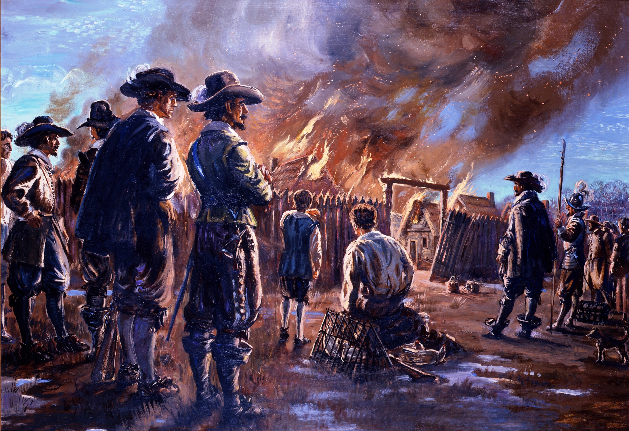
The Burning of Jamestown by Bacon and his rebels (Courtesy of NPS)
Since the indentured servant system fueled the rebellion, growers looked for new labor sources. Plantation owners now turned to African slaves as an alternative to indentured servants, both in reducing costs as well as in control of the workers. We will explore the issue of slavery in the colonies more in our next chapter on the African Burial Grounds in downtown New York City.
By the end of the 17th century, the capital of Virginia moved to the Middle Plantation, soon renamed Williamsburg. As the Europeans spread out over the coastal plains and into the Blue Ridge Mountains and as healthier places to live attracted settlers, Jamestown faded away; however, the first successful English colony established that nation's dominance on the East Coast.

The Association for the Preservation of Virginia Antiquities (APVA), founded in 1889, received the Jamestown church ruins and the twenty-two surrounding acres in 1893 from Mr. and Mrs. Barney, the owners of Jamestown Island.  In 1934, the National Park Service acquired the remaining 1,500 acres of the island. Ever since, Historic Jamestowne has been jointly managed by the APVA and the NPS as the Colonial National Historical Park in conjunction with the Yorktown Battlefield. In 2009, the APVA changed its name to Preservation Virginia. As a joint venture by the NPS and Preservation Virginia, Historic Jamestowne evokes the origins of our country, its colonial beginnings with democratic leanings, its dependence on indentured and then slave labor, and its complicated relationship with the indigenous peoples of the continent. We will return to the Colonial National Historical Park in the chapter on Yorktown, the defeat of the English army there, and the end of the British experience in the colonies.
Excavation in 2013 near the re-built Episcopal church (Photo by Hunner)
Entrance to Fort James on the banks of the James River (Photo by Hunner)


Colonial National Historical Park
P.O. Box 210
Yorktown, VA 23690
757.856.1200


Monday, March 14, 2016

El Morro National Monument and El Camino Real de Tierra Adentro National Historic Trail in the United States and Mexico

Contact between Americans and the Spanish


Traveling up the spine of Mexico and across the Chihuahuan Desert, Spanish explorers and then settlers pushed north from Mexico City, possibly following Native American trails. Forbidding deserts, waterless days, and harsh sun challenged the travelers. The interior lands can be an unforgiving landscape, especially as Contact between the Americans and the Spanish colonizers launched decades of war as well as exchange.

Spanish Encounter Native Americans

The Spanish made first contact with native peoples on the continent. In 1519, Hernán Cortés de Monroy y Pizarro marched on Tenochtitlan, the capital of the Aztec empire in Mexico and home to over 200,000 people. After two years of siege, the Aztec fell to Cortes, his soldiers, and their Indian allies. The gold and other treasures of the Aztecs fueled Spanish explorers who then found more gold in the Incan empire in Peru.
Tlaxcalan allies with Spaniards attacking Aztecs (Florentine codex 1579)
In the 16th century, Spaniards attempted colonies in Georgia, Florida, North Carolina, and Virginia; however, these efforts failed. Nonetheless, the Spanish believed that gold and other valuables waited in the far north of New Spain.

Francisco Vázquez de Coronado y Luján found no wealth during his expedition through the Southwest and into the Great Plains from 1540 to 1542.  These 300 Spanish were the first Europeans to encounter the Puebloan peoples, the first Europeans to see the Grand Canyon and the Colorado River, the first Spaniards to fight Native Americans at the Zuni and Tiguex pueblos, and the first to witness the nomadic Plains Indians chasing the bison herds in Kansas. Despite traveling over 4,000 miles from Mexico to Kansas and back, Coronado found no gold.
 
Coronado's Route 154-1542

Spanish colony of New Mexico

“Pasó por aquí.” “I passed by here.” In 1605, Don Juan de Oñate carved these words into the soft stone at the base of a windswept mesa in western New Mexico. Hundreds of Native American petroglyphs preceded Oñate’s inscription at the place the Spanish called El Morro (the Headland).

Onate's Paso por acqui engraving in 1605 at El Morro (Photo by Hunner)
Several years earlier, Oñate led 700 settlers north and blazed El Camino Real de Tierra Adentro (The Royal Road to the Interior Lands). This 1,500 mile trail from Mexico City to northern New Mexico opened up the Southwest to conquest, encounters, migration, and commerce. This trail linked New Mexico to the rest of the world for the next three centuries. Spain’s first successful colony in what would become the U.S. preceded the English’s one at Jamestown by almost a decade.

In July 1598, Oñate’s colonizing group  arrived in northern New Mexico and moved into a ruin near the Pueblo of Ohkay Owingeh. They arrived too late to plant crops, and in truth, few farmers had traveled with them. Instead most settlers knew mining, convinced that gold lay nearby. Consequently, the colony took food and clothing from the neighboring Puebloans. This made for strained relations.

Relations between the Spanish colonizers and the Puebloans worsened at the end of 1598. An exploratory party led by Juan de Zaldivar, Oñate’s nephew, sought to purchase corn flour from the people at the 1,000 year old Pueblo of Acoma. The Puebloans attacked and killed Zaldivar and many of his twenty soldiers, but several escaped by jumping off the mesa cliffs. In response, Oñate sent his soldiers to punish the Acoma people. A three day battle erupted around New Year’s Day 1599 and ultimately, the Spanish hauled up a canon to the mesa top and subdued the residents. In retaliation for their rebellion, Oñate enslaved the children and women of Acoma and cut off the right foot of all men over the age of twenty-five. With Contact came conflict and conquest.

Ladders to catch the rain clouds at Acoma (Photo by Hunner)
Homes at Acoma (Photo by Hunner)


The “Black Legend” posits that of all the Europeans who came to the Western Hemisphere, the Spanish treated the Americans the worst, killing and plundering native communities. True, some Spanish explorers did do that; however, so did the English in New England during the Pequot War in the 1630s. In fact, brutal warfare swept the continent from Contact until the late 19th century. Europeans from all lands harshly treated Native Americans.

Sometime between 1607 and 1615, as Jamestown struggled to establish itself in Virginia, the colonial capitol of New Mexico moved to La Villa Real de Santa Fe de San Francisco de Asis (the Royal Town of the Holy Faith of Saint Francis of Assisi). Soon, the Spanish built the Palace of the Governors, the final destination of the Royal Road. The Palace served as the capitol for the Spanish, the Mexican, and finally the U.S. governments of New Mexico. Today it houses the marvelous N.M. History Museum on the Santa Fe Plaza. 
The forbidding Chihuahuan Desert (Photo by Hunner)

Traveling on El Camino Real challenged the settlers, officials, priests, and traders. Mountains, deserts, hostile Native Americans, long distances, and fierce weather all contributed to the arduous journey. Covering ten to fifteen miles a day, it took about six months to go the 1,500 miles from Mexico City. Because of the long sea and land journeys to get to northern New Mexico from Europe, of all of the places in the worldwide Spanish empire, New Mexico was “remote beyond compare.” Due to the isolation, decisions from Spain took years to find their way back to New Mexico, so both governors and priests had a relatively free rein.

The Spanish brought profoundly foreign concepts and shockingly unusual items up the Camino Real. Concepts such as private land ownership, a Christian faith, metal tools and weapons, and deadly microbes entered with force. With Contact, both peoples adapted and adopted elements from the other. Each side changed through cultural code switching (discussed in the Columbian Exchange chapter) which in turn transformed the rest of the world.

Spanish officials and soldiers received an encomienda for their service which granted them land and forced labor. Nearby Puebloans had to work for the Spanish, often when their own crops were ready for harvesting. This encomienda system made life difficult for the Americans.

Catholicism also injected strife into the colony. Priests tried to convert Native Americans by establishing missions at pueblos and quashing native religious practices and beliefs. Some Indians did embrace Christianity as a fatih, others converted to acquire things like metal tool technology or to avoid persecution by the priests. Despite these conversions, many Puebloans continued to follow their traditional beliefs, and the destruction of sacred ceremonies and sites only angered the indigenous peoples.  Native discontent erupted in 1680.

The decade before 1680 devastated the Puebloans. A drought wasted their crops, disease struck many communities hard, and the Spanish settlers and priests demanded labor and obedience. Some pueblo elders attributed these hardships to the abandoning of their traditional religion for Christianity. On August 10, 1680, Native Americans exploded in a colony wide rebellion called the Pueblo Revolt which killed more than four hundred of the estimated 2,000 colonists and a significant number of Pueblo warriors. Twenty-one Franciscan priests also died, some on their own altars.

The settlers who survived the original onslaught found refuge in the Palace of the Governors. Fierce hand-to-hand fighting on the plaza and streets of Santa Fe threatened the lives of the Spanish in the Palace. On August 21, Gov. Antonio de Otermín negotiated an escape from Santa Fe and abandoned the colony in New Mexico. Under the watchful eyes of the Puebloan warriors, the settlers stumbled south down El Camino Real for over 300 miles until they reached El Paseo de Norte on the Rio Grande.
Palace of the Governors on the Santa Fe Plaza with the flag of New Spain
(Photo by Hunner)
The Spanish remained south until 1692, when the new colonial governor, Don Diego de Vargas, led supporters up the Camino Real to resettle New Mexico. Rumors of new revolts swept New Mexico, and warfare did periodically erupt for the rest of the century.

Why did the Spanish reopen El Camino Real and recolonize New Mexico? Partially for geo-political purposes and partially for religious. By the turn of the 17th century, France had made inroads into North America and had started its own colonies at Quebec, Montreal, Detroit, Green Bay, St. Louis, Mobile, Biloxi, Baton Rouge, and New Orleans. (We'll look at the French in North America in a future chapter). To counter the French threat to the Spanish empire, New Mexico served as a buffer protecting the silver mines at Zacatecas and elsewhere. Additionally, the Catholic church argued that the many converted Puebloans had been abandoned, and that it was the crown’s duty to provide for the souls of those peoples.

The Pueblo Revolt had many consequences. As the most successful Native American rebellion against Europeans in North America, it illustrated the tenuous nature of colonization, even after decades of settlement. At recolonization, the Spanish changed, abolishing the encomienda labor system and allowing native religious practices to live in concert with Catholicism. In fact, an interesting syncretism exists today after mass on feast days, traditional dances take place on the pueblo's plaza. Some Pueblo peoples attribute the preservation of their ancestral cultures and lands to the Revolt. The Puebloans still inhabit their core lands while most other tribes in the U.S. were forcefully moved to far flung reservations.

A last legacy of the Revolt was the spread of horses through the Great Plains and the West. Native Americans captured the animals left behind, and horse trading spread throughout the Great Plains. This put Indians on fast moving mounts that transformed their way of life and gave rise to the mobile bands of Commanches, Apaches, Kiowas, Lakotas, and other tribes. As famed Native American scholar N. Scott Momaday commented: "It must have been the realization of an ancient dream to be elevated, to be severed from the earth, cut free. What a sense of life that must have been, different from anything they'd ever known. With the horse, their ancient nomadism was realized to the fullest extent, and they had conquered their oldest enemy, which was distance."[1]

We have examined the Spanish Colonial experience at two National Park units in this chapter, but many more preserve the Spanish presence at places across the country. The Spanish explored vast portions of the Americas, and their contacts and exchanges were early encounters between the native peoples and Europeans. Traveling through one of the largest deserts in the world on El Camino Real and living in an isolated part of their empire, the Spanish explorers and settlers faced hardship and rebellion. The society they created helped shape our country and continues to impact our nation. 

In 1906, President Teddy Roosevelt designated El Morro a National Monument as one of the first such units allowed by the Antiquities Act. The bi-national route of El Camino Real de Tierra Adentro became a National Historic Trail of the National Park Service in October 2000.
The trail ruts of El Camino Real de Tierra Adentro today in southern New Mexico (Photo by Hunner)

El Morro National Monument
HC61, Box 43
Ramah, New Mexico  87321-9603
505.783.4226

El Camino Real de Tierra Adentro National Historic Trail
National Trails Intermountain Region
P.O. Box 728
Santa Fe, New Mexico  87504-0728
505.988.6098


[1] N. Scott Momaday—PBS The West

Monday, March 7, 2016

Contact: Encounters and the Columbian Exchange

Encounters in the Americas

Exchanges fueled by exploration have played an important role from the beginning of human history. Trade is one of our distinguishing characteristics.  Exchanging what you have with what you need or want is one of our oldest professions. Trade transforms peoples and cultures and thus transforms our world. In this section, we will explore what happened when Europeans landed in the Americas and encountered a totally different world view and culture. We will not focus on an individual park, since Contact occurred all over the Americas and impacted everyone sooner or later. 

Europeans started exploring westward when Constantinople fell to the Ottoman Sultan Mehmed II in 1453. This severed the overland Silk Road which brought the spices, silks, and other goods from Asia to Europe. Seagoing explorers and merchants using nautical innovations from the Portuguese and Spanish governments initiated an unprecedented onslaught of contact and exchanges unknown in the world before or since. This contact revolutionized our lives. New peoples, new lands, new plants and animals, new beliefs, and new sources of wealth and bounty poured out of the Americas into Europe.
This American windfall took Europe by surprise. During the 14th and 15th centuries, pestilence, war, famine, and death ruled Europe with the Black Plague, the Hundred Years War, and the Islamic occupation of Spain and parts of Eastern Europe.

Contact by Native Americans with Europeans
In the midst of this turmoil, Portugal saw an opportunity to take the lucrative Asian trade away from Venice. In 1418, Prince Henry the Navigator of Portugal sponsored systematic explorations of Africa’s Atlantic coast. As Portuguese ships sailed down the west coast of Africa, pilots plotted their course with maps and compasses, navigated by the stars, and used Arab tools like the astrolabe and quadrant to aid in safe sailing. A new ship, the caravel, assisted with the dangerous voyages. Its triangular lateen sails allowed for windward sailing. Using such innovations, Bartolomeu Dias reached the Indian Ocean by sailing around the southern tip of Africa in 1488.

While Portuguese sailors went south, Spanish ones searched west for the illusive route to Asia. In 1492, King Ferdinand and Queen Isabella ratified the Treaty of Granada with Boabdil, the sultan of Granada, ending the 700 years of Muslim occupation of Spain. On August 3rd that same year, Christopher Columbus cast off from southwestern Spain to cross the gray Atlantic Ocean with three ships: one carrack, the Santa María, and two smaller caravels, the Pinta (the Painted), and the Santa Clara, (nicknamed the Niña). On October 12, 1492, Columbus and his crew landed on the Bahamian Islands, believing they had reached India. They encountered the Arawak, who the Europeans mistakenly named “Indians.” At the time of Contact, between two and three million people lived in North America and perhaps ten million inhabited all the Americas—about equal to Europe’s population at the same time.

Columbus and his ships returned to Spain on March 15th, 1493. Word about the "discovery" of new lands swept through Europe like a wildfire through a bone-dry forest. Between 1493 and 1503, Columbus took three more voyages and touched the continent at Venezuela, Nicaragua, Honduras, Costa Rica, and Panama. His voyages set off a stampede of exploration, conquest, and colonization throughout the Americas. 

Native Americans in the north started encountering Europeans several decades later. In 1524, Giovanni da Verrazano sailed a French expedition from South Carolina to Newfoundland. That same year, Estevão Gomes, a Portuguese cartographer, explored from Nova Scotia south, stopping at the New York Harbor, and finally reaching Florida.

In the early sixteenth century, fishermen from England, France, Spain, and Portugal discovered the abundant fishing grounds off of Cape Cod, named for the very fish they sought. Some of these ships landed and traded with the coastal Indians. This trade, called the Columbian Exchange, revolutionized the world. The Columbian Exchange invented the world that we know today.

The Columbian Exchange

As we have seen in previous chapters, complicated civilizations inhabited the Western Hemisphere. Europeans crashed in, trading and sometimes brutally plundering, and disrupted Native American lives. Gold, silver, new foods, and other valuables sailed east to Europe while metal tools, horses, diseases, and a crusading religion came west.

The Columbian Exchange rapidly transformed cultures. For example, Europeans knew how to manufacture and used hard metal, especially iron. Iron allowed for more durable tools—from metal pots and pans to nails to weapons. Preparing fields with metal hoes and plows improved farming and hunting with guns enhanced meat harvesting. With metal pots and pans, cooking grew easier. Defending or attacking foes with metal tipped spears, with iron swords, and with guns proved more effective than stone weapons. Contact brought benefits along with disruption.

Europeans brought new animals to America since they had long experience with large animal husbandry. Horses, cattle, sheep, hogs, fowl, and other animals provided for work and food. Plowing a field with oxen, hauling goods and people on horse drawn wagons, feeding multitudes through the cultivation of livestock, such differences in protein and in mobility also transferred to Native Americans. European animals transformed Native Americans lives.

For their part, Native Americans had corn and knew how to grow multiple crops across the continent. From the hot deserts in the Southwest to the cold woodlands of the north, native peoples throughout the Americas produced abundant harvests of nutritious food.  They accomplished astounding innovations in horticulture. Corn from Central America and potatoes from Peru, combined with sugar cane, chocolate, chiles, tomatoes, tobacco, squashes, and manioc revolutionized nutrition first in Europe and then in Africa and Asia. These new foods help explain the worldwide population explosion since Contact.

Europeans also brought new crops to the Americas. Wheat and rice adapted well to the prairies and lowlands of the continent. Fruit trees like apples and peaches flourished along the Eastern Seaboard. In addition to the plants, animals, and metal tools which the Europeans brought here, they also carried germs.
The Columbian Exchange

Contact with European Diseases

Smallpox, tuberculosis, cholera, and other diseases swept through Indian communities since they lacked immunity to these diseases. A disease, coming from an explorer or a trader, spread quickly to other tribes even before they had seen a European. Death preceded the Europeans who then marveled at the dying and abandoned villages and fields.

Here’s an eyewitness account from the Roanoke colony. The nearby tribe “began to die quickly. The disease was so strange that they neither knew what it was, nor how to cure it.”[1] The same devastation struck farther north when Pilgrims arrived in Massachusetts in 1620. They observed that thousands had “died in a great plague not long since; and pity it was and is to see so many goodly fields, and so well seated, without man to dress and manure the same.”[2] The colonists took over these abandoned fields for their own farms. Since Contact, diseases have killed more Native Americans than warfare or displacement as 90% of the indigenous peoples in the Western Hemisphere succumbed to the deadly European germs.
Native Americans had little immunity to diseases like Smallpox 
The Columbian Exchange also impacted religious beliefs. Native Americans believe that spirits animate their natural world. As a result, land ownership did not exist for many of the tribes, since Mother Earth was a deity. How could mere humans own a god?

Europeans held an opposing view about land. Humans could own it and do what they wanted with the land and its bounty. When the Dutch bought Manhattan Island from the Lenape Indians for sixty guilders in 1626, the Indians had no concept of land ownership. For them, it was like selling the Brooklyn Bridge today to a gullible dupe.  

Europeans believed in monotheism. In Spain with their recent wars against Muslims, these colonizers wanted to conquer not just land and communities but peoples’ beliefs. Having a god which required evangelism brought a radicalization to the Columbian Exchange.

Cultural Code-Switching

When different peoples meet, a cultural exchange occurs. In linguistics, when someone switches from their dominant language to another one, experts call this “code-switching.” A cultural code switching happens when people adopt and adapt another culture’s fashion, food, lifestyles, music, and beliefs for their own. Humans have borrowed from other cultures since time immemorial, so this is not unique to the Columbian Exchange. With contact between Native Americans and Europeans, both peoples exchanged key elements of their cultures to create a new way of living and a new society of humans. More about this in future chapters.

Columbus began the encounter with Americans which profoundly changed world history. The interactions between Europeans and Native Americans brought together different world views, different religious beliefs, different lifeways, and different technologies. This altered the way people lived, worked, ate, worshipped, and played. The mix of peoples and cultures throughout the Western Hemisphere created a vibrant weaving of innovations and experiences that continues to impact our lives today.

In the previous chapters, we examined some of the peoples of North America before Contact. We now examine the European explorers and colonizers and return to Jamestown, canoe the park at Grand Portage, and travel on the historic Royal Road to the Interior Lands-- El Camino Real de Tierra Adentro. We will go to the places where history happened between the Europeans and Americans.

[1] David B. Quinn, ed. The Roanoke Voyages, 1584–1590: Documents to Illustrate the English Voyages to North America (London: Hakluyt Society, 1955), 378.
[2] Edward Winslow, Nathaniel Morton, William Bradford, and Thomas Prince, New England’s Memorial (Cambridge: Allan and Farnham, 1855), 362.

Monday, February 29, 2016

Pu’uhonua O Honauhau National Historical Park at Honaunau, Hawai'i

Hawaiian Islanders before Contact

On a white sandy beach shaded by palm trees, looking out at the vast Pacific Ocean, a building of volcanic rock with a steeply pitched roof anchors a ceremonial complex for the Polynesians who made the Hawaiian Islands home. The Hawaiian archipelago holds 132 islands with the Big Island of Hawai’i the largest of the group. The Pu'uhonua o Honaunau National Historical Park on the west coast encompasses 420 acres and preserves some of the most significant traditional Hawaiian sites in the archipelago. Honaunau Bay offered the ideal location for the Hawaiian royalty who established their residential and ceremonial sites nearby, known now as the Royal Grounds. For over four centuries, the pu'uhonuvast a, the Royal Grounds, the fish ponds, and other adjacent areas served as one of the primary religious and political centers on the island.

The Royal Grounds (Photo courtesy of NPS)

The first immigrants to Hawai’i came from southeast Asia and spread through the islands of the Pacific beginning around 3,000 years ago. Sailing in double hulled outrigger canoes holding people, livestock, seeds, and supplies, these Polynesian explorers reached the Hawaiian Islands around 1,600 years ago. Based on centuries of life on or near the ocean, Polynesians sailed great distances, gathered the bounty of the seas, and cultivated lush tropical foods.

Kapu (Forbidden Objects and Activities)

The first Hawaiians had a stratified social structure similar to the Moundbuilders and the Algonquin consisting of chiefs, priests, skilled laborers, and commoners. Strict laws called kapu existed which helped enforce the social order. Certain activities, certain people, and certain places were sacred and at times, forbidden. Some of the kapu focused on gender, others on behavior. For example, men and women could not eat together, and a commoner who cast a shadow on royalty could be executed (which explains why people prostrated themselves before royalty).

An interesting aspect of kapu was that it regulated fishing, planting, and harvesting so the Hawaiians avoided overfishing or otherwise depleting their resources. In this way, kapu meant “closed” so that fishing certain species during spawning time was forbidden to insure future harvests. Any breaking of kapu disturbed the stability of society, and often resulted in severe punishment, including death.

Pu’uhonua (a religious sanctuary) presented a refuge for those who broke a kapu. At a pu’uhonua, a kahuna pule (or priest) could grant absolution and free an offender of punishment.  At the Pu'uhonua  Honaunau National Historical Park, this sanctuary features a reconstruction of a heiua, the central building of the complex. The steeply pitched roof thatched with palm fronds is surrounded by wooden totems. Nearby runs the Great Wall, a massive 965 foot long black lava rock wall that towers twelve feet high. The L-shaped Great Wall bounds the pu'uhonua on its eastern and southern sides.
A heiua (Photo courtesy of NPS) 

At the site, there is the Kaʻahumanu Stone, which Mark Twain described in his "Letters from Hawaii."  He wrote:
On the other side of the temple is a monstrous seven-ton rock, eleven feet long, seven feet wide and three feet thick. It is raised a foot or a foot and a half above the ground, and rests upon half a dozen little stony pedestals. They say that fifty or sixty years ago (1806-1816) the proud Queen Kaʻahumanu (favorite wife of King Kahmehameha I) used to fly to this rock for safety, whenever she had been making trouble with her fierce husband, and hide under it until his wrath was appeased.
Even queens found sanctuary at this pu’uhonua.

At the park, the Royal Grounds shows us how some Hawaiians lived before contact with Europeans. The site contains ruins of former chiefs’ dwellings, including a men’s house, a family house, a cooking structure, and a women’s eating house. Nearby, an eight foot high retaining wall protected the chief’s complex and the ceremonial area. To mark the boundaries of the Royal Grounds, kapu sticks stuck in the ground at the northern, eastern, and southern boundaries warned non-royal people that the area was off limits. One of the temples holds the remains of twenty-three chiefs, and so the place is still sacred.

Fishing and Farming

Another key feature of the park is the ahupua'a, which is the traditional wedge-shaped unit of land that extended from the off-shore waters through the coastal area up the hillsides to the higher nearby peaks. When the seafaring migrants first arrived at the Hawaiian chain, they couldn’t farm near the shore because of the coarse volcanic soil and lack of fresh water. Nonetheless, the rich fishing grounds off shore attracted these settlers. Arable land farther up the slopes of the mountains supported farming. This ahupua'a held all the resources of the island— from the shores to the mountains and from forests to farms. As in other Polynesian islands, kinship-based descent groups originally developed the ahupua'a, overseen by local chiefs. Eventually, as communities grew, kinship ties loosened, and the groups changed into a more politically based system where less powerful chiefs became subservient to stronger ones, and a feudal system developed. The ahupua'a of Honaunau was the original seat of the chiefdom of Kona and the ancestral home of the one of the most powerful line of Big Island chiefs, the Kamehameha dynasty.

Fishing played an integral role in pre-contact Hawai’i. Islanders used bone fish hooks, trolling lures, basket traps, and woven nets with sinkers to tap into the abundant fish, squid, marine mammals, seaweed, and shellfish in both the salt and fresh waters. They also found raw material for tools such as coral and sea-urchin files, awls, and scrapers.

They farmed fish. They constructed elaborate holding pens to raise fish which especially helped during the times when kapu forbid fishing from the ocean. The fish ponds required organized labor to build and maintain. Similar to the pueblo building in Chaco and the mound building at Cahokia, this meant that a stratified social system developed where many people undertook construction projects that supported the elite.

The plants and animals brought by the sailing settlers in their out-riggers greatly contributed to survival. They introduced plants like taro, yams, breadfruit, paper mulberry (for clothing), and herbs, along with pigs, dogs, and fowl. To transport harvest to the coast and to trade with other chiefdoms, the people of the ahupua'a constructed elaborate trails. These trails connected diverse communities, royal lands, sacred sites, and resources both between and within the ahupua’as. People walked from the coastal villages to the upland gardens to gather food, to seek help from kahunas, and to appeal to royalty.


Religion permeated pre-contact Hawaiian life. Prayers blessed significant events, celebrations, and seasonal observances to ensure individual and community health, success, and prosperity. Hawaiian gods split into two groups: the akua were animist spirits connected with natural forces while the ‘aumakua represented ancestral gods. The four main Hawaiian gods were Kane, the primary god and creator of all things; Ku, connected with the abundance of the earth as well as with politics and war; Kanaloa, god of the sea and of death; and Lono, god of rain, agriculture, and fertility. In addition to these main gods, hundreds of lesser deities populated the land, including the famous Pele who ruled over volcanoes.

Kahunas (human priests) communicated with the gods and spirits. These shamans mediated with the deities for humans, healed people, and legitimized a chiefs’ power by declaring divine provenance. As with all pre-contact cultures that we have looked at in this section, religion played a major role in everyday life. Praying to spirits who controlled rain in the desert Southwest or volcanoes on the Hawaiian Islands was an intimate act of convergence with powers bigger than humans.  
King Kamehameha II


King Kamehameha I
English explorer Captain James Cook made first European contact with the Hawaiians in 1778. He and his ship visited the islands several times as they sailed around the Pacific. Change happened quickly after contact. In 1819, Kamehameha the Great died and, Kaʻahumanu and Keōpūolani, two of his wives, convinced the young king Kamehameha II to overthrow the kapu system. Consequently, Kamehameha II sat down with his mother and ate a meal, breaking the kapu. Additionally, people burned many of the wooden statues and tore down some of their rock temples. On the heels of the overthrow of the kapu system, in 1820 missionaries from Boston arrived and began to convert the islanders to Christianity. Native religion and traditional practices came under assault and while some of these beliefs survive on the islands today, they were suppressed for decades. Few pu'uhonuas survive, thus the historic site at Pu'uhonua o Honaunau is one of the best preserved and illustrates the rich texture of religion and industry of the first Hawaiians.

Pu'uhonua o Honaunau National Historical Park National Historical Park,
State Highway 160, 
Honaunau, Hawai'i  
(808) 328-2326  

Conclusion for Section One: Precontact Americans.

The pre-contact Americans that we visited at the five NPS sites in this section show sophisticated societies that grasped the complex world that we live in—from plotting the passage of the sun, moon, and planets, to managing and protecting fragile eco-systems. They developed extensive trading networks that transported plants, animals, and goods across thousands of miles of challenging landscapes and oceans. They organized their communities, both large and small, into a variety of social structures that rivaled the feudal kingdoms of Europe at the time, and they embarked on ambitious public works of large earthen mounds, of massive multi-storied pueblos, and of structures aligned to the movement of the heavens. Their built environment served as a cosmic clock. Pre-contact peoples also believed in a world animated with spirits that protected families, ensured good hunting, provided rain when needed, and healed them.

The 500 nations of North America had abundant foods unknown to the rest of the world. Corn, potatoes, chile, chocolate, tobacco, and tomatoes testify to their skills as agricultural scientists and experimenters. With a population equivalent to Europe at the time, people in the Americas had vibrant, interconnected, sophisticated civilizations that rivaled what was going on worldwide, except for three items. They did not have metal tools. They did not have large draft animals. And they did not have immunity to European diseases. In the next section about the NPS sites that chronicle the contact with Europeans and then Colonial America, we explore the encounter of different cultures which produced our United States. This contact impacted both Native peoples and Europeans and indeed, transformed the world that we live in.


Monday, February 22, 2016

Colonial National Historic Park at Yorktown, Virginia

Jamestown before the English

            Let’s now turn to the native peoples of the Atlantic coastal region in our histories of pre-contact Americans. In the lush woodlands that blanketed the eastern part of the continent, hundreds of tribes and thousands of communities lived and used this rich region. We will look at the Algonquin who lived in the southern coastal plains of Virginia, on the land that will eventually host the first permanent English colony at Jamestown.
Several distinctive Native American groups populated the eastern woodlands of North America. Human bones found at Cactus Hill, Virginia prove that people roamed this region at least 16,000 years ago. Before contact with Europeans in the 16th century, the Algonquin comprised the largest group, living in an area that extended from Hudson Bay to the Atlantic. Because of the temperate climate and abundance of rainfall, this region produced more food than any other part of the continent. Other tribes contested this fertile land, especially the Sioux and the Iroquois. Ownership of contested places and coveted resources often resolved itself through battles which changed homelands and forced migration to other parts of the continent. For example, originally the Algonquin lived around the Great Lakes region but due to conflict or drought or something else, they moved to the Atlantic coast, first about 2,000 years ago with another wave around 1,200 year ago[1]  

Map of the Algonquin World (from exhibit at Historic Jamestowne NHP)

The Algonquin

Like many other pre-contact tribes, the Algonquin changed from hunters and gatherers to farmers sometime around 2,000 years ago. And as with the other tribes, corn proved the key. With the improved diet from corn and the resultant population growth, the Algonquin developed increasingly complex societies which required more social organization and cooperation. Chiefs controlled commerce and collected tributes of crops and other goods.
Their social structure placed the chief and sub chiefs (werowances) at the top followed by warriors, priests, and commoners. Under a supreme chief who ruled over multiple villages and communities, a “paramount” or confederacy evolved where the werowances received tributes from their subjects and then gave tribute to the supreme chief. As Stephen Potter observes in Commoners, Tribute, and Chiefs:  “The rank of chief gave them the authority to direct labor and gather economic surpluses, resulting in two economies—the political economy of the chiefdom and the subsistence economy of the supporters’ households.”[2] When chiefs died, their wealth followed their corpses into the mortuary mound, perhaps a remnant of the earlier Moundbuilders who shared the Algonquin language.  
In addition to the chiefs controlling natural resources such as crops, game, and the bounty of nature, they also managed the trade networks that ran through their lands. Archeologists have discovered rhyolite tools on the south coast of Virginia made from stone quarried near Gettysburg, Maryland. Skilled stone-workers dug out the rhyolite and then chipped it into blanks.  Traders carried the blanks south in backpacks woven from reeds or made from skins. In the paramount of the Potomac Valley, flint knappers shaped the blanks into projectile points, spears, scrappers, and other tools necessary in a non-metal world.
Imagine a small group of traders walking hundreds miles with backpacks full of goods. Maybe they traded corn or dried fish for the rhyolite. Perhaps they mined it themselves before heading back. As with the Moundbuilders and the Chacoans, the Algonquin traveled over a wide network of trails and terrain to trade with others near and far.
Supporting their world view, the Algonquin developed a complex religion. Gods and spirits divided into two major groups: Ahone was the creator and giver of good things and their main deity.  Ahone did not seek offerings or sacrifices. Okee was often associated with war and strife and unlike Ahone, offerings such as tobacco, beads, fur, or food could appease this sometimes vengeful god. To facilitate exchanges with the gods and spirits, two hierarchies of priests presided over the faithful. The higher priests insured the proper performance of rituals and held the tribal memories and history. The lower caste of priests administered to more local concerns such as curing the sick with herbs, chants, and sweat lodges and defending their communities.
Tobacco held an important role in religious observances. To appeal to Okee and other spirits, tobacco was thrown into a fire. Prayers attached to exhaled smoke hopefully were carried to sympathetic spirits. Clay pipes found at excavations have small bowls, perhaps because the native tobacco in the Virginias was a harshly strong herb.

The Powhatans

Let’s focus on a specific Algonquin tribe. One of the prominent Algonquin sub-groups before contact with Europeans was the Powhatans, who lived along the tidewater in southern Virginia. The Powhatans called their land Tsenacomoco. The paramount chief of the Powhatans, the Mamanatowick, ruled his people through marriage alliances, diplomacy, and force. At the beginning of the 17th century, his chiefdom included thirty tribes and approximately 15,000 people.
Algonquin Mother and Child
            Women had large responsibilities in this culture. Algonquin families were matrilineal where inheritances passed down from the mother. Houses were built by women, who may have owned them. Powhatan women cooked, gathered wood for the constant fires, reared children, sewed clothing, planted and harvested, and made baskets, pots, and other household items. Besides collecting edible plants, they also processed the meat from hunts and tanned the hides.
Most marriages occurred at puberty, and the groom paid a bride price to her family to make up for the loss of her labor. Men could marry as many women as they could support. Both men and women adorned their faces with red or blue paint and nut oil, and women tattooed themselves.
The Powhatans had a semi-nomadic cycle of moving around an area to take advantage of the resources, dictated by the seasons. During the winter months, called Popanow, they hunkered down to survive the lean times. Once Cattapuak, or Spring, arrived, they left their winter villages and fished, hunted, gathered early plants, and planted corn, squash, beans, and other crops. The March through May oyster hunts often provided fresh nutrition for hungry people and dried meat for later eating. Cohattayough, or Summer, saw the Powhatans living in portable wigwams and fishing for sturgeon, salmon, alewife, cod, smelt, trout, striped bass. They even hunted whales, porpoises, and seals from their log and birch bark canoes. They stockpiled food for the winter. Fall, or Nepinough, called for reaping the corn, squash, and beans while late Fall, or Taquitock, witnessed communal gatherings with up to 200 tribal members hunting and processing the deer kills. They also hunted beaver, moose, caribou, geese, ducks, and other animals.  Women and children collected scallops, mussels, crabs, and other shell fish as well as nuts and berries.
            The Powhatans on the eastern seaboard mainly grew the Three Sisters of corn, squash, and beans, but also cultivated potatoes, peppers, and tobacco. They planted the Three Sisters together in their fields with the corn providing stalks for the climbing bean vines and the squash growing underneath this green canopy.

Wigwam made out of animal hides (Photo by J. Hunner)

Inside of a Wigwam at Jamestown Settlement (Photo by J. Hunner)
         When winter arrived, the Algonquin gathered together in large camps and built bark or mat covered long houses that held four or five families. The months of February and March often tested them as food and fuel might dwindle. Cached food in semi-subterranean structures provided sustenance and hopefully prevented starvation. At a site near the Patuxent River in Virginia, archeologists excavated a large storage pit and found oyster shells, broken pottery, and stone tools. Another storage pit on the James River revealed the remains of fresh water mussels, whitetail deer, turkeys, turtles, sturgeons, and gars. Other items in these pits include angled clay pipes with incised designs, shell gorgets with drilled dot designs, and small shell masks of stylized human faces often with a thunderbolt or tear descending from the eye.  These excavations give us insight into what the Algonquin ate and how they lived.
            The Paramount of the Powhatans which covered the fertile coastal plains of Virginia was a large confederacy of Algonquin, regulated by their seasonal activities and also by their priests and their chiefs. At the turn of the 17th century, this was a powerful paramount, a healthy collection of people based in agriculture but also connected to other parts of the East Coast through trade and diplomacy. The Mamanatowick, the supreme chief of the Powhatans in the coastal area of Virginia, had a daughter named Amonute, whose life changed history. In a future chapter on the English colony at Jamestown, we will look at her more closely. Because of her lively nature like turning cartwheels, people nicknamed her “the playful one,” or Pocahontas.
           
An Algonquin Village 

            Today, many people identify with the various Algonquin peoples. Some of the many tribes that have Algonquin roots are the Cheyenne, Cree, Creeks, Delaware, Fox, Kickapoo, Mahican, Menominee, Mohegan, Ojibwa, Pequot, Pottawotomi, Powhatan, Sac, and Shawnee. Eight tribes are recognized by the state of Virginia as having ancestral ties to the Powhatan confederation: the Upper Mattaponi; the Chickahominy; the Eastern Chickahominy; the Nansemond; the Rappahanock; and the Monacan Nation. The Pamunkey and Mattaponi are the only two peoples in Virginia who have retained at least some of their ancestral lands on reservations. At the end of the future chapter on the English colony at Jamestown, we will learn more about the creation of this historical park.
Swamp on Jamestown Island (Photo by J. Hunner)

Colonial National Historical Park
P.O. Box 210
Yorktown, VA 23690
757-856-1200

Related Sites:
Jamestown Settlement: http://www.historyisfun.org/jamestown-settlement.htm.


[1] Potter, Commoners, 3.
[2] Potter, 169.

Monday, February 15, 2016

Chaco Culture National Historic Park near Nageezi, New Mexico


On the plateau above Chaco Canyon rests the multi-room ruins of Pueblo Alto. The human made trail up the cleft in the canyon’s cliff and along the plateau dates back a thousand years. During the summer monsoon season with its afternoon thunderstorms, a person climbing up out of the canyon and hiking to Pueblo Alto sometimes dodges downpours and sees nearby lightning strikes. Standing in the ruins of Pueblo Alto, buffeted by wind, I saw a broad road sweeping north toward the Salmon and Aztec ruins some thirty miles away. In fact, Pueblo Alto is one of the gateways into Chaco Canyon, the end of a massive network of roads which funneled peoples and goods to this desert center from around North and Central America.
Artist's Recreation of Pueblo Bonito in 12th Century (NPS)
Set at 5,000 feet above sea level amidst a parched landscape which gets less than ten inches of annual rainfall, the Four Corners region of the Southwest holds a sparse beauty of earthy tones, hardy plants, and wide open spaces. Mountain ranges fifty miles away frame the horizons, and mesas punctuate the foreground like desert islands. Chaco Canyon cuts through the landscape with its mile wide trough which runs east to west for twenty miles. Scattered along the canyon floor and interspersed on the plateau tops are over a dozen major ruins and numerous smaller ones, all illustrating the many skills of the Chaco builders.

The Chacoans created a sophisticated civilization between 900 and 1200 Current Era (CE). They grew corn which like elsewhere transformed their ancestors from hunters and gatherers to farmers. To this day, Native Americans in New Mexico talk about the three sisters of food—corn, squash, and beans. Perhaps the most important of these sisters is corn, sometimes called the Corn Mother. Other foods, unknown to the rest of the world, also developed in the Americas. Squash, beans, chiles, manioc, potatoes, chocolate, and tobacco are some of the unique crops that provided healthy nutrition. In fact, these foods provided Americans a better diet than the Europeans had at the time. Once these crops crossed over to Europe, they continued to revolutionize people’s lives with better nutrition and even prevented starvation. We will explore this “Columbian Exchange” more in a later posting.

As the largest complex in the Chaco valley, Pueblo Bonito had 650 rooms spread out over two acres in a D shaped structure. The long edge of the D faces south for solar gain but also for the important orientation along the cardinal points treasured by the Chacoans. Pueblo Bonito, with its earliest construction begun in the 10th century, rose five stories. Until the 20th century, Pueblo Bonito was the largest built structure in the United States.
Pueblo Bonito (Photo by J. Hunner)

Room at Pueblo Bonito with vigas (Photo by J. Hunner)
It grew over three centuries in a way that entailed planning on a complicated and massive scale.  Take for instance the wood roof beams (or vigas). Excavations of the earliest vigas show that they came from nearby piñon trees. The Chacoans quickly deforested the piñon trees so they had to go to the nearby mountain ranges for their timber. At the Chuska Mountains some fifty miles west, work crews felled large Ponderosa Pine trees with stone axes. While still green and soft, Chacoans chopped them up into the right size for the various rooms. The vigas then dried for two years to make them lighter to carry. Men then carried these logs fifty miles and built the rooms of the great pueblos and kivas at Pueblo Bonito. Archeologists estimate that 215,000 vigas were used in building the Great Houses and the other structures in Chaco Canyon.

In the middle of the pueblos’ plazas and interspersed among their numerous rooms are often circular kivas where clans gathered to worship, socialize, teach, and work. At Pueblo Bonito, thirty-five kivas grace the ruin. These numerous places show that the Chacoans were likely a deeply religious people.
Kiva at Pueblo Bonito (Photo by J. Hunner)
For decades, archeologists have wondered why humans established a dense urban complex in a harsh desert setting. Some have speculated that the canyon served as a distribution center to share the harvest around the Chacoan region to communities whose crops had failed. Others proposed that it was a seasonal ceremonial center, visited by a large number of peoples from the outlying communities spread around the region. A peculiar fact uncovered by the archeologists is that there are relatively few burials at Chaco Canyon. They concluded that the large pueblos with hundreds of rooms housed only a couple of thousand people, whose population swelled during the seasonal periods of ritual and festivals.

Here’s where it gets pretty interesting. Rising up out of the east end of the canyon lies Fajada Butte, a tall lone mesa where Anna Sofer found a spiral petroglyph she calls the Sun Dagger half way up the mesa. This spiral, carved into a rock hidden behind three large slabs, is a time keeper. A dagger of sunlight bisects the shadowed spiral on the summer solstice. At the equinoxes, a dagger of light frames the spiral. On the solstices and equinoxes, signal fires spread the news to the whole Four Corners region. Using their built environment as time pieces, the Chacoans had a precise seasonal calendar.
Slab casting sunrise shadow on spiral with inset of Sun Dagger (Photo from www.solsticeproject.org/lunarmark.htm)
Some Chaco buildings perform an even more amazing feat: they track the 18.2 year progression of where the moon rises in the east. At the pueblo of Chetro Ketl on the canyon floor, one of the walls runs along a straight line for about 300 feet. This alignment points to the spot on a nearby cliff where the moon rises on the farthest northern point of its 18.2 year cycle. Few if any other buildings in the world orient so precisely to this subtle lunar cycle.

Prehistoric Stairways climbing out of the Canyon 
Roads radiate out from the canyon as straight avenues. Ancient stairs carved into the cliff faces funneled people into and out of the canyon where they then used eighteen feet wide roads lined with stone curbs to travel to the over 150 other Great Houses and beyond. Sea shells from the Pacific Ocean, soapstone from the Midwest, and amazingly, parrot feathers from the tropics of Central America have surfaced in the excavations at Chaco.  For example, in 1941, park personnel, wanting to stabilize a cliff face that towered over Pueblo Bonito, cleaned out the cleft at the base of the cliff. After they removed the rock and debris, they found a Macaw parrot feather used as a prayer stick deposited there 1,000 years ago. They removed that too. Within a couple of months, this part of the cliff calved off and smashed a section of Pueblo Bonito. Parrot feathers, soapstone, seashells provide evidence that Chacoans traded with faraway places.


Chacoan Road network (Map by USGS)
The end of the human habitation at Chaco Canyon lies in as much mystery as its purpose. Here’s some theories: perhaps communities collapsed as a fifteen year drought around 1150 fried the region’s corn fields. Or perhaps warfare doomed the culture, as a new wave of migrants swept forcefully through area. Whatever the reason, the Ancestral Pueblo peoples left in a well ordered manner. Kiva roofs came off, and the vigas set on fire. This took weeks to do which indicates that the end of Chaco was not a panicked retreat, but an orderly and, not surprisingly for the master builders of the Southwest, planned event.

The diaspora from Chaco spread to all directions. When they left the Chaco region, the Ancestral Pueblo people migrated to places with more abundant and steady sources of water like the San Juan River to the north and the Rio Grande to the east. Many of the modern pueblos in New Mexico and Arizona are descendants of the Chacoan people.

Pot hunters in the late 19th century destroyed the ruins looting the valuable artifacts left behind by the Chacoans. Protection and preservation began with Richard Wetherill, an amateur archeologist and cowboy. He hired 100 Navajos to help with his excavation of the ruins and sent more than 60,000 pieces of turquoise, pottery, and stone tools to the American Museum of Natural History on the East Coast.

In 1907, President Teddy Roosevelt created the Chaco Canyon National Monument under a provision of the Antiquities Act of 1906.  Chaco Canyon then became part of the NPS at its creation in 1916. In 1987, UNESCO designated Chaco as a World Heritage Site.

Walking through the impressive ruins of Chaco Canyon, climbing out of the valley on ancient stairs 1,000 years old, hiking across the desert plateaus on wide roads lined with boulders to outlier complexes, I feel in awe of the people who lived here so long ago. With stone tools, they fashioned a complex civilization which documented the movement of the heavens and passage of the seasons with the alignments of their large structures. They built roads to bring their far flung peoples to the canyon and to trade with other civilizations 1,500 miles away. It is one of the most amazing and inspiring places in the United States.
Fajada Butte looking southwest (Photo by J. Hunner)
Chaco Culture National Historical Park
Box 220
Nageezi, New Mexico 87037
505.786.7061
www.nps.gov/chcu

Related NPS sites:
Aztec Ruins National Monument, New Mexico
Bandelier National Monument, New Mexico
Canyon de Chelly National Monument, Arizona
Casa Grande Ruins National Monument, Arizona
Gila Cliff Dwellings National Monument, New Mexico
Mesa Verde National Park, Colorado
Petroglyph National Monument, New Mexico
Salinas Pueblos Missions National Monument, New Mexico